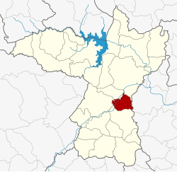
Ban Haet district
|
Ban Haet บ้าน แฮ ด |
|
|---|---|
| Province: | Khon Kaen |
| Surface: | 205.2 km² |
| Residents: | 32,717 (2013) |
| Population density : | 156.6 U / km² |
| ZIP : | 40110 |
| Geocode : | 4024 |
| map | |

|
|
Amphoe Ban Haet ( Thai : อำเภอ บ้าน แฮ ด ) is a district ( amphoe - administrative district) in the province of Khon Kaen . The province of Khon Kaen is located in the northeast region of Thailand , the so-called Isan .
geography
Neighboring counties (clockwise from the south): the Amphoe Ban Phai , Mancha Khiri , Phra Yuen and Mueang Khon Kaen in the province of Khon Kaen, and Amphoe Kosum Phisai in the province of Maha Sarakham .
history
Ban Haet was set up on April 1, 1995, initially as a "branch district" ( King Amphoe ) by separating the area of today's district from the Ban Phai district .
On May 15, 2007 the Thai government decided to raise all 81 King Amphoe to simple amphoe status in order to unify the administration. With the publication in the Royal Gazette "Issue 124 chapter 46" on August 24, 2007 this decision officially entered into force.
traffic
Ban Haet has a station on the northeast line of the Thai Railway ( Nakhon Ratchasima – Nong Khai line ). The Thanon Mittraphap ("Street of Friendship"; National Road 2) runs through the district .
Administrative units
Provincial Administration
The district of Ban Haet is divided into four tambon ("subdistricts" or "municipalities"), which are further subdivided into 45 muban ("villages").
| No. | Surname | Thai | Muban | Pop. |
|---|---|---|---|---|
| 1. | Ban Haet | บ้าน แฮ ด | 11 | 9,260 |
| 2. | Khok Samran | โคก สำราญ | 16 | 9,067 |
| 3. | Non sombun | โนน สมบูรณ์ | 11 | 9,311 |
| 4th | Nong Saeng | หนองแซง | 7th | 5,079 |
Local administration
There are three municipalities with "small town" status ( Thesaban Tambon ) in the district:
- Ban Haet (Thai: เทศบาล ตำบล บ้าน แฮ ด ), consisting of parts of the Tambon Ban Haet,
- Wang Sawan (Thai: เทศบาล ตำบล วัง สวรรค์ ), also consisting of (other) parts of the Tambon Ban Haet,
- Khok Samran (Thai: เทศบาล ตำบล โคก สำราญ ), consisting of the entire tambon Khok Samran.
There are also two " Tambon Administrative Organizations " ( องค์การ บริหาร ส่วน ตำบล - Tambon Administrative Organizations, TAO):
- Non Sombun (Thai: องค์การ บริหาร ส่วน ตำบล โนน สมบูรณ์ )
- Nong Saeng (Thai: องค์การ บริหาร ส่วน ตำบล หนองแซง )
Individual evidence
- ↑ ประกาศ กระทรวง มหาดไทย เรื่อง แบ่ง เขต ท้องที่ อำเภอ บ้านไผ่ จังหวัด ขอนแก่น ตั้ง เป็น กิ่ง อำเภอ บ้าน แฮ ด . In: Royal Gazette . 112, No. 9 ง special ( พิเศษ ), March 22, 1995, p. 64.
- ↑ แถลง ผล การ ประชุม ค รม. ประจำ วัน ที่ 15 พ.ค. 2550 (Thai) , Manager Online.
- ↑ พระราชกฤษฎีกา ตั้ง อำเภอ ฆ้องชัย ... และ อำเภอ เหล่า เสือ โก้ ก พ.ศ. ๒๕๕๐ . In: Royal Gazette . 124, No. 46 ก , August 24, 2007, pp. 14-21.
- ↑ 2013 population statistics ( Thai ) Department of Provincial Administration. Retrieved July 29, 2014.
Web links
Coordinates: 16 ° 12 ' N , 102 ° 45' E
