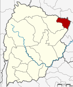
Amphoe Ban Thaen
|
Ban Thaen บ้านแท่น |
|
|---|---|
| Province: | Chaiyaphum |
| Surface: | 308.707 km² |
| Residents: | 45,743 (2013) |
| Population density : | 142.5 U / km² |
| ZIP : | 36190 |
| Geocode : | 3611 |
| map | |

|
|
Amphoe Ban Thaen ( Thai : อำเภอ บ้านแท่น ) is a district ( Amphoe - administrative district) in the northeast of Chaiyaphum Province . The province of Chaiyaphum is located in the northeast region of Thailand , the so-called Isan .
geography
The neighboring districts start clockwise from the southwest: the Amphoe Kaeng Khro and Phu Khiao in the province of Chaiyaphum and the Amphoe Nong Ruea and Mancha Khiri in the province of Khon Kaen .
history
Ban Thaen was initially set up on June 16, 1965 as a "branch circle" ( King Amphoe ) by separating the Tambon Sam Suan, Ban Tao and Ban Thaen from the Phu Khiao district . It was promoted to Amphoe on February 25, 1969.
administration
Provincial Administration
The district of Ban Thaen is divided into 5 tambon ("sub-districts" or "municipalities"), which are further subdivided into 66 muban ("villages").
| No. | Surname | Thai | Muban | Pop. |
|---|---|---|---|---|
| 1. | Ban Thaen | บ้านแท่น | 16 | 12,904 |
| 2. | Sam Suan | สาม สวน | 18th | 10,809 |
| 3. | Sa Phang | สระ พัง | 9 | 5,755 |
| 4th | Ban Tao | บ้าน เต่า | 13 | 9,445 |
| 5. | Nong Khu | หนอง คู | 10 | 6,830 |
Local administration
There are two municipalities with "small town" status ( Thesaban Tambon ) in the district:
- Ban Tao (Thai: เทศบาล ตำบล บ้าน เต่า ) consists of the whole tambon Ban Tao.
- Ban Thaen (Thai: เทศบาล ตำบล บ้านแท่น ) consists of parts of the Tambon Ban Thaen.
There are also four " Tambon Administrative Organizations " ( องค์การ บริหาร ส่วน ตำบล - Tambon Administrative Organizations, TAO):
- Ban Thaen (Thai: องค์การ บริหาร ส่วน ตำบล บ้านแท่น )
- Sam Suan (Thai: องค์การ บริหาร ส่วน ตำบล สาม สวน )
- Sa Phang (Thai: องค์การ บริหาร ส่วน ตำบล สระ พัง )
- Nong Khu (Thai: องค์การ บริหาร ส่วน ตำบล หนอง คู )
Individual evidence
- ↑ ประกาศ กระทรวง มหาดไทย เรื่อง แบ่ง ท้องที่ ตั้ง เป็น กิ่ง อำเภอ . In: Royal Gazette . 81, No. 47 ง , June 15, 1965, p. 1616-.
- ↑ พระราชกฤษฎีกา จัดตั้ง อำเภอ สมเด็จ อำเภอ สีชมพู อำเภอ หนองบัวแดง อำเภอ บ้านแท่น อำเภอ ดอนตูม อำเภอ นากลาง อำเภอ ศรีบุญเรือง และ อำเภอ ป่าติ้ว พ.ศ. ๒๕๑๒ . In: Royal Gazette . 86, No. 16 ก , February 25, 1969, pp. 225-229.
- ↑ 2013 population statistics ( Thai ) Department of Provincial Administration. Retrieved July 28, 2014.
Web links
Coordinates: 15 ° 34 ' N , 101 ° 51' E
