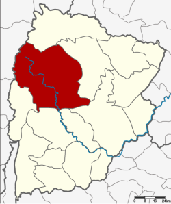
Amphoe Nong Bua Daeng
|
Nong Bua Daeng หนองบัวแดง |
|
|---|---|
| Province: | Chaiyaphum |
| Surface: | 2215.5 km² |
| Residents: | 100,347 (2013) |
| Population density : | 41.9 U / km² |
| ZIP : | 36210 |
| Geocode : | 3605 |
| map | |

|
|
Amphoe Nong Bua Daeng ( Thai : อำเภอ หนองบัวแดง ) is a district ( Amphoe - administrative district) in Chaiyaphum Province . The province of Chaiyaphum is located in the northeast region of Thailand , the so-called Isan .
geography
Neighboring districts (clockwise from north): the Amphoe Khon San , Kaset Sombun , Mueang Chaiyaphum , Ban Khwao , Nong Bua Rawe and Phakdi Chumphon in the province of Chaiyaphum and the Amphoe Nong Phai and Mueang Phetchabun in the province of Phetchabun .
The west of the district is occupied by part of the densely forested Phetchabun Mountains . This is where the Mae Nam Chi originates . The Phu Laen Kha National Park is located on the southern edge of Amphoe Nong Bua Daeng .
history
Nong Bua Daeng was initially set up on July 16, 1965 as a “branch circle” ( King Amphoe ) by separating the two tambon Nong Bua Daeng and Nang Daet from the Kaset Sombun district . On April 1, 1969, it was officially given full amphoe status.
administration
Provincial Administration
Nong Bua Daeng County is divided into 8 tambon ("subdistricts" or "communities"), which are further subdivided into 130 muban ("villages").
| No. | Surname | Thai | Muban | Pop. |
|---|---|---|---|---|
| 1. | Nong Bua Daeng | หนองบัวแดง | 19th | 17,708 |
| 2. | Kut Chum Saeng | กุดชุม แสง | 18th | 14,079 |
| 3. | Tham Wua Daeng | ถ้ำ วัว แดง | 12 | 10.160 |
| 4th | Nang Daet | นาง แดด | 22nd | 14,124 |
| 7th | Nong Waeng | หนอง แวง | 20th | 15,265 |
| 8th. | Khu Mueang | คูเมือง | 17th | 12,085 |
| 9. | Tha Yai | ท่า ใหญ่ | 11 | 8,971 |
| 11. | Wang Chomphu | วัง ชม ภู | 11 | 7,955 |
Note: the missing numbers (geocodes) refer to the tambon , which today belong to the Amphoe Phakdi Chumphon .
Local administration
There are two municipalities with "small town" status ( Thesaban Tambon ) in the district:
- Luang Siri (Thai: เทศบาล ตำบล หลวง ศิริ ) consists of parts of the Tambon Nong Bua Daeng.
- Nong Bua Daeng (Thai: เทศบาล ตำบล หนองบัวแดง ) consists of the remaining parts of the Tambon Nong Bua Daeng.
There are also seven " Tambon Administrative Organizations " ( องค์การ บริหาร ส่วน ตำบล - Tambon Administrative Organizations, TAO):
- Kut Chum Saeng (Thai: องค์การ บริหาร ส่วน ตำบล กุดชุม แสง )
- Tham Wua Daeng (Thai: องค์การ บริหาร ส่วน ตำบล ถ้ำ วัว แดง )
- Nang Daet (Thai: องค์การ บริหาร ส่วน ตำบล นาง แดด )
- Nong Waeng (Thai: องค์การ บริหาร ส่วน ตำบล หนอง แวง )
- Khu Mueang (Thai: องค์การ บริหาร ส่วน ตำบล คูเมือง )
- Tha Yai (Thai: องค์การ บริหาร ส่วน ตำบล ท่า ใหญ่ )
- Wang Chomphu (Thai: องค์การ บริหาร ส่วน ตำบล วัง ชม ภู )
Individual evidence
- ↑ ประกาศ กระทรวง มหาดไทย เรื่อง แบ่ง ท้องที่ ตั้ง เป็น กิ่ง อำเภอ . In: Royal Gazette . 82, No. 57 ง , July 20 1965, p. 1878.
- ↑ พระราชกฤษฎีกา จัดตั้ง อำเภอ สมเด็จ อำเภอ สีชมพู อำเภอ หนองบัวแดง อำเภอ บ้านแท่น อำเภอ ดอนตูม อำเภอ นากลาง อำเภอ ศรีบุญเรือง และ อำเภอ ป่าติ้ว พ.ศ. ๒๕๑๒ . In: Royal Gazette . 86, No. 16 ก , February 25 1969, pp. 225-229.
- ↑ 2013 population statistics ( Thai ) Department of Provincial Administration. Retrieved July 28, 2014.
Web links
Coordinates: 16 ° 5 ' N , 101 ° 48' E
