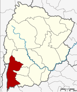
Amphoe Thep Sathit
|
Thep Sathit เทพสถิต |
|
|---|---|
| Province: | Chaiyaphum |
| Surface: | 875.6 km² |
| Residents: | 68,689 (2013) |
| Population density : | 75.1 E./km² |
| ZIP : | 36230 |
| Geocode : | 3609 |
| map | |

|
|
Amphoe Thep Sathit ( Thai : อำเภอ เทพสถิต ) is a district ( Amphoe - administrative district) in the province of Chaiyaphum . The province of Chaiyaphum is located in the northeast region of Thailand , the so-called Isan .
geography
Neighboring districts (clockwise from north): Amphoe Phakdi Chumphon , Nong Bua Rawe , Sap Yai , Bamnet Narong in Chaiyaphum Province, Amphoe Thepharak in Nakhon Ratchasima Province , Amphoe Lam Sonthi in Lop Buri Province and Amphoe Wichian Buri in the Phetchabun Province .
The Pa Hin Ngam National Park is located in Amphoe Thep Sathit .
history
Thep Sathit was first established on November 1, 1976 as a "branch circle" ( King Amphoe ) by separating the three tambon Wa Tabaek, Na Yang Klak and Huai Yai Chio from the Bamnet Narong district . On April 1, 1983, Thep Sathit got full amphoe status.
administration
Provincial Administration
The district of Thep Sathit is divided into five tambon ("subdistricts" or "parishes"), which are further subdivided into 92 Muban ("villages").
| No. | Surname | Thai | Muban | Pop. |
|---|---|---|---|---|
| 1. | Wa Tabaek | วะ ตะแบก | 22nd | 17,254 |
| 2. | Huai Yai Chio | ห้วย ยาย จิ๋ว | 22nd | 13,541 |
| 3. | Well Yang Klak | นา ยาง กลัก | 17th | 13,637 |
| 4th | Ban Rai | บ้านไร่ | 16 | 12,464 |
| 5. | Pong Nok | โป่ง นก | 15th | 11,793 |
Local administration
There is one municipality with "small town" status ( Thesaban Tambon ) in the district:
- Thep Sathit (Thai: เทศบาล ตำบล เทพสถิต ) consists of parts of the Tambon Wa Tabaek.
There are also five " Tambon Administrative Organizations " ( องค์การ บริหาร ส่วน ตำบล - Tambon Administrative Organizations, TAO):
- Wa Tabaek (Thai: องค์การ บริหาร ส่วน ตำบล วะ ตะแบก )
- Huai Yai Chio (Thai: องค์การ บริหาร ส่วน ตำบล ห้วย ยาย จิ๋ว )
- Na Yang Klak (Thai: องค์การ บริหาร ส่วน ตำบล นา ยาง กลัก )
- Ban Rai (Thai: องค์การ บริหาร ส่วน ตำบล บ้านไร่ )
- Pong Nok (Thai: องค์การ บริหาร ส่วน ตำบล โป่ง นก )
Individual evidence
- ↑ ประกาศ กระทรวง มหาดไทย เรื่อง แบ่ง ท้องที่ อำเภอ บำเหน็จณรงค์ จังหวัด ชัยภูมิ ตั้ง เป็น กิ่ง อำเภอ เทพสถิต . In: Royal Gazette . 93, No. 151 ง , November 9 1976, p. 3327.
- ↑ พระราชกฤษฎีกา ตั้ง อำเภอ เทพสถิต อำเภอ วังน้ำเย็น อำเภอ เนินมะปราง อำเภอ สวนผึ้ง และ อำเภอ เสนางคนิคม พ.ศ. ๒๕๒๖ . In: Royal Gazette . 100, No. 50 ก ฉบับ พิเศษ (special), March 31 1983, pp. 10-12.
- ↑ 2013 population statistics ( Thai ) Department of Provincial Administration. Retrieved July 28, 2014.
Web links
Coordinates: 15 ° 24 ' N , 101 ° 27' E
