Lop Buri (Province)
| Lop Buri | |
|---|---|
| ลพบุรี | |

|
|
| statistics | |
| Capital: | Lop Buri |
| Telephone code: | 036 |
| Surface: |
6,199.8 km² 37. |
| Residents: |
754.452 (2009) 33. |
| Population density : | 122 E / km² 39. |
| ISO 3166-2 : | |
| Governor : | |
| map | |
Lop Buri ( Thai : ลพบุรี or Lopburi) is a province ( Changwat ) in the central region of Thailand . The capital of the province is also called Lop Buri .
geography
The province lies in the east of the Mae Nam Chao Phraya plain ( Chao Phraya River ).
| Neighboring provinces: | |
|---|---|
| north | Phetchabun |
| east | Chaiyaphum and Nakhon Ratchasima |
| south | Saraburi and Ayutthaya |
| west | Ang Thong , Sing Buri and Nakhon Sawan |
Important rivers
climate
The climate is tropical - monsoonal . In 2009 there were 113 rainy days with an annual rainfall of 1206.3 mm.
Economy and Importance
The population lives from the productive agriculture on Mae Nam Chao Phraya.
In addition to rice (2009: 468,251 tons), the main products are also maize , fruit and cotton . About 64.1% of the province's area is agricultural land and 17.7% is forest.
In addition, tourism plays an important role in local working life. The "Gross Provincial Product" ( GDP ) of the province in 2008 was 74,966 million Baht . The average income in 2008 was 16,852 baht per month.
traffic
Airport
history
Prehistoric finds show that the area of the Khao Wong Prachan Valley dates back to around 2300 BC. Was inhabited by farmers. Some of the most important sites are at Non Pa Wai , Non Mak La (examined in 1994) and at Ban Tha Kae (1980).
The historical history of the province dates back at least to the 5th century when the provincial capital named Lavo was founded, and the city has been a major religious and political center since the 7th century . The area belonged to the sphere of influence of the Dvaravati empire of the Mon , whose art style was also developed into a so-called Lop-Buri style .
Since the 11th century , the area has been ruled by the Khmer , who left behind impressive buildings here. Lop Buri was the center of the Khmer in central Thailand, and their viceroy also resided here. Efforts for independence probably began early after the takeover by the Khmer, because two embassies were sent to the Chinese Empire (1001 and 1015). Lop Buri was tributary to the Khmer and had to deliver water from a holy lake to Angkor every three years , where the Khmer kings held sacred ceremonies to consolidate their god-kingship. At the end of the 13th century , the Thai kingdom Sukhothai took over sovereignty, but Lop Buri remained relatively independent.
The ancestors of the founder of Ayutthaya , Prince U Thong , are said to come from Lop Buri. From about 1360 the sovereignty passed to Ayutthaya .
King Narai (1656–1688) had his stone palace built here together with his Prime Minister Constantine Phaulkon from Greece , one of the first stone buildings in Thailand. Lop Buri thus became a second capital of the Ayutthaya Empire. According to the descriptions of European travelers, such as those of the ambassador of King Louis XIV , Lop Buri must have been a splendid city at the time.
Under his successors, however, the buildings were no longer used and fell into disrepair. Only King Mongkut (Rama IV.) Took parts of the facilities back from the jungle and had them restored.
Attractions
- Narai Ratchaniwet (Palace of King Narai) - decayed after the death of King Narai (1688), it was rebuilt under King Mongkut (Rama IV) in the mid- 19th century .
- Wat Phra Si Rattana Mahathat - a whole complex of Buddhist temples that come from two different epochs: in addition to prangs from the Khmer period, there are chedi from the Ayutthaya period
- National Museum - named after King Narai and one of Thailand's 32 national museums ; It is located in the palace of King Narai and contains a magnificent collection of Buddha statues as well as art treasures from the Dvaravati, Khmer and Ayutthaya periods.
- Ban Wichayen - the summer residence of the Greek adventurer Konstantin Falcon, who was promoted to chief minister under King Narai.
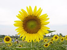
- Sunflowers - about 45 km east of the provincial capital Lop Buri in Amphoe Phatthana Nikhom is Thailand's largest sunflower plantation. In the heyday from November to January, many tourists come here to see the colorful spectacle.
Symbols
The seal of the province of Lop Buri shows the king Narai in front of the Khmer temple Phra Prang Sam Yot . The local tree and flower is the Mimusops elengi (Bullet Wood).
Lop Buri Province's motto is:
- "Here is the palace of Narai the great,
- Phra Kan, the city shrine is always praised,
- The land of Prang Sam Yot, ancient historical shrines,
- The province of the Din Saw Phong white powder mine,
- And the golden capital under King Narai. "
Administrative units
Provincial Administration
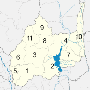
Lop Buri Province is divided into eleven Amphoe ('districts' or 'counties'), 124 tambon ('subdistricts' or 'municipalities') and 1110 muban ('village communities').
|
Local administration
A provincial administrative organization ( บริหาร ส่วน จังหวัด , อบ จ for short , Ongkan Borihan suan Changwat ; English Provincial Administrative Organization , PAO) exists for the entire area of the province .
There are three cities ( เทศบาล เมือง - Thesaban Mueang ) in Lop Buri Province: Lop Buri ( เทศบาล เมือง ลพบุรี ), Ban Mi ( เทศบาล เมือง บ้านหมี่ ) and Khao Sam Yot ( เทศบาล เมือง เขา สาม ยอด ). There are also 13 small towns ( เทศบาล ตำบล - Thesaban Tambon ).
Individual evidence
- ↑ Thailand in Figures (2011), p. 271
- ↑ Thailand in Figures (2011), p. 272
- ↑ Thailand in Figures (2011), p. 271
- ↑ Department of Provincial Administration , as of 2012 (in Thai)
literature
- Thailand in Figures . 13. A. Nonthaburi: Alpha Research 2011. ISBN 978-616-7526-03-4 .
Web links
- Overview map of the province (names in Thai and English) [last accessed on November 5, 2013]
Coordinates: 14 ° 48 ' N , 100 ° 39' E


