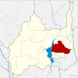
Amphoe Tha Luang
|
Tha Luang ท่า หลวง |
|
|---|---|
| Province: | Lop Buri |
| Surface: | 538.9 km² |
| Residents: | 29,235 (2013) |
| Population density : | 52.0 U / km² |
| ZIP : | 15230 |
| Geocode : | 1607 |
| map | |

|
|
Amphoe Tha Luang ( Thai : อำเภอ ท่า หลวง ) is a district ( Amphoe - administrative district) in the east of Lop Buri Province . Lop Buri Province is located in the central region of Thailand .
geography
Neighboring Amphoe can be seen from the north: the Amphoe Chai Badan and Lam Sonthi in the province of Lop Buri, Muak Lek in the province of Saraburi and Amphoe Phatthana Nikhom in Lop Buri.
The Pa-Sak-Chonlasit Dam (Thai: เขื่อน ป่า สัก ชล สิทธ ), which was created by damming the Maenam Pa Sak (Pa-Sak River) , is the main water resource of the district. It is used for both fishing and irrigation.
history
Amphoe Tha Luang was initially set up as a “branch circle” ( King Amphoe ) on November 15, 1978 by separating the four tambon Tha Luang, Sab Champa , Nong Phak Waen and Kaeng Phak Kut from the Chai Badan district . It was promoted to Amphoe on May 26, 1989.
administration
Provincial Administration
The district of Tha Luang is divided into six tambon ("subdistricts" or "communities"), which are further divided into 45 muban ("villages").
| No. | Surname | Thai | Muban | Pop. |
|---|---|---|---|---|
| 1. | Tha Luang | ท่า หลวง | 9 | 8,845 |
| 2. | Kaeng Phak Kut | แก่ง ผัก กูด | 8th | 4,104 |
| 3. | Sap Champa | ซับ จำปา | 7th | 4,432 |
| 4th | Nong Phak Waen | หนอง ผักแว่น | 8th | 4,685 |
| 5. | Thale Wang Wat | ทะเล วัง วัด | 5 | 1,512 |
| 6th | Hua Lam | หัว ลำ | 8th | 5,657 |
Local administration
There is one municipality with "small town" status ( Thesaban Tambon ) in the district:
- Ban Tha Luang (Thai: เทศบาล ตำบล บ้าน ท่า หลวง ) consisting of parts of the Tambon Tha Luang.
There are also five " tambon administration organizations " ( องค์การ บริหาร ส่วน ตำบล - Tambon Administrative Organizations, TAO)
- Tha Luang (Thai: องค์การ บริหาร ส่วน ตำบล ท่า หลวง ) consisting of parts of the Tambon Tha Luang.
- Kaeng Phak Kut (Thai: องค์การ บริหาร ส่วน ตำบล แก่ง ผัก กูด ) consisting of the complete tambon Kaeng Phak Kut, Thale Wang Wat.
- Sap Champa (Thai: องค์การ บริหาร ส่วน ตำบล ซับ จำปา ) consisting of the complete Tambon Sap Champa.
- Nong Phak Waen (Thai: องค์การ บริหาร ส่วน ตำบล หนอง ผักแว่น ) consisting of the complete Tambon Nong Phak Waen.
- Hua Lam (Thai: องค์การ บริหาร ส่วน ตำบล หัว ลำ ) consisting of the complete Tambon Hua Lam.
Individual evidence
- ↑ ประกาศ กระทรวง มหาดไทย เรื่อง แบ่ง ท้องที่ อำเภอ ชัยบาดาล จังหวัด ลพบุรี ตั้ง เป็น กิ่ง อำเภอ ท่า หลวง Royal Gazette, Volume 95, Ed. 132 ง of November 28, 1978, p. 4235 (in Thai)
- ↑ พระราชกฤษฎีกา ตั้ง อำเภอ แวงใหญ่ อำเภอ หนอง บุ น นา ก อำเภอ โพนทราย อำเภอ ท่า หลวง และ อำเภอ ศรี รัตนะ พ.ศ. ๒๕๓๒ Royal Gazette, Volume 106, Ed. 83 ก ฉบับ พิเศษ (special) from May 25, 1989, pp. 249-251 (in Thai)
- ↑ 2013 population statistics ( Thai ) Department of Provincial Administration. Retrieved September 3, 2014.
Web links
Coordinates: 15 ° 4 ′ N , 101 ° 6 ′ E
