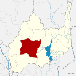
Amphoe Khok Samrong
|
Khok Samrong โคกสำโรง |
|
|---|---|
| Province: | Lop Buri |
| Surface: | 982.5 km² |
| Residents: | 85,721 (2013) |
| Population density : | 87.9 U / km² |
| ZIP : | 15120 |
| Geocode : | 1603 |
| map | |

|
|
Amphoe Khok Samrong ( Thai : อำเภอ โคกสำโรง ) is a district ( Amphoe - administrative district) in the center of Lop Buri Province . Lop Buri Province is located in the northeast of the central region of Thailand .
The district is the transportation center of the province.
geography
Neighboring districts are seen from the north: the Amphoe Nong Muang , Sa Bot , Chai Badan , Phatthana Nikhom , Mueang Lop Buri and Ban Mi . All Amphoe are also in Lop Buri Province.
history
The original name of the district was Phu Kha. As a "branch circle" ( King Amphoe ) , it was renamed Sa Bot in 1909. In 1915, the district was upgraded to Amphoe and renamed Khok Samrong at the same time the district's administrative building was moved to this tambon .
education
The Lop Buri Campus of Kasetsart University is located in Tambon Phaniat.
administration
Provincial Administration
The district of Khok Samrong is divided into 13 tambon ("subdistricts" or "communities"), which are further subdivided into 137 muban ("villages").
| No. | Surname | Thai | Muban | Pop. |
|---|---|---|---|---|
| 1. | Khok Samrong | โคกสำโรง | 9 | 20,241 |
| 2. | Ko Kaeo | เกาะ แก้ว | 11 | 3,608 |
| 3. | Thalung Lek | ถลุง เหล็ก | 8th | 3,671 |
| 4th | Lum Khao | หลุม ข้าว | 11 | 3,374 |
| 5. | Huai Pong | ห้วย โป่ง | 12 | 9,801 |
| 6th | Khlong Ket | คลอง เกตุ | 10 | 6,531 |
| 7th | Sakae rap | สะแก ราบ | 15th | 6,811 |
| 8th. | Phaniat | เพนียด | 10 | 7.111 |
| 9. | Wang Phloeng | วัง เพลิง | 13 | 7,533 |
| 10. | Dong Marum | ดง มะรุม | 12 | 5,634 |
| 18th | Wang Khon Khwang | วัง ขอน ขว้าง | 6th | 3,768 |
| 20th | Wang Chan | วัง จั่น | 7th | 2,987 |
| 22nd | Nong Khaem | หนองแขม | 13 | 4,651 |
Notes: The missing geocodes belong to the tambon that make up Amphoe Nong Muang and Amphoe Khok Charoen today.
Local administration
There is one municipality with "small town" status ( Thesaban Tambon ) in the district:
- Khok Samrong (Thai: เทศบาล ตำบล โคกสำโรง ) consisting of parts of the tambon Khok Samrong.
There are also 13 " tambon administration organizations " ( องค์การ บริหาร ส่วน ตำบล - Tambon Administrative Organizations, TAO)
- Khok Samrong (Thai: องค์การ บริหาร ส่วน ตำบล โคกสำโรง ) consisting of parts of the Tambon Khok Samrong.
- Ko Kaeo (Thai: องค์การ บริหาร ส่วน ตำบล เกาะ แก้ว ) consisting of the complete Tambon Ko Kaeo.
- Thalung Lek (Thai: องค์การ บริหาร ส่วน ตำบล ถลุง เหล็ก ) consisting of the complete Tambon Thalung Lek.
- Lum Khao (Thai: องค์การ บริหาร ส่วน ตำบล หลุม ข้าว ) consisting of the complete tambon Lum Khao.
- Huai Pong (Thai: องค์การ บริหาร ส่วน ตำบล ห้วย โป่ง ) consisting of the complete tambon Huai Pong.
- Khlong Ket (Thai: องค์การ บริหาร ส่วน ตำบล คลอง เกตุ ) consisting of the complete Tambon Khlong Ket.
- Sakae Rap (Thai: องค์การ บริหาร ส่วน ตำบล สะแก ราบ ) consisting of the complete Tambon Sakae Rap.
- Phaniat (Thai: องค์การ บริหาร ส่วน ตำบล เพนียด ) consisting of the complete Tambon Phaniat.
- Wang Phloeng (Thai: องค์การ บริหารส่วน ตำบล วัง เพลิง ) consisting of the complete tambon Wang Phloeng.
- Dong Marum (Thai: องค์การ บริหาร ส่วน ตำบล ดง มะรุม ) consisting of the complete Tambon Dong Marum.
- Wang Khon Khwang (Thai: องค์การ บริหาร ส่วน ตำบล วัง ขอน ขว้าง ) consisting of the complete tambon Wang Khon Khwang.
- Wang Chan (Thai: องค์การ บริหาร ส่วน ตำบล วัง จั่น ) consisting of the complete tambon Wang Chan.
- Nong Khaem (Thai: องค์การ บริหาร ส่วน ตำบล หนองแขม ) consisting of the complete Tambon Nong Khaem.
Individual evidence
- ↑ 2013 population statistics ( Thai ) Department of Provincial Administration. Retrieved August 29, 2014.
Web links
Coordinates: 15 ° 4 ′ N , 100 ° 43 ′ E
