
Sing Buri (Province)
| Sing Buri | |
|---|---|
| สิงห์บุรี | |

|
|
| statistics | |
| Capital: | Sing Buri |
| Telephone code: | 035 |
| Surface: |
822.5 km² 73. |
| Residents: |
215.299 (2009) 73. |
| Population density : | 279 E / km² 11. |
| ISO 3166-2 : | |
| Governor : | |
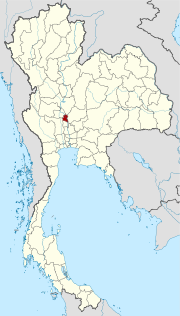
| map | |
  |
|
Sing Buri ( Thai : สิงห์บุรี , [ sǐŋ būrīː ]) is a province ( Changwat ) in the central region of Thailand .
geography
Sing Buri is located in the lowlands along the Mae Nam Chao Phraya ( Chao Phraya River ) about 140 kilometers north of Bangkok .
| Bordering provinces: | |
|---|---|
| north | Nakhon Sawan |
| east | Lop Buri |
| south | Ang Thong |
| west | Suphan Buri and Chai Nat |
history
Sing Buri was probably already settled during the Dvaravati period. The province played an important role during the Ayutthaya period , most recently in the Burmese campaign in 1765 against the Siamese empire ruled by King Ekathat . When the Burmese army rested north of Ayutthaya, eleven residents of the village of Bang Rachan attacked the army. They managed to delay the attack on the capital for five months before they were ultimately defeated. Even so, they couldn't stop the fall of Ayutthaya. A memorial service for the heroes is held annually on February 4th.
The former provinces In Buri , Phrom Buri and Sing Buri were combined in 1895 by King Chulalongkorn (Rama V) to form what is now Sing Buri Province.
economy
The "Gross Provincial Product" ( GDP ) of the province in 2009 amounted to 24,744 million in Baht . More than 88% of the province's area is designated as agriculturally useful.
Attractions
- The Khai Bang Rachan Park is a monument to the heroes of Bang Rachan (see story). A statue of the heroes was inaugurated by King Bhumibol Adulyadej (Rama IX) . A replica of the fort is built here. In Wat Pho Kao Ton (Monastery of the Nine Bodhi Trees) is in a viharn to see the statue of Phra Achan Thammachot, which is regarded as the leader of the heroes of Bang Rachan a Buddhist monk. The park is located about 13 km east of the provincial capital Sing Buri.
- Wat Sawang Arom Monastery in Sing Buri is the center for the manufacture of Buddha statues . With almost 300 pieces, it has one of the largest collections of Nang Yai figures in Thailand. Nang Yai ("Big Leather") is a shadow play that is played with two-dimensional figures carved out of buffalo leather.
- Wat Phra Non Chaksi is about 4 kilometers south of Sing Buri. A 46-meter reclining Sukhothai-style Buddha statue is highly revered by the locals.
Symbols
The seal shows the fort of Khai Bang Rachan, a copy of the historical building (see section History), which can be viewed in a park today.
The local tree is the red sandalwood tree ( Adenanthera pavonina ).
Sing Buri Province's motto is:
- "Land of the brave
Chaksi, reclining Buddha ,
salted Mae La fish are the best,
a trading center in the central region."
Administrative units
Provincial Administration
The province is divided into six amphoe (“districts” or “counties”), 43 tambon (“subdistricts” or “municipalities”) and 364 muban (“villages”).
|

Local administration
A provincial administrative organization ( บริหาร ส่วน จังหวัด , อบ จ for short , Ongkan Borihan suan Changwat ; English Provincial Administrative Organization , PAO) exists for the entire area of the province .
In the area of the province there is a "city" ( เทศบาล Mu - Thesaban Mueang ), Sing Buri ( เทศบาล เมือง สิงห์บุรี ). There are also six “small towns” ( เทศบาล ตำบล - Thesaban Tambon ).
Individual evidence
- ↑ Source: Thailand in Figures . 13th edition 2011
- ↑ Department of Provincial Administration , as of 2012 (in Thai)
Web links
- Outline map of Sing Buri Province (names in English and Thai) [last accessed November 4, 2013]
North : Chiang Mai | Chiang Rai | Kamphaeng Phet | Lampang | Lamphun | Mae Hong Son | Nakhon Sawan | Nan | Phayao | Phetchabun | Phichit | Phitsanulok | Phrae | Sukhothai | Tak | Uthai Thani | Uttaradit
Northeast : Amnat Charoen | Bueng Kan | Buri Ram | Chaiyaphum | Kalasin | Khon Kaen | Loei | Maha Sarakham | Mukdahan | Nakhon Phanom | Nakhon Ratchasima | Nong Bua Lam Phu | Nong Khai | Roi Et | Sakon Nakhon | Si Sa Ket | Surin | Ubon Ratchathani | Udon Thani | Yasothon
Central : Ang Thong | Ayutthaya | Bangkok | Chachoengsao | Chai Nat | Chanthaburi | Chon Buri | Kanchanaburi | Lop Buri | Nakhon Nayok | Nakhon Pathom | Nonthaburi | Pathum Thani | Phetchaburi | Prachin Buri | Prachuap Khiri Khan | Ratchaburi | Rayong | Sa Kaeo | Samut Prakan | Samut Sakhon | Samut Songkhram | Saraburi | Sing Buri | Suphan Buri | Stepped
South : Chumphon | Krabi | Nakhon Si Thammarat | Narathiwat | Pattani | Phang-nga | Phatthalung | Phuket | Ranong | Satun | Songkhla | Surat Thani | Trang | Yala
Coordinates: 14 ° 54 ' N , 100 ° 25' E