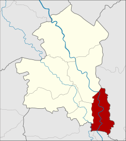
Amphoe Phrom Buri
|
Phrom Buri พรหมบุรี |
|
|---|---|
| Province: | Sing Buri |
| Surface: | 82.5 km² |
| Residents: | 24,119 (2013) |
| Population density : | 294.6 U / km² |
| ZIP : | 16120, 16160 |
| Geocode : | 1704 |
| map | |

|
|
Amphoe Phrom Buri ( Thai : อำเภอ พรหมบุรี ) is a district ( Amphoe - administrative district) in the eastern part of Sing Buri Province . Sing Buri Province is located in the central region of Thailand .
geography
Neighboring districts (clockwise from east): Amphoe Tha Wung of Lop Buri Province , Amphoe Chaiyo and Pho Thong of Ang Thong Province, and Amphoe Tha Chang and Mueang Sing Buri of Sing Buri Province.
history
The city ( Mueang ) Phrom Buri already existed before the establishment of the Ayutthaya Kingdom by King U Thong . The historic city was near Wat Amphawan in Tambon Phrom Buri. The city was later relocated north of Wat Phromma Thephawat to Pak Bang Mhuen Han ( ปาก บาง หมื่น หาญ ).
The thesaphiban reforms towards the end of the 19th century made Phrom Buri a province within the “Monthon Krungkao”, which was renamed “Monthon Ayutthaya” in 1895. In the 20th century, Phrom Buri was downgraded to a county in Sing Buri Province.
administration
Provincial Administration
Phrom Buri County is divided into seven tambon ("subdistricts" or "municipalities"), which are further subdivided into 42 muban ("villages").
| No. | Surname | Thai | Muban | Pop. |
|---|---|---|---|---|
| 1. | Phra Ngam | พระ งาม | 6th | 3,836 |
| 2. | Phrom Buri | พรหมบุรี | 6th | 3,317 |
| 3. | Bang Nam Chiao | บาง น้ำ เชี่ยว | 6th | 3,656 |
| 4th | Ban Mo | บ้านหม้อ | 8th | 6.171 |
| 5. | Ban Paeng | บ้าน แป้ง | 6th | 2,289 |
| 6th | Hua Pa | หัวป่า | 4th | 1,479 |
| 7th | Rong Chang | โรง ช้าง | 6th | 3,371 |
Local administration
There are two municipalities with "small town" status ( Thesaban Tambon ) in the district:
- Bang Nam Chiao (Thai: เทศบาล ตำบล บาง น้ำ เชี่ยว ) consisting of the complete tambon Bang Nam Chiao.
- Pak Bang (Thai: เทศบาล ตำบล ปาก บาง ) consisting of the complete Tambon Phrom Buri.
There are also four " tambon administration organizations " ( องค์การ บริหาร ส่วน ตำบล - Tambon Administrative Organizations, TAO)
- Phra Ngam (Thai: องค์การ บริหาร ส่วน ตำบล พระ งาม ) consisting of the complete tambon Phra Ngam.
- Ban Mo (Thai: องค์การ บริหาร ส่วน ตำบล บ้านหม้อ ) consisting of the complete tambon Ban Mo.
- Ban Paeng (Thai: องค์การ บริหาร ส่วน ตำบล บ้าน แป้ง ) consisting of the complete tambon Ban Paeng.
- Rong Chang (Thai: องค์การ บริหาร ส่วน ตำบล โรง ช้าง ) consisting of the complete Tambon Rong Chang, Hua Pa.
Individual evidence
- ↑ 2013 population statistics ( Thai ) Department of Provincial Administration. Retrieved September 9, 2014.
Web links
Coordinates: 14 ° 47 ' N , 100 ° 27' E