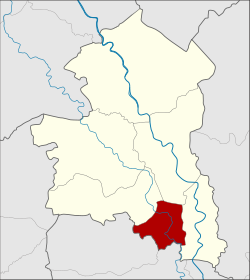
Amphoe Tha Chang (Sing Buri)
|
Tha Chang ท่าช้าง |
|
|---|---|
| Province: | Sing Buri |
| Surface: | 34.4 km² |
| Residents: | 14,768 (2013) |
| Population density : | 472.6 U / km² |
| ZIP : | 16140 |
| Geocode : | 1705 |
| map | |

|
|
Amphoe Tha Chang ( Thai : อำเภอ ท่าช้าง , literally: elephant pier ) is a district ( Amphoe - administrative district) in the southern part of Sing Buri Province . Sing Buri Province is located in the central region of Thailand .
geography
The Maenam Noi (Noi River) is the county's main water resource. It is a fertile river with wide, sandy banks. It was used in the past to bathe the royal elephants.
Neighboring districts (clockwise from west): Amphoe Khai Bang Rachan , Amphoe Mueang Sing Buri and Amphoe Phrom Buri of Sing Buri Province, and Amphoe Chaiyo and Pho Thong of Ang Thong Province .
history
The district of Tha Chang was initially established as a "branch district" ( King Amphoe ) in 1960 by separating three tambon of the Phrom Buri district . In 1963, Tha Chang got full amphoe status.
administration
Provincial Administration
Tha Chang County is divided into four tambon ("subdistricts" or "parishes"), which are further divided into 23 muban ("villages").
| No. | Surname | Thai | Muban | Pop. |
|---|---|---|---|---|
| 1. | Thon Samo | ถอนสมอ | 8th | 6,170 |
| 2. | Pho Prachak | โพ ประจักษ์ | 5 | 3,554 |
| 3. | Wihan Khao | วิหาร ขาว | 5 | 1.956 |
| 4th | Phikun Thong | พิกุล ทอง | 5 | 3,088 |
Local administration
There is one municipality with "small town" status ( Thesaban Tambon ) in the district:
- Thon Samo (Thai: เทศบาล ตำบล ถอนสมอ ) consisting of the complete Tambon Thon Samo, Phikun Thong.
There are also two " tambon administration organizations " ( องค์การ บริหาร ส่วน ตำบล - Tambon Administrative Organizations, TAO)
- Pho Prachak (Thai: องค์การ บริหารส่วน ตำบล โพ ประจักษ์ ) consisting of the complete tambon Pho Prachak.
- Wihan Khao (Thai: องค์การ บริหาร ส่วน ตำบล วิหาร ขาว ) consisting of the complete tambon Wihan Khao.
Individual evidence
- ↑ ประกาศ กระทรวง มหาดไทย เรื่อง ยก ฐานะ ตำบล ขึ้น เป็น กิ่ง อำเภอ Royal Gazette Volume 77, Ed. 108 ง of December 27, 1960, p. 2562 (in Thai)
- ↑ พระราชกฤษฎีกา ตั้ง อำเภอ บ่อพลอย อำเภอ ไทรโยค อำเภอ หนองเรือ อำเภอ หนองสองห้อง อำเภอ ประทาย อำเภอ ห้วยแถลง อำเภอ ละหานทราย อำเภอ กุยบุรี อำเภอ ตาพระยา อำเภอ หนองไผ่ อำเภอ นาเชือก อำเภอ อำเภอ วัดเพลง อำเภอ พนัสนิคม อำเภอ ภูกระดึง ภูกระดึง อำเภอ ปรางค์กู่ อำเภอ ท่าช้าง อำเภอ บ้านด่านลานหอย อำเภอ บ้าน ดง อำเภอ สว่างอารมณ์ และ อำเภอ กุดชุม พ.ศ. ๒๕๐๖ Royal Gazette Volume 80, Ed. 72 ก July 16, 1963, p. 362 (in Thai)
- ↑ 2013 population statistics ( Thai ) Department of Provincial Administration. Retrieved September 9, 2014.
Web links
Coordinates: 14 ° 46 ' N , 100 ° 23' E