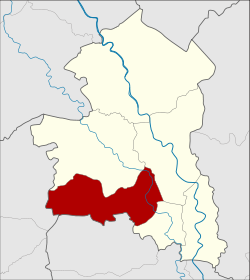
Khai Bang Rachan district
|
Khai Bang Rachan ค่ายบางระจัน |
|
|---|---|
| Province: | Sing Buri |
| Surface: | 88.398 km² |
| Residents: | 28,315 (2013) |
| Population density : | 319.7 U / km² |
| ZIP : | 16150 |
| Geocode : | 1703 |
| map | |

|
|
Amphoe Khai Bang Rachan ( Thai : อำเภอ ค่ายบางระจัน ) is a county ( Amphoe - Administrative District ) of Sing Buri Province . Sing Buri Province is located in the central region of Thailand .
geography
Neighboring districts (clockwise from north): Amphoe Bang Rachan , Amphoe Mueang Sing Buri and Amphoe Tha Chang of Sing Buri Province, Amphoe Sawaeng Ha of Ang Thong Province, and Amphoe Doem Bang Nang Buat of Suphan Buri Province .
history
According to Thai chronicles, during the Burmese campaign that ultimately led to the fall of the Kingdom of Ayutthaya in 1767 , the villagers of Bang Rachan put up bitter resistance to the invading forces, while the official Siamese forces of King Ekathat were no significant obstacle. The story is the subject of a period film from 2000.
In 1966, Khai Bang Rachan (Camp Bang Rachan) was renovated. In order to commemorate the historical theater of war near Bang Rachan, which is known in Thailand, it was decided to establish a new district. The area was separated from Bang Rachan Amphoe on February 1, 1972 and initially set up as a "branch circle" ( King Amphoe ) with five tambon . In 1976, Khai Bang Rachan officially got full amphoe status. The sixth Tambon Nong Krathum was established in 1980.
administration
Provincial Administration
Khai Bang Rachan County is divided into six tambon ("subdistricts" or "parishes"), which are further subdivided into 59 muban ("villages").
| No. | Surname | Thai | Muban | Pop. |
|---|---|---|---|---|
| 1. | Pho Thale | โพทะเล | 8th | 4,680 |
| 2. | Bang Rachan | บางระจัน | 11 | 7,375 |
| 3. | Pho Sangkho | โพ สั ง โฆ | 14th | 6,713 |
| 4th | Tha Kham | ท่า ข้าม | 14th | 4,477 |
| 5. | Kho Sai | คอ ทราย | 6th | 2,543 |
| 6th | Nong Krathum | หนอง กระทุ่ม | 6th | 2,527 |
Local administration
There is one municipality with "small town" status ( Thesaban Tambon ) in the district:
- Pho Sangkho (Thai: เทศบาล ตำบล โพ สั ง โฆ ) consisting of parts of the Tambon Pho Sangkho.
In addition, there are six " tambon administration organizations " ( องค์การ บริหาร ส่วน ตำบล - Tambon Administrative Organizations, TAO)
- Pho Thale (Thai: องค์การ บริหาร ส่วน ตำบล โพทะเล ) consisting of the complete Tambon Pho Thale.
- Khai Bang Rachan (Thai: องค์การ บริหาร ส่วน ตำบล ค่ายบางระจัน ) consisting of the complete Tambon Bang Rachan.
- Pho Sangkho (Thai: องค์การ บริหาร ส่วน ตำบล โพ สั ง โฆ ) consisting of parts of the Tambon Pho Sangkho.
- Tha Kham (Thai: องค์การ บริหาร ส่วน ตำบล ท่า ข้าม ) consisting of the complete Tambon Tha Kham.
- Kho Sai (Thai: องค์การ บริหาร ส่วน ตำบล คอ ทราย ) consisting of the complete tambon Kho Sai.
- Nong Krathum (Thai: องค์การ บริหาร ส่วน ตำบล หนอง กระทุ่ม ) consisting of the complete Tambon Nong Krathum.
Individual evidence
- ^ David K. Wyatt : Thailand. A short history. 2nd edition, Silkworm Books, Chiang Mai 2004, p. 118.
- ↑ ประกาศ กระทรวง มหาดไทย เรื่อง แบ่ง ท้องที่ อำเภอ บางระจัน ตั้ง เป็น กิ่ง อำเภอ ค่ายบางระจัน จังหวัด สิงห์บุรี Royal Gazette Volume 89, Ed. 17 ง of February 1, 1972, p. 178 (in Thai)
- ↑ พระราชกฤษฎีกา ตั้ง อำเภอ เลาขวัญ อำเภอ คำม่วง อำเภอ พิปูน อำเภอ ศรีเทพ อำเภอ นาแห้ว อำเภอ ส่องดาว อำเภอ ควนกาหลง อำเภอ ค่ายบางระจัน อำเภอ บ้านตาขุน และ อำเภอ กุดจับ พ.ศ. ๒๕๑๙ Royal Gazette Volume 93, Ed. 109 ก ฉบับ พิเศษ of September 8, 1976, pp. 31–34 (in Thai)
- ↑ ประกาศ กระทรวง มหาดไทย เรื่อง ตั้ง และ เปลี่ยนแปลง เขต ตำบล ใน ท้องที่ อำเภอ ค่ายบางระจัน จังหวัด สิงห์บุรี Royal Gazette Volume 97, Ed. 127 ง of August 19, 1980, p. 2811 (in Thai)
- ↑ 2013 population statistics ( Thai ) Department of Provincial Administration. Retrieved September 9, 2014.
Web links
Coordinates: 14 ° 48 ' N , 100 ° 19' E
