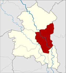
Amphoe Mueang Sing Buri
|
Amphoe Mueang Sing Buri อำเภอ เมือง สิงห์บุรี |
|
|---|---|
| Province: | Sing Buri |
| Surface: | 112.4 km² |
| Residents: | 54,521 (2013) |
| Population density : | 516.4 U / km² |
| ZIP : | 16000 |
| Geocode : | 1701 |
| map | |

|
|
Amphoe Mueang Sing Buri ( Thai : อำเภอ เมือง สิงห์บุรี ) is a district ( Amphoe - Administrative District) of Sing Buri Province . Sing Buri Province is located in the central region of Thailand .
geography
Sing Buri Province is located in the central region of Thailand .
Neighboring counties (clockwise from north): Amphoe In Buri of Sing Buri Province, Amphoe Tha Wung of Lop Buri Province , and Amphoe Phrom Buri , Tha Chang , Khai Bang Rachan and Bang Rachan again from Sing Buri Province.
administration
Provincial Administration
Mueang Sing Buri County is divided into eight tambon ("subdistricts" or "parishes"), which are further subdivided into 58 muban ("villages").
| No. | Surname | Thai | Muban | Pop. |
|---|---|---|---|---|
| 1. | Bang Phutsa | บาง พุทรา | - | 7,990 |
| 2. | Bang man | บาง มั ญ | 7th | 10,989 |
| 3. | Phok Ruam | โพ ก รวม | 7th | 3,638 |
| 4th | Muang Mu | ม่วง หมู่ | 5 | 6,527 |
| 5. | Hua Phai | หัว ไผ่ | 13 | 4,998 |
| 6th | Sound pho | ต้น โพธิ์ | 11 | 9,483 |
| 7th | Chaksi | จักร สีห์ | 7th | 3,671 |
| 8th. | Bang Krabue | บาง กระบือ | 8th | 7,225 |
Local administration
There is one commune with "city" status ( Thesaban Mueang ) in the district:
- Sing Buri (Thai: เทศบาล เมือง สิงห์บุรี ) consisting of the complete Tambon Bang Phutsa and the parts of the Tambon Bang Man, Muang Mu, Ton Pho, Bang Krabue.
In addition, there are seven " Tambon Administration Organizations " ( องค์การ บริหาร ส่วน ตำบล - Tambon Administrative Organizations, TAO)
- Bang Man (Thai: องค์การ บริหาร ส่วน ตำบล บาง มั ญ ) consisting of parts of the Tambon Bang Man.
- Phok Ruam (Thai: องค์การ บริหาร ส่วน ตำบล โพ ก รวม ) consisting of the complete tambon Phok Ruam.
- Muang Mu (Thai: องค์การ บริหาร ส่วน ตำบล ม่วง หมู่ ) consisting of parts of the Tambon Muang Mu.
- Hua Phai (Thai: องค์การ บริหาร ส่วน ตำบล หัว ไผ่ ) consisting of the complete Tambon Hua Phai.
- Ton Pho (Thai: องค์การ บริหาร ส่วน ตำบล ต้น โพธิ์ ) consisting of parts of the tambon Ton Pho.
- Chaksi (Thai: องค์การ บริหาร ส่วน ตำบล จักร สีห์ ) consisting of the complete Tambon Chaksi.
- Bang Krabue (Thai: องค์การ บริหาร ส่วน ตำบล บาง กระบือ ) consisting of parts of the Tambon Bang Krabue.
Individual evidence
- ↑ 2013 population statistics ( Thai ) Department of Provincial Administration. Retrieved September 8, 2014.
Web links
Coordinates: 14 ° 53 ' N , 100 ° 24' E