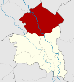
Amphoe in Buri
|
In Buri อินทร์บุรี |
|
|---|---|
| Province: | Sing Buri |
| Surface: | 314.3 km² |
| Residents: | 56,376 (2013) |
| Population density : | 183.8 U / km² |
| ZIP : | 16110 |
| Geocode : | 1706 |
| map | |

|
|
Amphoe In Buri ( Thai : อำเภอ อินทร์บุรี ) the northernmost district ( Amphoe - administrative district) is the Sing Buri . Sing Buri Province is located in the central region of Thailand .
geography
Neighboring districts (clockwise from the north): Amphoe Takhli of Nakhon Sawan Province , Amphoe Ban Mi of Lop Buri Province , Amphoe Mueang Sing Buri and Amphoe Bang Rachan of Sing Buri Province, and Amphoe Sapphaya and Sankhaburi of Chai Nat Province .
history
In the past, Buri was one of the largest city-states ( Mueang ) of Siam . It was founded in 1369 during the reign of King Ramesuan . In the Kingdom of Ayutthaya , the governor of In Buri has always been a member of the royal family as In Buri was the northern border town of the kingdom.
In 1895, during the Thesaphiban Administrative Reform, King Chulalongkorn (Rama V) demoted In Buri to part of Sing Buri. It later became a county in Sing Buri Province.
administration
Provincial Administration
The district in Buri is divided into ten tambon ("subdistricts" or "municipalities"), which are further divided into 105 muban ("villages").
| No. | Surname | Thai | Muban | Pop. |
|---|---|---|---|---|
| 1. | In Buri | อินทร์บุรี | 10 | 10,323 |
| 2. | Prasuk | ประศุ ก | 11 | 6,186 |
| 3. | Thap Ya | ทับ ยา | 12 | 6,055 |
| 4th | Ngio Rai | งิ้ว ราย | 10 | 5,549 |
| 5. | Chi Nam Rai | ชี น้ำ ร้าย | 8th | 4.124 |
| 6th | Tha Ngam | ท่า งาม | 11 | 5,283 |
| 7th | Nam Tan | น้ำตาล | 10 | 3,540 |
| 8th. | Thong En | ทอง เอน | 15th | 7,844 |
| 9. | Huai Chan | ห้วย ชัน | 10 | 5.013 |
| 10. | Pho Chai | โพธิ์ชัย | 8th | 2,459 |
Local administration
There are two municipalities with "small town" status ( Thesaban Tambon ) in the district:
- Thap Ya (Thai: เทศบาล ตำบล ทับ ยา ) consisting of the complete tambon Thap Ya.
- In Buri (Thai: เทศบาล ตำบล อินทร์บุรี ) consisting of parts of the Tambon In Buri.
In addition, there are nine " tambon administration organizations " ( องค์การ บริหาร ส่วน ตำบล - Tambon Administrative Organizations, TAO)
- In Buri (Thai: องค์การ บริหาร ส่วน ตำบล อินทร์บุรี ) consisting of parts of the Tambon In Buri.
- Prasuk (Thai: องค์การ บริหาร ส่วน ตำบล ประศุ ก ) consisting of the complete Tambon Prasuk.
- Ngio Rai (Thai: องค์การ บริหาร ส่วน ตำบล งิ้ว ราย ) consisting of the complete tambon Ngio Rai.
- Chi Nam Rai (Thai: องค์การ บริหาร ส่วน ตำบล ชี น้ำ ร้าย ) consisting of the complete tambon Chi Nam Rai.
- Tha Ngam (Thai: องค์การ บริหาร ส่วน ตำบล ท่า งาม ) consisting of the complete tambon Tha Ngam.
- Nam Tan (Thai: องค์การ บริหาร ส่วน ตำบล น้ำตาล ) consisting of the complete tambon Nam Tan.
- Thong En (Thai: องค์การ บริหาร ส่วน ตำบล ทอง เอน ) consisting of the complete Tambon Thong En.
- Huai Chan (Thai: องค์การ บริหาร ส่วน ตำบล ห้วย ชัน ) consisting of the complete tambon Huai Chan.
- Pho Chai (Thai: องค์การ บริหาร ส่วน ตำบล โพธิ์ชัย ) consisting of the complete Tambon Pho Chai.
Individual evidence
- ↑ 2013 population statistics ( Thai ) Department of Provincial Administration. Retrieved September 9, 2014.
Web links
Coordinates: 15 ° 0 ′ N , 100 ° 20 ′ E