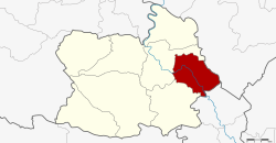
Sapphaya district
|
Sapphaya สรรพยา |
|
|---|---|
| Province: | Chai Nat |
| Surface: | 228.27 km² |
| Residents: | 43,435 (2013) |
| Population density : | 199.1 U / km² |
| ZIP : | 17150 |
| Geocode : | 1804 |
| map | |

|
|
Amphoe Sapphaya ( Thai : อำเภอ สรรพยา ) is a district ( Amphoe - administrative district) in the eastern part of the province of Chai Nat . The Chai Nat Province is located in the northern part of the central region of Thailand .
geography
Neighboring districts (from the southwest clockwise) the Amphoe Sankhaburi , Mueang Chai Nat province Chai Nat, Amphoe Takhli the Nakhon Sawan and Amphoe In Buri the province Sing Buri .
administration
Provincial Administration
Amphoe Sapphaya is divided into seven communities ( tambon ) , which in turn are divided into 55 village communities ( muban ) .
| No. | Surname | Thai | Muban | Pop. |
|---|---|---|---|---|
| 1. | Sapphaya | สรรพยา | 7th | 6,873 |
| 2. | Taluk | ต ลุก | 12 | 8,830 |
| 3. | Khao Kaeo | เขา แก้ว | 6th | 3,186 |
| 4th | Pho Nang Dam Tok | โพ นางดำ ตก | 6th | 6,678 |
| 5. | Pho Nang Dam Ok | โพ นางดำ ออก | 8th | 5,424 |
| 6th | Bang Luang | บาง หลวง | 7th | 5,791 |
| 7th | Has Asa | หาด อาษา | 9 | 6,653 |
Local administration
There are eight municipalities with "small town" status ( Thesaban Tambon ) in the district:
- Chao Phraya (Thai: เทศบาล ตำบล เจ้าพระยา ) consisting of parts of the Tambon Sapphaya.
- Taluk (Thai: เทศบาล ตำบล ต ลุก ) consisting of the complete tambon taluk.
- Pho Nang Dam Tok (Thai: เทศบาล ตำบล โพ นางดำ ตก ) consisting of parts of the tambon Pho Nang Dam Tok.
- Pho Nang Dam Ok (Thai: เทศบาล ตำบล โพ นางดำ ออก ) consisting of the complete tambon Pho Nang Dam Ok.
- Hat Asa (Thai: เทศบาล ตำบล หาด อาษา ) consisting of the complete Tambon Hat Asa.
- Pho Phithak (Thai: เทศบาล ตำบล โพธิ์ พิทักษ์ ) consisting of parts of the Tambon Pho Nang Dam Tok.
- Sapphaya (Thai: เทศบาล ตำบล สรรพยา ) consisting of parts of the Tambon Sapphaya.
- Bang Luang (Thai: เทศบาล ตำบล บาง หลวง ) consisting of the complete tambon Bang Luang.
There is also a " tambon administration organizations " ( องค์การ บริหาร ส่วน ตำบล - Tambon Administrative Organizations, TAO)
- Khao Kaeo (Thai: องค์การ บริหาร ส่วน ตำบล เขา แก้ว ) consisting of the complete Tambon Khao Kaeo.
Individual evidence
- ↑ 2013 population statistics ( Thai ) Department of Provincial Administration. Retrieved August 25, 2014.
Web links
Coordinates: 15 ° 8 ′ N , 100 ° 15 ′ E
