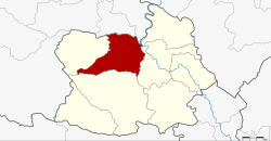
Amphoe Wat Sing
|
Wat Sing วัดสิงห์ |
|
|---|---|
| Province: | Chai Nat |
| Surface: | 315.318 km² |
| Residents: | 26,172 (2013) |
| Population density : | 83.5 U / km² |
| ZIP : | 17120 |
| Geocode : | 1803 |
| map | |

|
|
Amphoe Wat Sing ( Thai : อำเภอ วัดสิงห์ ) is a district ( amphoe - administrative district) in the northern part of the province of Chai Nat . The Chai Nat Province is located in the northern part of the central region of Thailand .
geography
Neighboring districts (clockwise from northeast): the Amphoe Manorom , Mueang Chai Nat , Hankha and Nong Mamong of the Province of Chai Nat and the Amphoe Nong Khayang and Mueang Uthai Thani of the Province of Uthai Thani .
General
Thanks to the two rivers Mae Nam Chao Phraya and Mae Nam Tha Chin (Tha Chin River), the region around Wat Sing is very fertile. The rice farmers in Wat Sing can harvest rice up to three times a year. In addition to rice, the province is also known for the cultivation of pomelos (Thai: ส้ม โอ - Som-O). Sugar cane ( ต้น อ้อย - Ton-Oi) is planted where less water is available . Since Wat Sing is located directly on the rivers, the population has to reckon with floods again and again. Smaller floods occur every few years, but the flood of the century in 2011, which affected almost the entire country, was extreme.
Attractions
One of the sights of Wat Sing is the Buddhist temple ( Wat ) Wat Pak Khlong Makham Thao ( วัด ปาก คลอง มะขาม เฒ่า ), which is located directly on the Chao Phraya River. The weekly markets which take place on Monday, Tuesday and Friday are also recommended. Bicycle tours along rice fields and the Chao Phraya River are also very popular. Thanks to the numerous rivers and quarry ponds, people like to fish here.
administration
Provincial Administration
Wat Sing County is divided into seven tambon ("subdistricts" or "parishes"), which are further subdivided into 47 Muban ("villages").
| No. | Surname | Thai | Muban | Pop. |
|---|---|---|---|---|
| 1. | Wat Sing | วัดสิงห์ | - | 3,705 |
| 2. | Makham Thao | มะขาม เฒ่า | 11 | 5,279 |
| 3. | Nong Noi | หนอง น้อย | 8th | 3,773 |
| 4th | Nong Bua | หนองบัว | 5 | 2,860 |
| 6th | Nong Khun | หนอง ขุ่น | 8th | 3,603 |
| 7th | Bo Rae | บ่อแร่ | 7th | 2,506 |
| 11. | Wang Man | วัง หมัน | 8th | 4,446 |
Local administration
There are three municipalities with "small town" status ( Thesaban Tambon ) in the district:
- Nong Noi (Thai: เทศบาล ตำบล หนอง น้อย ) consisting of the complete Tambon Nong Noi.
- Nong Khun (Thai: เทศบาล ตำบล หนอง ขุ่น ) consisting of the complete tambon Nong Khun.
- Wat Sing (Thai: เทศบาล ตำบล วัดสิงห์ ) consisting of the complete tambon Wat Sing.
There are also four " tambon administration organizations " ( องค์การ บริหาร ส่วน ตำบล - Tambon Administrative Organizations, TAO)
- Makham Thao (Thai: องค์การ บริหาร ส่วน ตำบล มะขาม เฒ่า ) consisting of the complete tambon Makham Thao.
- Nong Bua (Thai: องค์การ บริหาร ส่วน ตำบล หนองบัว ) consisting of the complete Tambon Nong Bua.
- Bo Rae (Thai: องค์การ บริหาร ส่วน ตำบล บ่อแร่ ) consisting of the complete tambon Bo Rae.
- Wang Man (Thai: องค์การ บริหาร ส่วน ตำบล วัง หมัน ) consisting of the complete tambon Wang Man.
Individual evidence
- ↑ 2013 population statistics ( Thai ) Department of Provincial Administration. Retrieved August 25, 2014.
Web links
Coordinates: 15 ° 15 ' N , 100 ° 2' E
