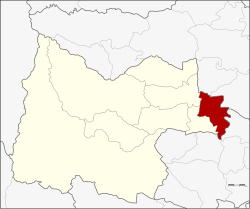
Amphoe Mueang Uthai Thani
|
Mueang Uthai Thani เมือง อุทัยธานี |
|
|---|---|
| Province: | Uthai Thani |
| Surface: | 250.1 km² |
| Residents: | 51,330 (2012) |
| Population density : | 210.3 U / km² |
| ZIP : | 61000 |
| Geocode : | 6101 |
| map | |

|
|
Amphoe Mueang Uthai Thani ( Thai อำเภอ เมือง อุทัยธานี ) is a district ( Amphoe - Administrative District) in the northeast of the Uthai Thani Province . The Uthai Thani Province is located in the northern region of Thailand .
geography
Neighboring counties (clockwise from west): Nong Khayang and Thap Than of Uthai Thani Province, Krok Phra and Phayuha Khiri of Nakhon Sawan Province, and Manorom and Wat Sing of Chai Nat Province .
Economy and Importance
A five-star OTOP product is made in Amphoe Mueang Uthai Thani : incense sticks and mosquito repellents .
Attractions
- Wat Sangkat Rattana Khiri ( วัด สั ง กั สรัตน คีรี ) - Buddhist temple complex ( Wat ) at the foot of Khao Sakaekrang with a large Buddha statue in Sukhothai style. It was made at the time of King Phra Phutthayotfa Chulalok ( Rama I ) and is said to contain a relic in the head.
- Wat Ubosatharam (also: Wat Bot; วัด อุ โปส ถา ราม ) - on the eastern bank of Maenam Sakaekrang, with wall paintings from the Rattanakosin period in Ubosot and Viharn . Also worth seeing are the old Bai Sema , the boundary stones of the Ubosot.
- Wat Chantharam ( วัด จัน ทา ราม ) also: Wat Tha Soong - Buddhist temple in Tambon Tha Sung with an ubosot lined with mirror mosaic
administration
Provincial Administration
Amphoe Mueang Uthai Thani is divided into 14 communities ( Tambon ) , which are further divided into 86 villages ( Muban ) .
| No. | Surname | Thai | Muban | Pop. | No. | Surname | Thai | Muban | Pop. | |
|---|---|---|---|---|---|---|---|---|---|---|
| 1. | Uthai May | อุทัย ใหม่ | - | 15,838 | 8th. | Nong Kae | หนอง แก | 6th | 2,072 | |
| 2. | Nam Suem | น้ำซึม | 7th | 6,640 | 9. | Non Lek | โนน เหล็ก | 6th | 1,395 | |
| 3. | Sakae Krang | สะแก กรัง | 8th | 4,945 | 10. | Nong Tao | หนอง เต่า | 6th | 1,716 | |
| 4th | Don Khwang | ดอน ขวาง | 7th | 3,104 | 11. | Nong Phai Baen | หนองไผ่ แบน | 6th | 2,333 | |
| 5. | Has Thanong | หาด ทน ง | 6th | 1,975 | 12. | Nong Phang Kha | หนอง พัง ค่า | 6th | 1,690 | |
| 6th | Ko Thepho | เกาะ เทโพ | 6th | 2,506 | 13. | Thung Yai | ทุ่งใหญ่ | 5 | 908 | |
| 7th | Tha Sung | ท่า ซุง | 8th | 3,874 | 14th | Noen Chaeng | เนิน แจง | 9 | 2,334 |
Local administration
There are two municipalities with "small town" status ( Thesaban Tambon ) in the district:
- Mueang Uthai Thani ( เทศบาล เมือง อุทัยธานี ) consists of the whole Tambon Uthai Mai.
- Hat Thanong ( เทศบาล ตำบล หาด ทน ง ) consists of the whole tambon Hat Thanong.
There are also ten “ Tambon Administrative Organizations ” ( องค์การ บริหาร ส่วน ตำบล - Tambon Administrative Organizations, TAO) for the tambon in the county that do not belong to any city.
Individual evidence
- ↑ Page about the 5-star OTOP product (in English)
- ↑ Population statistics 2012 . Department of Provincial Administration. Retrieved July 25, 2014.
- ^ Website of Tha Sung (in Thai)
Web links
Coordinates: 15 ° 23 ' N , 100 ° 1' E