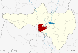
Amphoe Krok Phra
|
Krok Phra โกรกพระ |
|
|---|---|
| Province: | Nakhon Sawan |
| Surface: | 297.194 km² |
| Residents: | 36.003 (2013) |
| Population density : | 122.7 U / km² |
| ZIP : | 60170 |
| Geocode : | 6002 |
| map | |

|
|
Amphoe Krok Phra ( Thai : อำเภอ โกรกพระ ) is a district ( amphoe - administrative district) in the province of Nakhon Sawan . Nakhon Sawan Province is located in the southern part of the northern region of Thailand .
geography
Neighboring districts (clockwise from the north): the Amphoe Mueang Nakhon Sawan and Phayuha Khiri of the province of Nakhon Sawan and the Amphoe Mueang Uthai Thani , Thap Than and Sawang Arom of the province of Uthai Thani .
history
Krok Phra County was originally called Noen Sala. However, since the district administration was in a bad traffic location, the government moved the administration to Ban Krok Phra on the west bank of the Mae Nam Chao Phraya ( Chao Phraya River ) in 1899 . The name of the district has been changed accordingly.
Ban Krok Phra was originally called Ban Krok , which means village on the precipice . A local legend tells of an old couple who wanted to bring a large Buddha statue from Sukhothai to Ayutthaya on a raft . When the raft arrived in Ban Krok, it broke and the statue sank in the river. Since then, the inhabitants have called their village Ban Krok Phra (Phra, พระ , short for: Buddha statue ).
administration
Provincial Administration
The district of Krok Phra is divided into nine tambon ("sub-districts" or "municipalities"), which are further subdivided into 65 muban ("villages").
| No. | Surname | Thai | Muban | Pop. |
|---|---|---|---|---|
| 1. | Krok Phra | โกรกพระ | 8th | 8,641 |
| 2. | Yang Tan | ยาง ตาล | 9 | 4,226 |
| 3. | Bang Mafo | บาง มะฝ่อ | 6th | 4,248 |
| 4th | Bang Pramung | บาง ประ มุง | 8th | 5,090 |
| 5. | Well sound | นากลาง | 8th | 3,024 |
| 6th | Sala Daeng | ศาลาแดง | 5 | 2,862 |
| 7th | Noen Kwao | เนิน กว้าว | 7th | 2,979 |
| 8th. | Noen Sala | เนิน ศาลา | 8th | 2,999 |
| 9. | Has sung | หาด สูง | 6th | 1.934 |
Local administration
There are three municipalities with "small town" status ( Thesaban Tambon ) in the district:
- Bang Mafo (Thai: เทศบาล ตำบล บาง มะฝ่อ ) consisting of the complete Tambon Bang Mafo.
- Krok Phra (Thai: เทศบาล ตำบล โกรกพระ ) consisting of parts of the Tambon Krok Phra.
- Bang Pramung (Thai: เทศบาล ตำบล บาง ประ มุง ) consisting of the complete Tambon Bang Pramung.
In addition, there are seven " Tambon Administration Organizations " ( องค์การ บริหาร ส่วน ตำบล - Tambon Administrative Organizations, TAO)
- Krok Phra (Thai: องค์การ บริหาร ส่วน ตำบล โกรกพระ ) consisting of parts of the Tambon Krok Phra.
- Yang Tan (Thai: องค์การ บริหาร ส่วน ตำบล ยาง ตาล ) consisting of the complete Tambon Yang Tan.
- Na Klang (Thai: องค์การ บริหาร ส่วน ตำบล นากลาง ) consisting of the complete Tambon Na Klang.
- Sala Daeng (Thai: องค์การ บริหาร ส่วน ตำบล ศาลาแดง ) consisting of the complete Tambon Sala Daeng.
- Noen Kwao (Thai: องค์การ บริหาร ส่วน ตำบล เนิน กว้าว ) consisting of the complete tambon Noen Kwao.
- Noen Sala (Thai: องค์การ บริหาร ส่วน ตำบล เนิน ศาลา ) consisting of the complete Tambon Noen Sala.
- Hat Sung (Thai: องค์การ บริหาร ส่วน ตำบล หาด สูง ) consisting of the complete Tambon Hat Sung.
Individual evidence
- ↑ 2013 population statistics ( Thai ) Department of Provincial Administration. Retrieved October 28, 2014.
Web links
Coordinates: 15 ° 33 ' N , 100 ° 4' E
