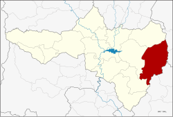
Phaisali district
|
Phaisali ไพศาลี |
|
|---|---|
| Province: | Nakhon Sawan |
| Surface: | 979.5 km² |
| Residents: | 72,394 (2013) |
| Population density : | 72.3 U / km² |
| ZIP : | 60220 |
| Geocode : | 6009 |
| map | |

|
|
Amphoe Phaisali ( Thai : อำเภอ ไพศาลี ) is a district ( Amphoe - administrative district) in the eastern part of the province of Nakhon Sawan . Nakhon Sawan Province is located in the southern part of the northern region of Thailand .
geography
Neighboring districts are (from north clockwise): Amphoe Nong Bua province Nakhon Sawan, the Amphoe Bueng Sam Phan and Wichian Buri the Phetchabun province , the Amphoe Khok Charoen and Nong Muang the province of Lop Buri and Amphoe Tak Fa and Tha Tako again in Nakhon Sawan.
history
Phaisali is a very old city, as evidenced by remains of the Khmer Empire in the Tambon Samrong Chai. In the Tambon Pho Prasat and Na Khom even ancient burial places have been found, which could date from the time of Ban Chiang .
The district of Phaisali was initially set up as a "branch district" ( King Amphoe ) on January 1, 1962 , by separating the Tambon Samrong Chai, Khok Duea and Takhro from the Amphoe Tha Tako . On July 27, 1965, he received full amphoe status.
administration
Provincial Administration
Phaisali County is divided into eight tambon ("subdistricts" or "parishes"), which are further subdivided into 101 Muban ("villages").
| No. | Surname | Thai | Muban | Pop. |
|---|---|---|---|---|
| 1. | Khok Duea | โคก เดื่อ | 9 | 7.143 |
| 2. | Samrong Chai | สำโรง ชัย | 21st | 11,412 |
| 3. | Wang Nam Lat | วัง น้ำ ลัด | 10 | 7,713 |
| 4th | Takhro | ตะคร้อ | 18th | 11,668 |
| 5. | Pho Prasat | โพธิ์ ประสาท | 13 | 6,772 |
| 6th | Wang Khoi | วัง ข่อย | 11 | 8,270 |
| 7th | Na Khom | นา ขอ ม | 11 | 6,049 |
| 8th. | Phaisali | ไพศาลี | 8th | 13,367 |
Local administration
There is one municipality with "small town" status ( Thesaban Tambon ) in the district:
- Phaisali (Thai: เทศบาล ตำบล ไพศาลี ) consisting of the parts of the Tambon Khok Duea, Phaisali.
In addition, there are eight " tambon administration organizations " ( องค์การ บริหาร ส่วน ตำบล - Tambon Administrative Organizations, TAO)
- Khok Duea (Thai: องค์การ บริหาร ส่วน ตำบล โคก เดื่อ ) consisting of parts of the tambon Khok Duea.
- Samrong Chai (Thai: องค์การ บริหาร ส่วน ตำบล สำโรง ชัย ) consisting of the complete Tambon Samrong Chai.
- Wang Nam Lat (Thai: องค์การ บริหาร ส่วน ตำบล วัง น้ำ ลัด ) consisting of the complete tambon Wang Nam Lat.
- Takhro (Thai: องค์การ บริหาร ส่วน ตำบล ตะคร้อ ) consisting of the complete tambon takhro.
- Pho Prasat (Thai: องค์การ บริหาร ส่วน ตำบล โพธิ์ ประสาท ) consisting of the complete tambon Pho Prasat.
- Wang Khoi (Thai: องค์การ บริหาร ส่วน ตำบล วัง ข่อย ) consisting of the complete tambon Wang Khoi.
- Na Khom (Thai: องค์การ บริหาร ส่วน ตำบล นา ขอ ม ) consisting of the complete tambon Na Khom.
- Phaisali (Thai: องค์การ บริหาร ส่วน ตำบล ไพศาลี ) consisting of parts of the Tambon Phaisali.
Individual evidence
- ↑ ประกาศ กระทรวง มหาดไทย เรื่อง การ แบ่ง ท้องที่ ตั้ง เป็น กิ่ง อำเภอ Royal Gazette Volume 79, Issue 4 ง of January 9, 1962, pp. 32–33 (in Thai)
- ↑ พระราชกฤษฎีกา ตั้ง อำเภอ ศรีสวัสดิ์ อำเภอ สังขละบุรี อำเภอ ท่าคันโท อำเภอ ดอกคำใต้ อำเภอ แม่ใจ อำเภอ จุน อำเภอ ขามทะเลสอ อำเภอ ไพศาลี อำเภอ ท่าวังผา อำเภอ บ้านกรวด อำเภอ เด่นชัย เด่นชัย อำเภอ ปทุมรัตต์ อำเภอ กะเปอร์ อำเภอ อากาศอำนวย อำเภอ ดอนเจดีย์ อำเภอ จอมพระ และ อำเภอ สามโก้ พ.ศ. ๒๕๐๘ Royal Gazette Volume 81, Ed. 49 ก July 27, 1965, pp. 565–569 (in Thai)
- ↑ 2013 population statistics ( Thai ) Department of Provincial Administration. Retrieved October 28, 2014.
Web links
Coordinates: 15 ° 36 ' N , 100 ° 39' E
