Mae Poen district
|
Mae Poen แม่ เปิ น |
|
|---|---|
| Province: | Nakhon Sawan |
| Surface: | 260.2 km² |
| Residents: | 20,621 (2013) |
| Population density : | 75.8 U / km² |
| ZIP : | 60150 |
| Geocode : | 6014 |
| map | |

|
|
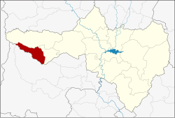
Amphoe Mae Poen ( Thai : อำเภอ แม่ เปิ น ) is a district ( Amphoe - administrative district) in the western part of Nakhon Sawan Province . Nakhon Sawan Province is located in the southern part of the northern region of Thailand .
geography
Neighboring districts are (from north clockwise): Amphoe Mae Wong and Chum Ta Bong of Nakhon Sawan, the Amphoe Lan Sak and Ban Rai of Uthai Thani province and Amphoe Umphang of Tak Province .
history
Mae Poen County was initially set up on July 15, 1996 as a "Branch County" ( King Amphoe ) by separating Tambon Mae Poen from Lat Yao district .
With the publication in the Royal Gazette "Issue 124 chapter 46" on August 24, 2007 Mae Poen officially received full amphoe status.
administration
Provincial Administration
The district of Mae Poen is divided into a tambon ("subdistricts" or "municipalities"), which are further subdivided into 24 muban ("villages").
| No. | Surname | Thai | Muban | Pop. |
|---|---|---|---|---|
| 1. | Mae Poen | แม่ เปิ น | 24 | 20,621 |
Local administration
In the district there is a " Tambon Administration Organization " ( องค์การ บริหาร ส่วน ตำบล - Tambon Administrative Organization, TAO)
- Mae Poen (Thai: องค์การ บริหาร ส่วน ตำบล แม่ เปิ น ) consisting of the complete tambon Mae Poen.
Individual evidence
- ↑ ประกาศ กระทรวง มหาดไทย เรื่อง แบ่ง เขต ท้องที่ อำเภอ ลาดยาว จังหวัด นครสวรรค์ ตั้ง เป็น กิ่ง อำเภอ แม่ เปิ น Royal Gazette, Vol. 113, Issue 18 ง Special ( พิเศษ ) from June 15, 1996, p. 15 (in Thai)
- ↑ พระราชกฤษฎีกา ตั้ง อำเภอ ฆ้องชัย ... และ อำเภอ เหล่า เสือ โก้ ก พ.ศ. ๒๕๕๐ Royal Gazette, Vol. 124, Issue 46 ก , pp. 14–21 of August 24, 2007 (in Thai)
- ↑ 2013 population statistics ( Thai ) Department of Provincial Administration. Retrieved October 28, 2014.
Web links
Coordinates: 15 ° 39 ′ N , 99 ° 28 ′ E
