Umphang district
|
Umphang อุ้มผาง |
|
|---|---|
| Province: | Tak |
| Surface: | 4,325.4 km² |
| Residents: | 29,043 (2012) |
| Population density : | 6 U / km² |
| ZIP : | 63170 |
| Geocode : | 6308 |
| map | |

|
|
Amphoe Umphang ( Thai อำเภอ อุ้มผาง ; pronunciation: [ʔûmpʰǎːŋ] ) is a district ( Amphoe - administrative district) in the province of Tak . The Tak Province is located in the northern region of Thailand .
geography
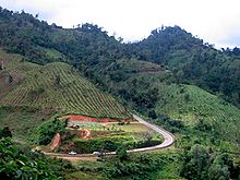
Umphang County is located in the extreme south of Tak Province and borders the Kamphaeng Phet , Nakhon Sawan , Uthai Thani and Kanchanaburi provinces and Burma to the west . This makes Umphang the district with the most diverse borders of the Tak Province. It is also the largest in area and at the same time the most sparsely populated of Thailand's administrative districts.
The neighboring amphoe, seen from the north in a clockwise direction, is Phop Phra in Tak Province, Amphoe Khlong Lan and Pang Sila Thong in Kamphaeng Phet Province , Amphoe Mae Wong and Mae Poen in Nakhon Sawan Province , Amphoe Ban Rai in the Uthai Thani province and Amphoe Thong Pha Phum and Sangkhla Buri the Kanchanaburi province . To the west, behind a long, mountainous borderline, lies the Kayin State in Burma .
Due to its mountainous location, Umphang is one of the least developed areas in the country; therefore it was also used as a retreat by communist insurgents in the 1960s and 1970s . Umphang is separated from the other parts of Tak Province by the Thanon Thongchai Mountains ( ทิว เขา ถนน ธงชัย ). The south of the county is part of the Thung Yai Naresuan Wildlife Sanctuary , while the central area around Umphang is part of the Umphang Wildlife Sanctuary . To the east is the Mae Wong National Park , which is located in the provinces of Tak and Kamphaeng Phet. The Khlong Lan National Park in Kamphaeng Phet is even further to the east . The Khao Kachoela (also Khao Khiao, "Green Mountain") in Amphoe Umphang is one of the highest mountains in Thailand at 2152 m.
The river Klong ( แม่น้ำ กลอง ), which has its source here and continues south to Kanchanaburi Province, is an important waterway in the Amphoe .
Amphoe Umphang can only be reached by one road: from the north Amphoe Phop Phra, Tak Province. In all other directions the area is surrounded by high mountains and inaccessible.
population
Most of the inhabitants of Umphang are descended from the Thai hill tribe and mostly belong to the Karen people . In fact, the Karen settled here before the Thai , so many place names come from their language.
history
Umphang was established in 1898 as Amphoe Mae Khlong ( อำเภอ แม่ กลอง ) in Uthai Thani Province . In 1906 the amphoe was renamed Umphang and came to Kamphaeng Phet Province . On January 1, 1926, Umphang became part of Tak Province and the status of the amphoe was changed to a subdistrict ( King Amphoe ) before it was upgraded to a full amphoe again in 1959.
Attractions
- Thi Lo Su Waterfall ( น้ำตก ที ล อ ซู ) - the largest waterfall in Thailand
- Thi Lo Dscho waterfall ( น้ำตก ที ล อ จ่อ )
- Sai Rung Waterfall ( น้ำตก สายรุ้ง )
- Thi Lo Le waterfall ( น้ำตก ที ล อ เล )
administration
Provincial Administration
Amphoe Umphang consists of 6 subdistricts ( tambon ), which are further divided into 38 villages ( muban ).
| No. | Surname | Thai name | Villages | Residents |
|---|---|---|---|---|
| 1. | Umphang | อุ้มผาง | 6th | 4,394 |
| 2. | Nong Luang | หนอง หลวง | 4th | 2.152 |
| 3. | Mokro | โม โก ร | 7th | 6.236 |
| 4th | Mae Chan | แม่จัน | 12 | 12,188 |
| 5. | Mae Lamung | แม่ ละ มุ้ง | 5 | 1,691 |
| 6th | Mae Klong | แม่ กลอง | 4th | 2,382 |
Local administration
There are three small towns ( Thesaban Tambon ) in the county:
- Umphang ( เทศบาล ตำบล อุ้มผาง ) consists of parts of the tambon umphang,
- Mae Chan ( เทศบาล ตำบล แม่จัน ) consists of the entire tambon Mae Chan,
- Mae Klong ( เทศบาล ตำบล แม่ กลอง ) consists of parts of the Tambon Nong Luang and the entire Tambon Mae Klong.
There are also two “Tambon Administrative Organizations” (TAO, องค์การ บริหาร ส่วน ตำบล - administrative organizations) for the tambon in the district that do not belong to any city.
Individual evidence
- ↑ ประกาศ กระทรวง มหาดไทย เรื่อง ยุบ แยก และ ตั้ง อำเภอ ใน มณฑล นครสวรรค์ . In: Royal Gazette . 42, No. 0 ก , January 17, 1926, pp. 260-262. .
- ↑ พระราชกฤษฎีกา ตั้ง อำเภอ อุ้มผาง พ.ศ. ๒๕๐๒ . In: Royal Gazette . 76, No. 50 ก , May 5, 1959, pp. 108-110. .
- ↑ Population statistics 2012 . Department of Provincial Administration. Retrieved June 25, 2014.
Web links
- More details on Amphoe Umphang from amphoe.com (in Thai)
- History of Umphang , Provincial Administration Page (in Thai; last accessed June 15, 2014)
Coordinates: 16 ° 1 ' N , 98 ° 52' E


