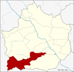
Amphoe Pang Sila Thong
|
Pang Sila Thong ปาง ศิลา ทอง |
|
|---|---|
| Province: | Kamphaeng Phet |
| Surface: | 480.5 km² |
| Residents: | 30,490 (2013) |
| Population density : | 64 U / km² |
| ZIP : | 62120 |
| Geocode : | 6209 |
| map | |

|
|
Amphoe Pang Sila Thong ( Thai : อำเภอ ปาง ศิลา ทอง ) is a district ( Amphoe - administrative district) in the southwest of Kamphaeng Phet Province . The Kamphaeng Phet Province is located in the northern region of Thailand .
geography
The neighboring Amphoe are seen from the north: Khlong Lan , Khlong Khlung and Khanu Woralaksaburi in Kamphaeng Phet Province, and Amphoe Mae Wong in Nakhon Sawan Province and Amphoe Umphang in Tak Province .
In this district lies the northern part of the Mae Wong National Park .
history
Pang Sila Thong was set up on May 31, 1993 initially as a “branch circle ” ( King Amphoe ) by splitting off the Tambon Pang Ta Wai, Hin Dat and Pho Thong from the Khlong Khlung district. On October 11, 1997, the subdistrict was promoted to Amphoe.
The name Pang Sila Thong stands for the three tambon that make up the county - Pang for Pang Ta Wai, Sila for Hin Dat and Thong for Pho Thong.
administration
Provincial Administration
Pang Sila Thong County is divided into three tambon ("subdistricts" or "parishes"), which are further subdivided into 42 muban ("villages").
| No. | Surname | Thai | Muban | Pop. |
|---|---|---|---|---|
| 1. | Pho Thong | โพธิ์ทอง | 17th | 11,680 |
| 2. | Hin Dat | หิน ดา ต | 14th | 10,510 |
| 3. | Pang Ta Wai | ปาง ตา ไว | 11 | 8,300 |
Local administration
There are no cities ( thesaban ) in the district.
In the district there are three " tambon administration organizations " ( องค์การ บริหาร ส่วน ตำบล - Tambon Administrative Organizations, TAO)
- Pho Thong (Thai: องค์การ บริหาร ส่วน ตำบล โพธิ์ทอง ) consisting of the complete Tambon Pho Thong.
- Hin Dat (Thai: องค์การ บริหาร ส่วน ตำบล หิน ดา ต ) consisting of the complete tambon Hin Dat.
- Pang Ta Wai (Thai: องค์การ บริหาร ส่วน ตำบล ปาง ตา ไว ) consisting of the complete tambon Pang Ta Wai.
Individual evidence
- ↑ ประกาศ กระทรวง มหาดไทย เรื่อง แบ่ง เขต ท้องที่ อำเภอ คลองขลุง จังหวัด กำแพงเพชร ตั้ง เป็น กิ่ง อำเภอ ปาง ศิลา ทอง Royal Gazette, Volume 110, Edition 74 ง of June 8, 1993, p. 14 (in Thai)
- ↑ พระราชกฤษฎีกา ตั้ง อำเภอ หนอง ปรือ อำเภอ ห้วย กระเจา อำเภอ ทราย ทอง วัฒนา อำเภอ ปาง ศิลา ทอง อำเภอ เนิน สง่า อำเภอ นา ทม อำเภอ พระ พรหม อำเภอ แม่ แม่ วงก์ อำเภอ สอง แคว อำเภอ บ้าน ใหม่ ไชย พจน์ อำเภอ ไทย เจริญ อำเภอ กา บัง อำเภอ พยุ จันทร์ อำเภอ เมือง เมือง เมือง เมือง เมือง เมือง เมือง ภู พาน อำเภอ คลอง หอยโข่ง อำเภอ เขา ฉกรรจ์ อำเภอ นา วัง อำเภอ พิบูลย์ รักษ์ และ อำเภอ ทุ่ง ศรี อุดม พ.ศ. ๒๕๔๐ Royal Gazette, Volume 114, Ed. 50 ก of September 26, 1997, pp. 24-27 (in Thai)
- ↑ 2013 population statistics ( Thai ) Department of Provincial Administration. Retrieved October 26, 2014.
Web links
Coordinates: 16 ° 6 ′ N , 99 ° 29 ′ E

