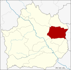
Sai Ngam district
|
Sai Ngam ไทรงาม |
|
|---|---|
| Province: | Kamphaeng Phet |
| Surface: | 448.9 km² |
| Residents: | 51,120 (2013) |
| Population density : | 114.0 U / km² |
| ZIP : | 62150 |
| Geocode : | 6202 |
| map | |

|
|
Amphoe Sai Ngam ( Thai : อำเภอ ไทรงาม ) is a district ( Amphoe - administrative district) in the eastern part of Kamphaeng Phet Province . The Kamphaeng Phet Province is located in the northern region of Thailand .
geography
The district administration of Amphoe Sai Ngam is located about 43 kilometers from the provincial capital.
Neighboring districts (clockwise from south): the Amphoe Sai Thong Watthana , Mueang Kamphaeng Phet , Phran Kratai and Lan Krabue in Kamphaeng Phet Province and the Amphoe Wachirabarami and Sam Ngam in Phichit Province .
history
Sai Ngam County was set up on May 15, 1975, initially as a “branch district” ( King Amphoe ) by spinning off the two tambon Sai Ngam and Nong Khla from Mueang Kamphaeng Phet County. On March 25, 1979, Sai Ngam was finally promoted to Amphoe.
administration
Provincial Administration
Sai Ngam County is divided into seven tambon ("subdistricts" or "parishes"), which are further subdivided into 71 muban ("villages").
| No. | Surname | Thai | Muban | Pop. |
|---|---|---|---|---|
| 1. | Sai Ngam | ไทรงาม | 10 | 9,400 |
| 2. | Nong Khla | หนอง คล้า | 8th | 5,144 |
| 3. | Nong Thong | หนอง ทอง | 10 | 6,755 |
| 4th | Nong Mai Kong | หนอง ไม้ กอง | 10 | 6,779 |
| 5. | Maha Chai | มหาชัย | 12 | 7.202 |
| 6th | Phan Thong | พานทอง | 10 | 7,921 |
| 7th | Nong Mae Taeng | หนอง แม่แตง | 11 | 7,919 |
Local administration
There is one municipality with "small town" status ( Thesaban Tambon ) in the district:
- Sai Ngam (Thai: เทศบาล ตำบล ไทรงาม ) consisting of parts of the tambon Sai Ngam.
In addition, there are seven " Tambon Administration Organizations " ( องค์การ บริหาร ส่วน ตำบล - Tambon Administrative Organizations, TAO)
- Sai Ngam (Thai: องค์การ บริหาร ส่วน ตำบล ไทรงาม ) consisting of parts of the tambon Sai Ngam.
- Nong Khla (Thai: องค์การ บริหาร ส่วน ตำบล หนอง คล้า ) consisting of the complete Tambon Nong Khla.
- Nong Thong (Thai: องค์การ บริหาร ส่วน ตำบล หนอง ทอง ) consisting of the complete Tambon Nong Thong.
- Nong Mai Kong (Thai: องค์การ บริหาร ส่วน ตำบล หนอง ไม้ กอง ) consisting of the complete tambon Nong Mai Kong.
- Maha Chai (Thai: องค์การ บริหาร ส่วน ตำบล มหาชัย ) consisting of the complete Tambon Maha Chai.
- Phan Thong (Thai: องค์การ บริหาร ส่วน ตำบล พานทอง ) consisting of the complete Tambon Phan Thong.
- Nong Mae Taeng (Thai: องค์การ บริหาร ส่วน ตำบล หนอง แม่แตง ) consisting of the complete tambon Nong Mae Taeng.
Individual evidence
- ↑ ประกาศ กระทรวง มหาดไทย เรื่อง แบ่ง ท้องที่ อำเภอ เมือง กำแพงเพชร จังหวัด กำแพงเพชร ตั้ง เป็น กิ่ง อำเภอ ไทรงาม Royal Gazette, Volume 92, Issue 98 ง of May 20, 1975, p. 1249 (in Thai)
- ↑ พระราชกฤษฎีกา ตั้ง อำเภอ หนองกุงศรี อำเภอ ไทรงาม อำเภอ บ้านฝาง อำเภอ อุบลรัตน์ อำเภอ เวียงชัย อำเภอ ดอยเต่า อำเภอ นิคมคำสร้อย อำเภอ นาหว้า อำเภอ เสิงสาง อำเภอ ศรีสาคร อำเภอ บึงสามพัน อำเภอ นาดูน อำเภอ อำเภอ ค้อวัง อำเภอ โพธิ์ชัย อำเภอ อำเภอ เมืองสรวง อำเภอ ปลวกแดง อำเภอ ยางชุมน้อย อำเภอ กาบเชิง อำเภอ สุวรรณคูหา และ อำเภอ กุดข้าวปุ้น พ.ศ. ๒๕๒๒ Royal Gazette, Volume 96, Asg. 42 ก special ( ฉบับ พิเศษ ) from March 25, 1979, pp. 19–24 (in Thai)
- ↑ 2013 population statistics ( Thai ) Department of Provincial Administration. Retrieved October 26, 2014.
Web links
Coordinates: 16 ° 28 ' N , 99 ° 54' E
