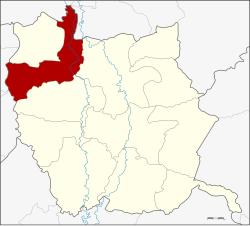
Sam Ngam district
|
Sam Ngam สามง่าม |
|
|---|---|
| Province: | Phichit |
| Surface: | 338.08 km² |
| Residents: | 43,009 (2013) |
| Population density : | 130.4 U / km² |
| ZIP : | 66140, 66220 |
| Geocode : | 6607 |
| map | |

|
|
Amphoe Sam Ngam ( Thai : อำเภอ สามง่าม ) is a district ( amphoe - administrative district) in the northwest of Phichit Province . Phichit Province is located in the southern part of the northern region of Thailand .
geography
Neighboring counties (clockwise from the east): Amphoe Mueang Phichit and Pho Prathap Chang of Phichit Province, Amphoe Bueng Samakkhi , Sai Thong Watthana and Sai Ngam of Kamphaeng Phet Province , Amphoe Wachirabarami also from Phichit Province, and Amphoe Bang Rakam and Bang Krathum of Phitsanulok Province.
history
Sam Ngam was founded on March 1, 1939 and consisted of the tambon Sam Ngam, Rang Nok, Wang Chik, Phai Rop, Ban Na and Noen Po of the Mueang Phichit District , and Kamphaeng Din and Hat Kruat of the Bang Krathum District , Phitsanulok Province , together. In 1943, the tambon Wang Chik and Phai Rop were split off from Sam Ngam and incorporated into Pho Prathap Chang County of Phichit Province.
administration
Provincial Administration
Sam Ngam County is divided into five tambon ("subdistricts" or "parishes"), which are further divided into 79 muban ("villages").
| No. | Surname | Thai | Muban | Pop. |
|---|---|---|---|---|
| 1. | Sam Ngam | สามง่าม | 16 | 9,464 |
| 2. | Kamphaeng Din | กำแพง ดิน | 12 | 5,876 |
| 3. | Rank Nok | รังนก | 12 | 6,199 |
| 6th | Noen Po | เนิน ปอ | 20th | 9,090 |
| 7th | Nong Sano | หนอง โสน | 19th | 12,380 |
Note: The missing numbers (geocodes) refer to the tambon that make up Wachirabarami County today.
Local administration
There are three municipalities with "small town" status ( Thesaban Tambon ) in the district:
- Kamphaeng Din (Thai: เทศบาล ตำบล กำแพง ดิน ) consisting of parts of the Tambon Kamphaeng Din.
- Sam Ngam (Thai: เทศบาล ตำบล สามง่าม ) consisting of parts of the Tambon Sam Ngam.
- Noen Po (Thai: เทศบาล ตำบล เนิน ปอ ) consisting of the complete Noen Po tambon.
There are also four " tambon administration organizations " ( องค์การ บริหาร ส่วน ตำบล - Tambon Administrative Organizations, TAO)
- Sam Ngam (Thai: องค์การ บริหาร ส่วน ตำบล สามง่าม ) consisting of parts of the Tambon Sam Ngam.
- Kamphaeng Din (Thai: องค์การ บริหาร ส่วน ตำบล กำแพง ดิน ) consisting of parts of the Tambon Kamphaeng Din.
- Rang Nok (Thai: องค์การ บริหาร ส่วน ตำบล รังนก ) consisting of the complete tambon Rang Nok.
- Nong Sano (Thai: องค์การ บริหาร ส่วน ตำบล หนอง โสน ) consisting of the complete Tambon Nong Sano.
Individual evidence
- ↑ ประกาศ สำนัก นายกรัฐมนตรี เรื่อง ตั้ง อำเภอ สามง่าม จังหวัด พิจิตร . In: Royal Gazette . 55, No. 0 ง , February 27, 1939, p. 4073.
- ↑ 2013 population statistics ( Thai ) Department of Provincial Administration. Retrieved November 18, 2014.
Web links
Coordinates: 16 ° 31 ' N , 100 ° 12' E
