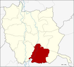
Bang Mun Nak district
|
Bang Mun Nak บางมูลนาก |
|
|---|---|
| Province: | Phichit |
| Surface: | 377.7 km² |
| Residents: | 46,751 (2013) |
| Population density : | 130.5 U / km² |
| ZIP : | 66120, 66210 |
| Geocode : | 6605 |
| map | |

|
|
Amphoe Bang Mun Nak ( Thai : อำเภอ บางมูลนาก ) is a district ( amphoe - administrative district) in the south of Phichit Province . Phichit Province is located in the northern region of Thailand .
geography
Neighboring counties (clockwise from the west): the Amphoe Pho Thale , Taphan Hin , Thap Khlo and Dong Charoen of Phichit Province, and Nong Bua and Chum Saeng of Nakhon Sawan Province .
administration
Provincial Administration
Bang Mun Nak County is divided into ten tambon ("subdistricts" or "parishes"), which are further subdivided into 78 muban ("villages").
| No. | Surname | Thai | Muban | Pop. |
|---|---|---|---|---|
| 1. | Bang Mun Nak | บางมูลนาก | - | 8,800 |
| 2. | Bang Phai | บางไผ่ | 12 | 7.014 |
| 3. | Ho krai | หอ ไกร | 9 | 6.136 |
| 4th | Noen Makok | เนิน มะกอก | 12 | 7,046 |
| 5. | Wang Samrong | วัง สำโรง | 7th | 3,611 |
| 6th | Phum | ภูมิ | 5 | 2,192 |
| 7th | Wang Krot | วัง กรด | 6th | 2,466 |
| 8th. | Huai Khen | ห้วย เข น | 5 | 1,477 |
| 9. | Wang Taku | วัง ตะกู | 12 | 5,400 |
| 14th | Lam Prada | ลำ ประดา | 10 | 2,609 |
Note: The missing numbers (geocodes) refer to the tambon that make up the Dong Charoen district today .
Local administration
There is one commune with "city" status ( Thesaban Mueang ) in the district:
- Bang Mun Nak (Thai: เทศบาล เมือง บางมูลนาก ) consisting of the complete tambon Bang Mun Nak.
There are four municipalities with "small town" status ( Thesaban Tambon ) in the district:
- Bang Phai (Thai: เทศบาล ตำบล บางไผ่ ) consisting of parts of the Tambon Bang Phai.
- Wang Taku (Thai: เทศบาล ตำบล วัง ตะกู ) consisting of parts of the tambon Wang Taku.
- Ho Krai (Thai: เทศบาล ตำบล หอ ไกร ) consisting of the complete tambon Ho Krai.
- Noen Makok (Thai: เทศบาล ตำบล เนิน มะกอก ) consisting of the complete Noen Makok tambon.
In addition, there are six " tambon administration organizations " ( องค์การ บริหาร ส่วน ตำบล - Tambon Administrative Organizations, TAO)
- Bang Phai (Thai: องค์การ บริหาร ส่วน ตำบล บางไผ่ ) consisting of parts of the Tambon Bang Phai.
- Wang Samrong (Thai: องค์การ บริหาร ส่วน ตำบล วัง สำโรง ) consisting of the complete tambon Wang Samrong.
- Phum (Thai: องค์การ บริหาร ส่วน ตำบล ภูมิ ) consisting of the complete Tambon Phum, Huai Khen.
- Wang Krot (Thai: องค์การ บริหาร ส่วน ตำบล วัง กรด ) consisting of the complete tambon Wang Krot.
- Wang Taku (Thai: องค์การ บริหาร ส่วน ตำบล วัง ตะกู ) consisting of parts of the tambon Wang Taku.
- Lam Prada (Thai: องค์การ บริหาร ส่วน ตำบล ลำ ประดา ) consisting of the complete tambon Lam Prada.
traffic
Bang Mun Nak has a station of the Thai state railway on the north runway , the Bangkok with Chiang Mai connects.
Individual evidence
- ↑ 2013 population statistics ( Thai ) Department of Provincial Administration. Retrieved November 17, 2014.
Web links
Coordinates: 16 ° 2 ′ N , 100 ° 23 ′ E
