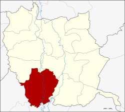
Amphoe Pho Thale
|
Pho Thale โพทะเล |
|
|---|---|
| Province: | Phichit |
| Surface: | 484.4 km² |
| Residents: | 60,650 (2013) |
| Population density : | 127.1 U / km² |
| ZIP : | 66130 |
| Geocode : | 6606 |
| map | |

|
|
Amphoe Pho Thale ( Thai : อำเภอ โพทะเล ) is a district ( Amphoe - administrative district) in the southwest of Phichit Province . Phichit Province is located in the southern part of the northern region of Thailand .
geography
Neighboring counties (clockwise from northwest): the Amphoe Bueng Na Rang , Taphan Hin and Bang Mun Nak of Phichit Province, and Chum Saeng , Kao Liao and Banphot Phisai of Nakhon Sawan Province .
history
The district was originally called Bang Khlan . The administration building was moved from Bang Khlan to Tambon Ban Tan in 1939 . Later that year, Amphoe Bang Khlan was renamed Pho Thale and Tambon Ban Tan was also renamed Pho Thale .
administration
Provincial Administration
The district of Pho Thale is divided into eleven tambon ("sub-districts" or "municipalities"), which are further subdivided into 97 Muban ("villages").
| No. | Surname | Thai | Muban | Pop. |
|---|---|---|---|---|
| 1. | Pho Thale | โพทะเล | 9 | 7,486 |
| 2. | Thai Nam | ท้ายน้ำ | 10 | 5,777 |
| 3. | Thanong | ทะนง | 11 | 7,840 |
| 4th | Tha Bua | ท่า บัว | 13 | 7.233 |
| 5. | Thung Noi | ทุ่ง น้อย | 7th | 3,670 |
| 6th | Tha Khamin | ท่า ขมิ้น | 12 | 5,685 |
| 7th | Tha Sao | ท่า เสา | 9 | 6,033 |
| 8th. | Bang Khlan | บาง คลาน | 6th | 3,835 |
| 11. | Tha Nang | ท่า นั่ง | 6th | 3,910 |
| 12. | Ban Noi | บ้าน น้อย | 6th | 3,715 |
| 13. | Wat Khwang | วัด ขวาง | 8th | 5,466 |
Note: The missing numbers (geocodes) refer to the tambon that make up Bueng Narang County today.
Local administration
There are four municipalities with "small town" status ( Thesaban Tambon ) in the district:
- Thung Noi (Thai: เทศบาล ตำบล ทุ่ง น้อย ) consisting of the complete Tambon Thung Noi.
- Bang Khlan (Thai: เทศบาล ตำบล บาง คลาน ) consisting of the complete tambon Bang Khlan.
- Tha Sao (Thai: เทศบาล ตำบล ท่า เสา ) consisting of the parts of the tambon Tha Khamin, Tha Sao.
- Pho Thale (Thai: เทศบาล ตำบล โพทะเล ) consisting of parts of the Tambon Pho Thale.
In addition, there are nine " tambon administration organizations " ( องค์การ บริหาร ส่วน ตำบล - Tambon Administrative Organizations, TAO)
- Pho Thale (Thai: องค์การ บริหาร ส่วน ตำบล โพทะเล ) consisting of parts of the Tambon Pho Thale.
- Thai Nam (Thai: องค์การ บริหาร ส่วน ตำบล ท้ายน้ำ ) consisting of the complete Tambon Thai Nam.
- Thanong (Thai: องค์การ บริหาร ส่วน ตำบล ทะนง ) consisting of the complete Tambon Thanong.
- Tha Bua (Thai: องค์การ บริหาร ส่วน ตำบล ท่า บัว ) consisting of the complete Tambon Tha Bua.
- Tha Khamin (Thai: องค์การ บริหาร ส่วน ตำบล ท่า ขมิ้น ) consisting of parts of the Tambon Tha Khamin.
- Tha Sao (Thai: องค์การ บริหาร ส่วน ตำบล ท่า เสา ) consisting of parts of the Tambon Tha Sao.
- Tha Nang (Thai: องค์การ บริหาร ส่วน ตำบล ท่า นั่ง ) consisting of the complete Tambon Tha Nang.
- Ban Noi (Thai: องค์การ บริหาร ส่วน ตำบล บ้าน น้อย ) consisting of the complete Tambon Ban Noi.
- Wat Khwang (Thai: องค์การ บริหาร ส่วน ตำบล วัด ขวาง ) consisting of the complete tambon Wat Khwang.
Individual evidence
- ↑ ประกาศ กระทรวง มหาดไทย เรื่อง ย้าย ที่ว่าการ อำเภอ บาง คลาน จังหวัด พิจิตร . In: Royal Gazette . 55, No. 0 ง , January 16, 1939, p. 3400.
- ↑ พระราชกฤษฎีกา เปลี่ยน นาม อำเภอ กิ่ง อำเภอ และ ตำบล บาง แห่ง พุทธศักราช ๒๔๘๒ . In: Royal Gazette . 56, No. 0 ก , April 17, 1939, pp. 354-364.
- ↑ 2013 population statistics ( Thai ) Department of Provincial Administration. Retrieved November 17, 2014.
Web links
Coordinates: 16 ° 6 ' N , 100 ° 16' E
