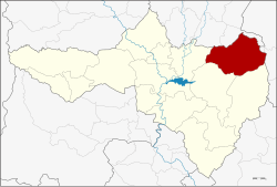
Amphoe Nong Bua
|
Nong Bua หนองบัว |
|
|---|---|
| Province: | Nakhon Sawan |
| Surface: | 819.5 km² |
| Residents: | 70,255 (2013) |
| Population density : | 86.2 U / km² |
| ZIP : | 60110 |
| Geocode : | 6004 |
| map | |

|
|
Amphoe Nong Bua ( Thai : อำเภอ หนองบัว ) is a district ( Amphoe - administrative district) in the northeast of the Nakhon Sawan Province . Nakhon Sawan Province is located in the southern part of the northern region of Thailand .
geography
Neighboring districts (clockwise from the north): Amphoe Bang Mun Nak and Dong Charoen of Phichit Province , Amphoe Chon Daen and Amphoe Bueng Sam Phan of Phetchabun Province, and Amphoe Phaisali , Tha Tako and Chum Saeng of Nakhon Sawan Province.
history
The district of Nong Bua was initially set up as a "branch district" ( King Amphoe ) on January 1, 1948 , by separating some tambons of the Amphoe Chum Saeng , Tha Tako and Bang Mun Nak from the province of Phichit . On June 6, 1956, Nong Bua received full Amphoe status.
education
Nakhon Sawan Rajabhat University is located in Amphoe Nong Bua .
administration
Provincial Administration
Nong Bua County is divided into nine tambon ("subdistricts" or "parishes"), which are further subdivided into 106 muban ("villages").
| No. | Surname | Thai | Muban | Pop. |
|---|---|---|---|---|
| 1. | Nong Bua | หนองบัว | 20th | 15,087 |
| 2. | Nong Klap | หนอง กลับ | 14th | 15,242 |
| 3. | Than Thahan | ธาร ทหาร | 9 | 7,224 |
| 4th | Huai Ruam | ห้วย ร่วม | 11 | 4,352 |
| 5. | Huai Thua Tai | ห้วย ถั่ว ใต้ | 7th | 2,094 |
| 6th | Huai Thua Nuea | ห้วย ถั่ว เหนือ | 9 | 3,437 |
| 7th | Huai Yai | ห้วย ใหญ่ | 6th | 2,734 |
| 8th. | Thung Thong | ทุ่ง ทอง | 14th | 9,301 |
| 9. | Wang Bo | วัง บ่อ | 16 | 10,784 |
Local administration
There is one municipality with "small town" status ( Thesaban Tambon ) in the district:
- Nong Bua (Thai: เทศบาล ตำบล หนองบัว ) consisting of the parts of the Tambon Nong Bua, Nong Klap.
In addition, there are nine " tambon administration organizations " ( องค์การ บริหาร ส่วน ตำบล - Tambon Administrative Organizations, TAO)
- Nong Bua (Thai: องค์การ บริหาร ส่วน ตำบล หนองบัว ) consisting of parts of the Tambon Nong Bua.
- Nong Klap (Thai: องค์การ บริหาร ส่วน ตำบล หนอง กลับ ) consisting of parts of the Tambon Nong Klap.
- Than Thahan (Thai: องค์การ บริหาร ส่วน ตำบล ธาร ทหาร ) consisting of the complete Tambon Than Thahan.
- Huai Ruam (Thai: องค์การ บริหาร ส่วน ตำบล ห้วย ร่วม ) consisting of the complete tambon Huai Ruam.
- Huai Thua Tai (Thai: องค์การ บริหาร ส่วน ตำบล ห้วย ถั่ว ใต้ ) consisting of the complete tambon Huai Thua Tai.
- Huai Thua Nuea (Thai: องค์การ บริหาร ส่วน ตำบล ห้วย ถั่ว เหนือ ) consisting of the complete tambon Huai Thua Nuea.
- Huai Yai (Thai: องค์การ บริหาร ส่วน ตำบล ห้วย ใหญ่ ) consisting of the complete tambon Huai Yai.
- Thung Thong (Thai: องค์การ บริหาร ส่วน ตำบล ทุ่ง ทอง ) consisting of the complete Tambon Thung Thong.
- Wang Bo (Thai: องค์การ บริหาร ส่วน ตำบล วัง บ่อ ) consisting of the complete tambon Wang Bo.
Individual evidence
- ↑ 2013 population statistics ( Thai ) Department of Provincial Administration. Retrieved October 28, 2014.
Web links
Coordinates: 15 ° 52 ' N , 100 ° 35' E
