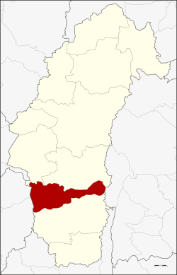
Bueng Sam Phan district
|
Bueng Sam Phan บึงสามพัน |
|
|---|---|
| Province: | Phetchabun |
| Surface: | 489.8 km² |
| Residents: | 71,859 (2013) |
| Population density : | 136 U / km² |
| ZIP : | 67160, 67230 |
| Geocode : | 6708 |
| map | |

|
|
Bueng Sam Phan District ( Thai อำเภอ บึงสามพัน ) is a district ( Amphoe - administrative district) of Phetchabun province . Phetchabun Province is located in the southeastern part of the northern region of Thailand .
geography
Amphoe Bueng Sam Phan is located in the south of Phetchabun Province and, when viewed from the north, borders in a clockwise direction on Amphoe Chon Daen and Nong Phai in Phetchabun Province, Phakdi Chumphon in Chaiyaphum Province , Amphoe Wichian Buri in Phetchabun Province and the Amphoe Phaisali and Nong Bua in the province of Nakhon Sawan .
history
In 1966, after splitting off from Tambon Ban Phot, Amphoe Nong Phai , Tambon Sap Samo Thot was established. On May 15, 1975 the small district ( King Amphoe ) Bueng Sam Phan was formed when the Tambon Sap Mai Daeng, Nong Chaeng and Kan Chu from the Nong Phai district had been relocated here. Bueng Sam Phan is named for the small district's main water source.
Bueng Sam Phan was promoted to a full district (Amphoe) on March 25, 1979.
administration
Provincial Administration
Bueng Sam Phan County is divided into nine tambon ("subdistricts" or "parishes"), which are further subdivided into 123 muban ("villages").
| No. | Surname | Thai | Muban | Pop. |
|---|---|---|---|---|
| 1. | Sap Samo Thoth | ซับ สมอ ทอด | 9 | 11,377 |
| 2. | Sap Mai Daeng | ซับ ไม้แดง | 15th | 7,573 |
| 3. | Nong Chaeng | หนอง แจง | 18th | 7,605 |
| 4th | Kanchu | กัน จุ | 19th | 13,038 |
| 5. | Wang Phikun | วัง พิกุล | 16 | 9,974 |
| 6th | Phaya Wang | พญา วัง | 16 | 4,985 |
| 7th | Si Mongkhon | ศรี มงคล | 11 | 4,379 |
| 8th. | Sa Kaeo | สระแก้ว | 9 | 3.216 |
| 9. | Bueng Sam Phan | บึงสามพัน | 10 | 9,712 |
Local administration
There is one municipality with "small town" status ( Thesaban Tambon ) in the district:
- Sap Samo Thot (Thai: เทศบาล ตำบล ซับ สมอ ทอด ) consisting of the parts of the tambon Sap Samo Thot, Bueng Sam Phan.
In addition, there are nine " tambon administration organizations " ( องค์การ บริหาร ส่วน ตำบล - Tambon Administrative Organizations, TAO)
- Sap Samo Thot (Thai: องค์การ บริหาร ส่วน ตำบล ซับ สมอ ทอด ) consisting of parts of the Tambon Sap Samo Thot.
- Sap Mai Daeng (Thai: องค์การ บริหาร ส่วน ตำบล ซับ ไม้แดง ) consisting of the complete Tambon Sap Mai Daeng.
- Nong Chaeng (Thai: องค์การ บริหาร ส่วน ตำบล หนอง แจง ) consisting of the complete Tambon Nong Chaeng.
- Kanchu (Thai: องค์การ บริหารส่วน ตำบล กัน จุ ) consisting of the complete Tambon Kanchu.
- Wang Phikun (Thai: องค์การ บริหารส่วน ตำบล วัง พิกุล ) consisting of the complete tambon Wang Phikun.
- Phaya Wang (Thai: องค์การ บริหาร ส่วน ตำบล พญา วัง ) consisting of the complete tambon Phaya Wang.
- Si Mongkhon (Thai: องค์การ บริหาร ส่วน ตำบล ศรี มงคล ) consisting of the complete tambon Si Mongkhon.
- Sa Kaeo (Thai: องค์การ บริหาร ส่วน ตำบล สระแก้ว ) consisting of the complete Sa Kaeo tambon.
- Bueng Sam Phan (Thai: องค์การ บริหาร ส่วน ตำบล บึงสามพัน ) consisting of parts of the Tambon Bueng Sam Phan.
Individual evidence
- ↑ ประกาศ กระทรวง มหาดไทย เรื่อง แบ่ง ท้องที่ อำเภอ หนองไผ่ จังหวัด เพชรบูรณ์ ตั้ง เป็น กิ่ง อำเภอ บึงสามพัน . In: Royal Gazette . 92, No. 98 ง , May 20, 1975, p. 1248.
- ↑ พระราชกฤษฎีกา ตั้ง อำเภอ หนองกุงศรี อำเภอ ไทรงาม อำเภอ บ้านฝาง อำเภอ อุบลรัตน์ อำเภอ เวียงชัย อำเภอ ดอยเต่า อำเภอ นิคมคำสร้อย อำเภอ นาหว้า อำเภอ เสิงสาง อำเภอ ศรีสาคร อำเภอ บึงสามพัน อำเภอ นาดูน อำเภอ อำเภอ ค้อวัง อำเภอ โพธิ์ชัย อำเภอ อำเภอ เมืองสรวง อำเภอ ปลวกแดง อำเภอ ยางชุมน้อย อำเภอ กาบเชิง อำเภอ สุวรรณคูหา และ อำเภอ กุดข้าวปุ้น พ.ศ. ๒๕๒๒ . In: Royal Gazette . 96, No. 42 ก ฉบับ พิเศษ (special), March 25, 1979, pp. 19-24.
- ↑ 2013 population statistics ( Thai ) Department of Provincial Administration. Retrieved November 3, 2014.
Web links
Coordinates: 15 ° 48 ' N , 100 ° 0' E