
Amphoe Khao Kho
|
Khao Kho เขา ค้อ |
|
|---|---|
| Province: | Phetchabun |
| Surface: | 1,333 km² |
| Residents: | 36,494 (2013) |
| Population density : | 25 U / km² |
| ZIP : | 67270, 67280 |
| Geocode : | 6711 |
| map | |

|
|
Amphoe Khao Kho ( Thai อำเภอ เขา ค้อ ) is a district ( Amphoe - Administrative District) in Phetchabun Province . The Phetchabun Province is located in the northern region of Thailand .
etymology
The name of the district comes from a specific type of palm called Kho ( ค้อ , Livistona speciosa ) in Thai . It is often found here, so the name of the district can also be translated as "Kho palm hill".
geography
Amphoe Khao Kho is almost completely covered by the foothills of the Phetchabun Mountains .
Amphoe Khao Kho is located in the northwest of Phetchabun Province and, when viewed from the east, borders in a clockwise direction with Amphoe Lom Kao , Lom Sak and Mueang Phetchabun in Phetchabun Province, Amphoe Noen Maprang , Wang Thong and Nakhon Thai in Phitsanulok Province and Dan Sai in Loei Province .
history
Khao Kho was formed on August 21, 1984 as a "branch circle" ( King Amphoe ) by spinning off the two tambon Thung Samo and Khaem Son from the Lom Sak district . On July 19, 1991, it was upgraded to an Amphoe.
Between 1965 and 1984 the area of Khao Kho was the scene of military clashes between the Thai army and insurgent communists who wanted to create a retreat in the mountainous landscape.
Culture
In the small village of Thang Daeng (Tambon Khaem Son) there is Wat Phra That Pha Kaeo, a place of prayer and meditation only built in 2004 on a private initiative with unusual, very imaginative shapes and eye-catching colorful mosaics. It was recognized as a Buddhist monastery by the Sangha Council in 2010.
photos
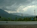
The mountains of Khao Kho in the rain

Landscape in Khao Kho

Si Dit waterfall

Phra Borommathat Chedi, Khao Kho

Wat Phra That Pha Kaeo

Wat Phra That Pha Kaeo


administration
Provincial Administration
The county of Khao Kho is divided into seven tambon ("subdistricts" or "parishes"), which are further divided into 72 muban ("villages").
| No. | Surname | Thai | Muban | Pop. |
|---|---|---|---|---|
| 1. | Thung Samo | ทุ่ง สมอ | 11 | 4.184 |
| 2. | Khaem Son | แคม ป์ สน | 14th | 5,238 |
| 3. | Khao Kho | เขา ค้อ | 14th | 7,444 |
| 4th | Rim Si Muang | ริม สี ม่วง | 6th | 1,367 |
| 5. | Sado Phong | สะเดาะ พง | 5 | 1,590 |
| 6th | Nong Mae Na | หนอง แม่ นา | 10 | 2,916 |
| 7th | Khek Noi | เข็ ก น้อย | 12 | 13,755 |
Local administration
There is one municipality with "small town" status ( Thesaban Tambon ) in the district:
- Khaem Son (Thai: เทศบาล ตำบล แคม ป์ สน ) consisting of the complete Tambon Khaem Son.
There are also four " tambon administration organizations " ( องค์การ บริหาร ส่วน ตำบล - Tambon Administrative Organizations, TAO)
- Thung Samo (Thai: องค์การ บริหาร ส่วน ตำบล ทุ่ง สมอ ) consisting of the complete tambon Thung Samo.
- Khao Kho (Thai: องค์การ บริหาร ส่วน ตำบล เขา ค้อ ) consisting of the complete tambon Khao Kho, Rim Si Muang, Sado Phong.
- Nong Mae Na (Thai: องค์การ บริหาร ส่วน ตำบล หนอง แม่ นา ) consisting of the complete tambon Nong Mae Na.
- Khek Noi (Thai: องค์การ บริหาร ส่วน ตำบล เข็ ก น้อย ) consisting of the complete tambon Khek Noi.
Individual evidence
- ↑ Livistona speciosa Kurz ( Memento of the original from March 4, 2016 in the Internet Archive ) Info: The archive link was inserted automatically and has not yet been checked. Please check the original and archive link according to the instructions and then remove this notice. (in Thai)
- ↑ ประกาศ กระทรวง มหาดไทย เรื่อง แบ่ง เขต ท้องที่ อำเภอ หล่มสัก จังหวัด เพชรบูรณ์ ตั้ง เป็น กิ่ง อำเภอ เขา ค้อ . In: Royal Gazette . 101, No. 118 ง , September 4, 1984, p. 29963.
- ↑ พระราชกฤษฎีกา ตั้ง อำเภอ ทุ่งตะโก อำเภอ พะโต๊ะ อำเภอ เขา ค้อ อำเภอ น้ำ หนาว อำเภอ วัง จันทร์ อำเภอ นาด้วง อำเภอ เต่า ง อย อำเภอ สิงห สิงห นคร อำเภอ พระ สมุทร เจดีย์ และ อำเภอ ลำดวน พ.ศ. ๒๕๓๔ . In: Royal Gazette . 108, No. 107 ก Special ( ฉบับ พิเศษ ), June 19, 1991, pp. 29-33.
- ↑ Information on Wat Phra That Pha Kaeo on the Tourism Authority of Thailand website, accessed July 20, 2014 (in English)
- ↑ 2013 population statistics ( Thai ) Department of Provincial Administration. Retrieved November 3, 2014.
Web links
Coordinates: 16 ° 38 ' N , 101 ° 0' E