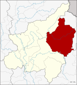
Amphoe Nakhon Thai
|
Nakhon Thai นครไทย |
|
|---|---|
| Province: | Phitsanulok |
| Surface: | 2,220.374 km² |
| Residents: | 86,163 (2012) |
| Population density : | 39 U / km² |
| ZIP : | 65120 |
| Geocode : | 6502 |
| map | |

|
|
Amphoe Nakhon Thai ( Thai นครไทย ) is a district ( Amphoe - Administrative District) in the eastern part of Phitsanulok Province . The Phitsanulok Province is located in the northern region of Thailand .
geography
Amphoe Nakhon Thai is located in the east of Phitsanulok Province and is largely covered by the Phu Hin Rong Kla National Park . Nakhon Thai is located in the middle of the basin of the Mae Nam Nan ( Nan River ), which flows into the Mae Nam Chao Phraya ( Chao Phraya River ). The Mae Nam Khwae Noi also flows through the amphoe, as does the smaller Fia (Thai: ลำน้ำ เฟี้ ย ) and Kaem (Thai: ลำน้ำ แขม ).
Nakhon Thai District borders from the southwest clockwise as seen in Wang Thong and chat Trakan the province of Phitsanulok, the Amphoe Na Haeo and Dan Sai in Loei province as well as in Amphoe Khao Kho of Phetchabun province .
Attractions
There are more than 70 Buddhist temple complexes ( Wat ) in the amphoe .
administration
Provincial Administration
Amphoe Nakhon Thai consists of 11 sub-districts ( tambon ) , which are further divided into 142 villages ( muban ) .
| No. | Surname | Thai | Muban | Pop. |
|---|---|---|---|---|
| 1. | Nakhon Thai | นครไทย | 13 | 10,684 |
| 2. | Nong Kathao | หนอง กะ ท้าว | 26th | 15,917 |
| 3. | Ban Yaeng | บ้าน แยง | 12 | 9,612 |
| 4th | Noen Phoem | เนิน เพิ่ม | 17th | 11,795 |
| 5. | Well Bua | นา บัว | 15th | 7,730 |
| 6th | Nakhon Chum | นคร ชุม | 8th | 3.125 |
| 7th | Nam Kum | น้ำ กุ่ม | 7th | 2,456 |
| 8th. | Yang clone | ยาง โกลน | 10 | 4,976 |
| 9. | Bo Pho | บ่อ โพธิ์ | 14th | 7,029 |
| 10. | Ban Phrao | บ้าน พร้าว | 10 | 6.351 |
| 11. | Huai Hia | ห้วย เฮี้ ย | 10 | 6,488 |
Local administration
There are two small towns ( Thesaban Tambon ) in the district:
- Nakhon Thai (Thai: เทศบาล ตำบล นครไทย ) consists of parts of the Tambon Nakhon Thai,
- Ban Yaeng ( เทศบาล ตำบล บ้าน แยง ) consists of parts of the tambon Ban Yaeng.
There are also nine "Tambon Administrative Organizations" (TAO, องค์การ บริหาร ส่วน ตำบล - administrative organizations) for the tambon in the district that do not belong to any city.
Individual evidence
- ↑ ThinkNet: MapMagic Thailand 2013. Multi-Purposes Bilingual Mapping Software, Bangkok 2013, ThinkNet Co., Ltd., ISBN 978-616-7547-28-2
- ↑ Population statistics 2012 . Department of Provincial Administration. Retrieved June 25, 2014.
Web links
- More information about Amphoe Nakhon Thai bon amphoe.com (in Thai)
- Information about Phu Hin Rong Kla National Park (in English)
Coordinates: 17 ° 6 ′ N , 100 ° 50 ′ E