Amphoe Chat Trakan
|
Chat Trakan ชาติตระการ |
|
|---|---|
| Province: | Phitsanulok |
| Surface: | 1,586.2 km² |
| Residents: | 41,329 (2018) |
| Population density : | 24 U / km² |
| ZIP : | 65170 |
| Geocode : | 6503 |
| map | |

|
|
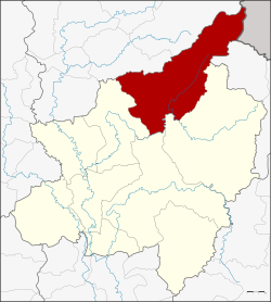
Amphoe Chat Trakan ( Thai อำเภอ ชาติตระการ ) is a district ( Amphoe - Administrative District) in the north of Phitsanulok Province . The Phitsanulok Province is located in the northern region of Thailand .
geography
Amphoe Chat Trakan is located in the far north of the Phitsanulok province and is the only district in the province that has a border with Laos . Chat Trakan is located in the basin of the Mae Nam Nan (Nan River) , which is part of the Mae Nam Chao Phraya watershed . The Mae Nam Khwae Noi (Little Khwae River) and the smaller waters of Cape ( Thai ลำน้ำ คับ ), Phai ( ลำน้ำ ภาค ) and Kleung ( ลำน้ำ คลึง ) flow through the district .
Neighboring districts are seen from Southeast clockwise from Amphoe Na Haeo in Loei province , the Amphoe Nakhon Thai , Wang Thong and Wat Bot of Phitsanulok province and Amphoe Thong Saen Khan and Nam Pat the province of Uttaradit . In the extreme northeast of the district lies the border with the Laotian province of Sayaburi .
history
Chat Trakan was originally a city ( Müang ) just like Nakhon Thai , but it was part of the Nakhon Thai district. Chat Trakan was set up on May 1, 1969, initially as a small district ( King Amphoe ) with the two tambon Chat Trakan and Pa Daeng. On April 1, 1974, Chat Trakan was upgraded to an amphoe.
Amphoe Chat Trakan was the scene of a border conflict between Thailand and Laos from November 1987 to February 1988. The main battle was for the village of Ban Rom Klao, which from the Laotian point of view belongs to the Boten district ( Sainyabuli province ), from the Thai point of view it belongs to the Amphoe Chat Trakan. More than 500 soldiers, mostly Laotians, died.
Attractions
In Chat Trakan there are over 40 active Buddhist temples ( Wat ) .
The Namtok Chat Trakan National Park (Thai: อุทยานแห่งชาติ น้ำตก ชาติตระการ ) is also located here. The 543 km² park was opened on November 2nd, 1987 as the 55th national park in Thailand .
administration
Provincial Administration
Amphoe Chat Trakan consists of six sub-districts ( tambon ) , which are further divided into 72 villages ( muban ) .
| No. | Surname | Thai | Muban | Pop. |
|---|---|---|---|---|
| 1. | Pa Daeng | ป่าแดง | 12 | 8,270 |
| 2. | Chat Trakan | ชาติตระการ | 9 | 4,707 |
| 3. | Suan Miang | สวน เมี่ยง | 10 | 5,761 |
| 4th | Ban dong | บ้าน ดง | 10 | 8,194 |
| 5. | Bo Phak | บ่อ ภาค | 16 | 8,377 |
| 6th | Tha Sakae | ท่า สะแก | 15th | 5.123 |
Local administration
Pa Daeng ( เทศบาล ตำบล ป่าแดง ) is the name of a small town ( Thesaban Tambon ) in the district. It consists of parts of the Tambon Pa Daeng and Tha Sakae.
There are also six "Tambon Administrative Organizations" (TAO, องค์การ บริหาร ส่วน ตำบล - administrative organizations) for the tambon in the district that do not belong to any city.
Individual evidence
- ↑ ประกาศ กระทรวง มหาดไทย เรื่อง แบ่ง ท้องที่ ตั้ง เป็น กิ่ง อำเภอ Royal Gazette, Volume 86, Issue 42 ง of May 13, 1969, p. 1696 (in Thai)
- ↑ พระราชกฤษฎีกา ตั้ง อำเภอ เขาวง อำเภอ เชียงม่วน อำเภอ ดอนตาล อำเภอ ชาติตระการ อำเภอ ภูเรือ อำเภอ เคียน ซา อำเภอ น้ำโสม อำเภอ หนองวัวซอ และ อำเภอ น้ำยืน พ.ศ. ๒๕๑๗ Royal Gazette, Volume 91, Ed. 54 ก ฉบับ พิเศษ (special) from March 28, 1974 pp. 30–33 (in Thai)
- ↑ 500 die in border clashes. In Nicholas Grossman (ed.): Chronicle of Thailand. Headline News since 1946. Edition Didier Millet, Singapore 2009, ISBN 978-981-4217-12-5 , p. 281.
- ↑ Michael Brecher, Jonathan Wilkenfeld: A Study of Crisis. University of Michigan Press, 1997, p. 562. Entry 381 Three Village Border II
- ↑ ThinkNet: MapMagic Thailand 2013. Multi-Purposes Bilingual Mapping Software, Bangkok 2013, ThinkNet Co., Ltd., ISBN 978-616-7547-28-2
- ↑ Population statistics 2012 . Department of Provincial Administration. Retrieved June 24, 2014.
Web links
- More information about Amphoe Chat Trakan from amphoe.com (in Thai)
- Information about Namtok Chat Trakan National Park (in English)
Coordinates: 17 ° 17 ' N , 100 ° 36' E