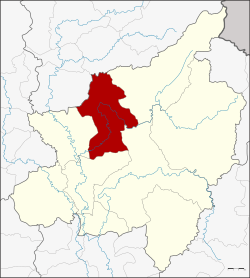
Amphoe Wat Bot
|
Wat Bot วัดโบสถ์ |
|
|---|---|
| Province: | Phitsanulok |
| Surface: | 1,326.21 km² |
| Residents: | 37,573 (2012) |
| Population density : | 28 U / km² |
| ZIP : | 65160 |
| Geocode : | 6507 |
| map | |

|
|
Amphoe Wat Bot ( Thai : อำเภอ วัดโบสถ์ ) is a district ( Amphoe - administrative district) in the north of Phitsanulok Province . The Phitsanulok Province is located in the northern region of Thailand .
geography
topography
Amphoe Wat Bot is located in the north of Phitsanulok province within the basin of the Mae Nam Nan (Nan River) , which flows into the Mae Nam Chao Phraya ( Chao Phraya River ). Wat Bot is also flowed through by the Mae Nam Khwae Noi ( Thai : แม่น้ำ แคว น้อย ) river.
Parts of the Wat Bot area are part of the Khwae Noi Forest Reserve, which was recently incorporated into the Kaeng Chet Khwae National Park .
Neighboring areas
Amphoe Wat Bot is bounded by the following amphoe clockwise from the east: Chat Trakan , Wang Thong , Mueang Phitsanulok and Phrom Phiram in Phitsanulok Province and Phichai and Thong Saen Khan in Uttaradit Province .
history
Wat Bot was formed on January 1, 1948 as a small district ( King Amphoe ) by separating the area from the Amphoe Phrom Phiram . On June 6, 1956, the elevation to a full amphoe took place. The main administration building used today was opened on July 4, 1991.
Attractions
There are 41 active Buddhist temples ( Wat ) in the Amphoe Wat Bot .
administration
Provincial Administration
Amphoe Wat Bot consists of six sub-districts ( tambon ), which are further subdivided into 61 villages ( muban ).
| No. | Surname | Thai | Muban | Pop. |
|---|---|---|---|---|
| 1. | Wat Bot | วัดโบสถ์ | 10 | 8,161 |
| 2. | Tha Ngam | ท่า งาม | 13 | 6,309 |
| 3. | Thothae | ท้อแท้ | 8th | 6,269 |
| 4th | Ban Yang | บ้าน ยาง | 11 | 6,488 |
| 5. | Hin Lat | หิน ลาด | 9 | 4,639 |
| 6th | Khan Chong | คัน โช้ ง | 10 | 5,707 |
Local administration
Wat Bot (Thai: เทศบาล ตำบล วัดโบสถ์ ) is also the name of a small town ( Thesaban Tambon ) in the district. It consists of parts of the Tambon Wat Bot, Tha Ngam and Thothae.
There are also six "Tambon Administrative Organizations" (TAO, องค์การ บริหาร ส่วน ตำบล - administrative organizations) for the tambon in the district that do not belong to any city.
Individual evidence
- ↑ ThinkNet: MapMagic Thailand 2013. Multi-Purposes Bilingual Mapping Software, Bangkok 2013, ThinkNet Co., Ltd., ISBN 978-616-7547-28-2
- ↑ Population statistics 2012 . Department of Provincial Administration. Retrieved June 25, 2014.
Web links
Coordinates: 16 ° 59 ′ N , 100 ° 20 ′ E