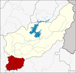
Amphoe Phichai
|
Phichai พิชัย |
|
|---|---|
| Province: | Uttaradit |
| Surface: | 736.7 km² |
| Residents: | 76,975 (2012) |
| Population density : | 105.2 U / km² |
| ZIP : | 53120, 53220 |
| Geocode : | 5307 |
| map | |

|
|
Amphoe Phichai ( Thai : อำเภอ พิชัย , pronunciation: ʔāmpʰɤ̄ː pʰí.tɕʰāj ) is a district ( Amphoe - administrative district) in the province of Uttaradit . The Uttaradit Province is located in the northern region of Thailand . Amphoe Phichai is located in the southwest of the province.
geography
Neighboring districts (clockwise from north): Tron and Thong Saen Khan districts of Uttaradit province, Wat Bot and Phrom Phiram districts of Phitsanulok province, and Sawankhalok and Si Nakhon districts of Sukhothai province .
traffic
In Amphoe Phichai there is the Ban Dara Junction ("Ban Dara Jn.", Ban Dara junction ), where a barely traveled railway line branches off from the northern line of the Thai railway SRT from Bangkok to Chiang Mai to Amphoe Sawankhalok (Sukhothai province) ( see also: State Railway of Thailand ).
administration
Provincial Administration
Amphoe Phichai is divided into eleven communities ( Tambon ) , which in turn are divided into 97 villages ( Muban ) .
| No. | Surname | Thai | Villages | Pop. |
|---|---|---|---|---|
| 1. | Nai Mueang | ใน เมือง | 8th | 9.151 |
| 2. | Ban Dara | บ้าน ดารา | 9 | 6,560 |
| 3. | Rai Oi | ไร่ อ้อย | 11 | 6,786 |
| 4th | Tha Sak | ท่า สัก | 10 | 7,238 |
| 5. | Kho rum | คอ รุม | 12 | 9,527 |
| 6th | Ban Mo | บ้านหม้อ | 8th | 5,894 |
| 7th | Tha Mafueang | ท่า มะเฟือง | 10 | 5,811 |
| 8th. | Ban Khon | บ้าน โคน | 8th | 5,077 |
| 9. | Phaya Maen | พญา แมน | 7th | 6,180 |
| 10. | Well in | นา อิน | 7th | 5,892 |
| 11. | Well Yang | นา ยาง | 7th | 8,859 |
Local administration
There are two small towns ( Thesaban Tambon ) in the county:
- Tha Sak ( เทศบาล ตำบล ท่า สัก ) consists of parts of the Tambon Tha Sak,
- Nai Mueang ( เทศบาล ตำบล ใน เมือง ) consists of parts of the Tambon Nai Mueang.
There are also eleven "Tambon Administrative Organizations" (TAO, องค์การ บริหาร ส่วน ตำบล - administrative organizations) for the tambon in the district that do not belong to any city.
Individual evidence
- ↑ Population statistics 2012 . Department of Provincial Administration. Retrieved June 25, 2014.
Web links
Coordinates: 17 ° 17 ' N , 100 ° 5' E
