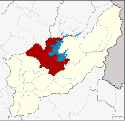
Amphoe Tha Pla
|
Tha Pla ท่าปลา |
|
|---|---|
| Province: | Uttaradit |
| Surface: | 1366 km² |
| Residents: | 44,025 (2014) |
| Population density : | 32.2 U / km² |
| ZIP : | 53150, 53190, 53110 |
| Geocode : | 5303 |
| map | |

|
|
Amphoe Tha Pla ( Thai อำเภอ ท่าปลา , pronunciation: ʔāmpʰɤ̄ː tʰâː plāː ) is a district ( Amphoe - administrative district) in the province of Uttaradit . The Uttaradit Province is located in the northern region of Thailand .
geography
Neighboring counties (clockwise from the east): Amphoe Nam Pat , Thong Saen Khan and Mueang Uttaradit in Uttaradit Province, and Amphoe Den Chai , Sung Men and Mueang Phrae in Phrae Province .
The most important river in the district is the Mae Nam Nan (Nan River) , which with the Queen Sirikit Dam dams a 250 km² artificial lake.
The Maenam Pat (Pat River) flows into the Maenam Nan just after the Queen Sirikit Dam.
economy
Among other things, cashew nuts are produced in the district of Tha Pla . The nuts, dried in the sun and roasted in ovens powered by solar energy , are a five-star OTOP product.
history
Amphoe Tha Pla was originally part of Nan Province . Since 1923 it belongs to the province of Uttaradit.
With effect from February 14, 2015, the Tambon Tha Faek was assigned to the neighboring Amphoe Nam Pat, as it was difficult to reach from the rest of the Amphoe through the Sirikit reservoir.
Attractions
-
National parks :
- Lam Nam Nan National Park (Thai: อุทยานแห่งชาติ ลำน้ำ น่าน ) - the 624,468 Rai (approx. 999 km²) large park is also partly in the Mueang Phrae district. The Queen Sirikit Reservoir is also in the national park.
administration
Provincial Administration
The district of Tha Pla is divided into seven tambon ("sub-districts" or "municipalities"), which are further subdivided into 76 muban ("villages").
| No. | Surname | Thai | Muban | Pop. |
|---|---|---|---|---|
| 1. | Tha Pla | ท่าปลา | 12 | 8,574 |
| 2. | Has La | หาด ล้า | 9 | 4,696 |
| 3. | Pha Lueat | ผา เลือด | 13 | 6,748 |
| 4th | Charim | จริม | 13 | 8,642 |
| 5. | Nam Man | น้ำ หมัน | 12 | 7.172 |
| 7th | Nang Phaya | นางพญา | 6th | 2,634 |
| 8th. | Ruam Chit | ร่วม จิต | 11 | 5,559 |
Number 6 belonged to the tambon Tha Faek that is now part of the Nam Pat district.
Local administration
There are three municipalities with "small town" status ( Thesaban Tambon ) in the district:
- Tha Pla (Thai: เทศบาล ตำบล ท่าปลา ) consisting of parts of the Tambon Tha Pla.
- Ruam Chit (Thai: เทศบาล ตำบล ร่วม จิต ) consisting of parts of the Tambon Ruam Chit.
- Charim (Thai: เทศบาล ตำบล จริม ) consisting of the complete tambon Charim.
In addition, there are six " tambon administration organizations " ( องค์การ บริหาร ส่วน ตำบล - Tambon Administrative Organizations, TAO)
- Tha Pla (Thai: องค์การ บริหาร ส่วน ตำบล ท่าปลา ) consisting of parts of the Tambon Tha Pla.
- Hat La (Thai: องค์การ บริหาร ส่วน ตำบล หาด ล้า ) consisting of the complete Tambon Hat La.
- Pha Lueat (Thai: องค์การ บริหาร ส่วน ตำบล ผา เลือด ) consisting of the complete tambon Pha Lueat.
- Nam Man (Thai: องค์การ บริหาร ส่วน ตำบล น้ำ หมัน ) consisting of the complete Tambon Nam Man.
- Nang Phaya (Thai: องค์การ บริหาร ส่วน ตำบล นางพญา ) consisting of the complete Tambon Nang Phaya.
- Ruam Chit (Thai: องค์การ บริหาร ส่วน ตำบล ร่วม จิต ) consisting of parts of the Tambon Ruam Chit.
Individual evidence
- ↑ Page about 5-star OTOP products from Amphoe Tha Pla (in English)
- ↑ ประกาศ โอน อำเภอ ท่าปลา จาก จังหวัด น่าน มา ขึ้น จังหวัด อุตรดิตถ์ . In: Royal Gazette . 39, No. 0 ก, June 4, 1922, p. 55.
- ↑ พระราชกฤษฎีกา เปลี่ยน เขต อำเภอ ท่าปลา กับ อำเภอ น้ำปาด จังหวัด อุตรดิตถ์ พ.ศ. ๒๕๕๘ . In: Royal Gazette . 132, No. 10 ก, February 13, 2015, pp. 62–64.
- ↑ 2014 population statistics ( Thai ) Department of Provincial Administration. Retrieved February 20, 2015.
Web links
- More details about Amphoe Tha Pla from amphoe.com (in Thai)
- Description of the Lam Nam Nan National Park (in English)
Coordinates: 17 ° 48 ' N , 100 ° 23' E

