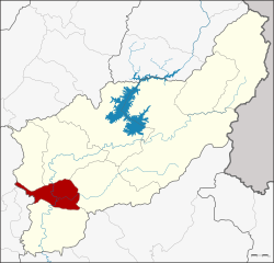
Amphoe Tron
|
Tron ตรอน |
|
|---|---|
| Province: | Uttaradit |
| Surface: | 314.5 km² |
| Residents: | 34,832 (2012) |
| Population density : | 113.6 U / km² |
| ZIP : | 53140 |
| Geocode : | 5302 |
| map | |

|
|
Amphoe Tron ( Thai อำเภอ ตรอน , pronunciation: ʔāmpʰɤ̄ː trɔ̄ːn ) is a district ( Amphoe - administrative district) in the west of the Uttaradit province . The Uttaradit Province is located in the northern region of Thailand .
geography
Neighboring counties (clockwise from north): the Amphoe Laplae , Mueang Uttaradit , Thong Saen Khan and Phichai of Uttaradit Province and Si Nakhon and Si Satchanalai of Sukhothai Province .
administration
Provincial Administration
The district is divided into five communes ( tambon ) , which are further divided into 47 villages ( muban ) .
| No. | Surname | Thai | Muban | Pop. |
|---|---|---|---|---|
| 1. | Wang Daeng | วัง แดง | 12 | 11,031 |
| 2. | Ban Kaeng | บ้าน แก่ง | 10 | 7,426 |
| 3. | Has Song Khwae | หาด สอง แคว | 7th | 4.211 |
| 4th | Nam Ang | น้ำ อ่าง | 10 | 7,872 |
| 5. | Khoi Sung | ข่อย สูง | 8th | 4,292 |
Local administration
There are two small towns ( Thesaban Tambon ) in the district:
- Tron ( เทศบาล ตำบล ตรอน ) consists of parts of the Tambon Wang Daeng,
- Ban Kaeng ( เทศบาล ตำบล บ้าน แก่ง ) consists of parts of the Tambon Ban Kaeng.
There are also five “Tambon Administrative Organizations” (TAO, องค์การ บริหาร ส่วน ตำบล - Administrative Organizations) for the tambon in the district that do not belong to any city.
Individual evidence
- ↑ Population statistics 2012 . Department of Provincial Administration. Retrieved June 25, 2014.
Web links
Coordinates: 17 ° 29 ' N , 100 ° 7' E
