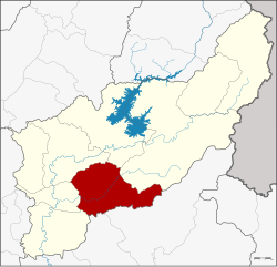
Amphoe Thong Saen Khan
|
Thong Saen Khan ทอง แสน ขัน |
|
|---|---|
| Province: | Uttaradit |
| Surface: | 745.4 km² |
| Residents: | 32,571 (2012) |
| Population density : | 44.3 U / km² |
| ZIP : | 53230 |
| Geocode : | 5309 |
| map | |

|
|
Amphoe Thong Saen Khan ( Thai อำเภอ ทอง แสน ขัน , pronunciation: ʔāmpʰɤ̄ː tʰɔ̄ːŋ sɛ̌ːn kʰǎn ) is a district ( Amphoe ) in the south of the Uttaradit province . The Uttaradit Province is located in the northern region of Thailand .
geography
Neighboring counties (from southwest clockwise): the Amphoe Phichai , Tron, Mueang Uttaradit , Tha Pla , Nam Pat of the province of Uttaradit, as well as Chat Trakan and Wat Bot of the province of Phitsanulok .
history
Ban Hong was founded on July 1, 1983 as a subdistrict ( King Amphoe ), consisting of four tambon that were split off from Tron County . On May 21, 1990, the subdistrict was given full amphoe status.
Attractions
administration
Provincial Administration
The district is divided into four communes ( tambon ) , which are further subdivided into 49 villages ( muban ) .
| No. | Surname | Thai | Muban | Pop. |
|---|---|---|---|---|
| 1. | Phak Khuang | ผักขวง | 16 | 8,947 |
| 2. | Bo thong | บ่อ ทอง | 15th | 12,296 |
| 3. | Pa Khai | ป่า คาย | 9 | 5,759 |
| 4th | Nam Phi | น้ำ พี้ | 9 | 5,569 |
Local administration
Thong Saen Khan ( เทศบาล ตำบล ทอง แสน ขัน ) is a small town ( Thesaban Tambon ) in the district. It consists of parts of the Tambon Bo Thong.
There are also four “Tambon Administrative Organizations” (TAO, องค์การ บริหาร ส่วน ตำบล - administrative organizations) for the tambon in the district that do not belong to any city.
Individual evidence
- ↑ ประกาศ กระทรวง มหาดไทย เรื่อง แบ่ง ท้องที่ อำเภอ ตรอน จังหวัด อุตรดิตถ์ ตั้ง เป็น กิ่ง อำเภอ ทอง แสน ขัน . In: Royal Gazette . 100, No. 109 ง, July 5, 1983, p. 2134.
- ↑ พระราชกฤษฎีกา ตั้ง อำเภอ ห้วย ผึ้ง อำเภอ วัง วิเศษ อำเภอ คลอง หาด อำเภอ ป่า บอน อำเภอ หนองหญ้าปล้อง อำเภอ วัง โป่ง อำเภอ ควน เนียง อำเภอ หนอง หนอง หญ้า ไซ อำเภอ บ้านนาเดิม อำเภอ ทุ่งฝน อำเภอ สร้างคอม และ อำเภอ ทอง แสน ขัน พ.ศ. ๒๕๓๓ . In: Royal Gazette . 107, No. 83 ก special, May 21, 1990, pp. 1-4.
- ↑ Population statistics 2012 . Department of Provincial Administration. Retrieved June 25, 2014.
Web links
Coordinates: 17 ° 29 ′ N , 100 ° 20 ′ E
