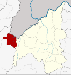
Amphoe Na Haeo
|
Well Haeo นาแห้ว |
|
|---|---|
| Province: | Loei |
| Surface: | 262.0 km² |
| Residents: | 11,398 (2013) |
| Population density : | 17.5 U / km² |
| ZIP : | 42170 |
| Geocode : | 4206 |
| map | |

|
|
Amphoe Na Haeo ( Thai : อำเภอ นาแห้ว , pronunciation: ʔāmpʰɤ̄ː nāː hɛ̂w ) is a district ( Amphoe - administrative district) in the west of Loei Province . The province of Loei is located in the western part of the northeast region of Thailand , the so-called Isan .
geography
Adjacent counties and areas are (from east clockwise): Amphoe Dan Sai in Loei province, as well as the Amphoe Nakhon Thai and Chat Trakan the province of Phitsanulok . To the north lies the Sayaburi province of Laos .
The most important river in the district is the Lamnam Hueang (Thai: ลำน้ำ เหื อง - Hueang River ), which forms the border to Laos for 90 kilometers of its total length of 110 kilometers.
The National Park Phu Suan Sai is located in this district.
history
Na Haeo was initially set up on February 15, 1970 as a "branch circle" ( King Amphoe ) by separating the two Tambon Na Haeo and Na Phueng from the Amphoe Dan Sai. On September 8, 1976, it was promoted to Amphoe .
administration
Provincial Administration
The Na Haeo district is divided into five tambon ("subdistricts" or "municipalities"), which are further subdivided into 34 muban ("villages").
| No. | Surname | Thai | Muban | Pop. |
|---|---|---|---|---|
| 1. | Well, Haeo | นาแห้ว | 7th | 2,024 |
| 2. | Saeng Pha | แสง ภา | 6th | 1,828 |
| 3. | Well Phueng | นา พึง | 8th | 2,097 |
| 4th | Well Ma La | นา มาลา | 8th | 3.114 |
| 5. | Lao Ko Hok | เหล่ากอ หก | 5 | 2,335 |
Local administration
There is one municipality with "small town" status ( Thesaban Tambon ) in the district:
- Na Haeo (Thai: เทศบาล ตำบล นาแห้ว ) consisting of the complete tambon Na Haeo.
There are also four " Tambon Administrative Organizations " ( องค์การ บริหาร ส่วน ตำบล - Tambon Administrative Organizations, TAO):
- Saeng Pha (Thai: องค์การ บริหาร ส่วน ตำบล แสง ภา ) consisting of the complete tambon Saeng Pha.
- Na Phueng (Thai: องค์การ บริหาร ส่วน ตำบล นา พึง ) consisting of the complete tambon Na Phueng.
- Na Ma La (Thai: องค์การ บริหาร ส่วน ตำบล นา มาลา ) consisting of the complete tambon Na Ma La.
- Lao Ko Hok (Thai: องค์การ บริหาร ส่วน ตำบล เหล่ากอ หก ) consisting of the complete tambon Lao Ko Hok.
Individual evidence
- ↑ ประกาศ กระทรวง มหาดไทย เรื่อง แบ่ง ท้องที่ ตั้ง เป็น กิ่ง อำเภอ . In: Royal Gazette . 87, No. 17 ง , March 3, 1970, p. 854.
- ↑ พระราชกฤษฎีกา ตั้ง อำเภอ เลาขวัญ อำเภอ คำม่วง อำเภอ พิปูน อำเภอ ศรีเทพ อำเภอ นาแห้ว อำเภอ ส่องดาว อำเภอ ควนกาหลง อำเภอ ค่ายบางระจัน อำเภอ บ้านตาขุน และ อำเภอ กุดจับ พ.ศ. ๒๕๑๙ . In: Royal Gazette . 93, No. 109 ก ฉบับ พิเศษ (special), September 8, 1976, pp. 31-34.
- ↑ 2013 population statistics ( Thai ) Department of Provincial Administration. Retrieved July 29, 2014.
Web links
- More details on Amphoe Na Haeo from amphoe.com (in Thai)
- Information on Phu Suan Sai National Park (in English)
Coordinates: 17 ° 29 ' N , 101 ° 4' E
