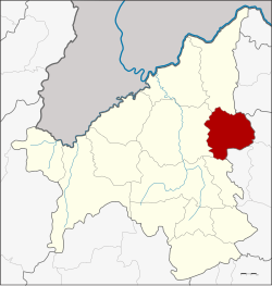
Na Duang district
|
Well Duang นาด้วง |
|
|---|---|
| Province: | Loei |
| Surface: | 590.0 km² |
| Residents: | 26,087 (2013) |
| Population density : | 42.8 U / km² |
| ZIP : | 42210 |
| Geocode : | 4202 |
| map | |

|
|
Amphoe Na Duang ( Thai : อำเภอ นาด้วง }, pronunciation: ʔāmpʰɤ̄ː nāː dûaŋ ) is a district ( Amphoe - administrative district) in the east of the province of Loei . The province of Loei is located in the northwestern part of the northeast region of Thailand , the so-called Isan .
geography
Adjacent counties and areas are (from south clockwise): Amphoe Erawan , Mueang Loei and Pak Chom in the province of Loei, Amphoe Nam Som of Udon Thani province and Amphoe Suwannakhuha , Na sound and Na Wang of the province of Nong Bua Lamphu .
history
The area of today's Na Duang County was originally called Ban Na Duang, it was a village named after the hunter Duang and was subordinate to Udon Thani Province . Duang brought his people here in 1881 and founded a new village community.
In 1945 the village was assigned to the Tambon Thung Pho of Mueang Loei County , later in 1967 to the Tambon Na Din Dam. In 1976 Na Duang got tambon status itself . On January 17, 1977 it was upgraded to a "branch circle" ( King Amphoe ) together with three other tambon . On July 19, 1991, Na Duang was granted full amphoe status.
administration
Provincial Administration
Na Duang County is divided into four tambon ("subdistricts" or "municipalities"), which are further subdivided into 41 muban ("villages").
| No. | Surname | Thai | Muban | Pop. |
|---|---|---|---|---|
| 1. | Well Duang | นาด้วง | 12 | 9,530 |
| 2. | Well, Dok Kham | นา ดอก คำ | 17th | 9,861 |
| 3. | Tha Sa-at | ท่า สะอาด | 7th | 3,756 |
| 4th | Tha Sawan | ท่า สวรรค์ | 5 | 2,940 |
Local administration
There are two municipalities with "small town" status ( Thesaban Tambon ) in the district:
- Na Duang (Thai: เทศบาล ตำบล นาด้วง ) consisting of parts of the Tambon Na Duang.
- Na Dok Kham (Thai: เทศบาล ตำบล นา ดอก คำ ) consisting of the complete tambon Na Dok Kham.
There are also three " Tambon Administrative Organizations " ( องค์การ บริหาร ส่วน ตำบล - Tambon Administrative Organizations, TAO):
- Na Duang (Thai: องค์การ บริหาร ส่วน ตำบล นาด้วง ) consisting of parts of the Tambon Na Duang.
- Tha Sa-at (Thai: องค์การ บริหาร ส่วน ตำบล ท่า สะอาด ) consisting of the complete tambon Tha Sa-at.
- Tha Sawan (Thai: องค์การ บริหาร ส่วน ตำบล ท่า สวรรค์ ) consisting of the complete tambon Tha Sawan.
Individual evidence
- ↑ ประกาศ กระทรวง มหาดไทย เรื่อง แบ่ง ท้องที่ อำเภอ เมือง เลย จังหวัด เลย ตั้ง เป็น กิ่ง อำเภอ นาด้วง Royal Gazette, Volume 94, Issue 10 ง of February 1, 1977, p. 366 (in Thai)
- ↑ พระราชกฤษฎีกา ตั้ง อำเภอ ทุ่งตะโก อำเภอ พะโต๊ะ อำเภอ เขา ค้อ อำเภอ น้ำ หนาว อำเภอ วัง จันทร์ อำเภอ นาด้วง อำเภอ เต่า ง อย อำเภอ สิงห สิงห นคร อำเภอ พระ สมุทร เจดีย์ และ อำเภอ ลำดวน พ.ศ. ๒๕๓๔ Royal Gazette, Volume 108, Ed. 107 ก special ( ฉบับ พิเศษ ) from June 19, 1991 pp. 29–33 (in Thai)
- ↑ 2013 population statistics ( Thai ) Department of Provincial Administration. Retrieved July 29, 2014.
Web links
Coordinates: 17 ° 29 ′ N , 101 ° 58 ′ E
