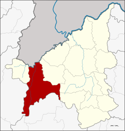
Dan Sai district
|
Dan Sai ด่านซ้าย |
|
|---|---|
| Province: | Loei |
| Surface: | 1732.0 km² |
| Residents: | 51,086 (2012) |
| Population density : | 28.4 U / km² |
| ZIP : | 42120 |
| Geocode : | 4205 |
| map | |

|
|
Amphoe Dan Sai ( Thai : อำเภอ ด่านซ้าย , pronunciation: ʔāmpʰɤ̄ː dàːn sáːj ) is a district ( Amphoe - administrative district) in the west of Loei Province . The province of Loei is located in the northwestern part of the northeast region of Thailand , the so-called Isan .
geography
Neighboring counties and areas are (clockwise from the east): Amphoe Phu Ruea in the province of Loei, Lom Kao and Khao Kho in the province of Phetchabun , Nakhon Thai in the province of Phitsanulok and Amphoe Na Haeo in Loei. To the north lies the Sayaburi Province of the People's Democratic Republic of Laos .
The source of Maenam Pa Sak ( แม่น้ำ ป่า สัก - Pa-Sak River ) is located in the mountains in the eastern part of the district. A large part of the district is in the Phu Hin Rong Kla National Park . To the southeast lies the Phu Luang Game Reserve (Phu Luang Wildlife Sanctuary) .
The district capital Dan Sai is located in the upper end of a basin of the Man River, which flows into the Nam Heang at Pak Man, a tributary of the Mekong .
Attractions
- Phra That Si Song Rak (Thai: วัด พระ ธาตุ ศรี สอง รัก , for example: Chedi of the love of two nations , also “Phra That Sri Song Hak”) - Chedi in the Laotian style, built in 1516 jointly by Thai and Laotian kings.
administration
Provincial Administration
Dan Sai County is divided into ten tambon ("subdistricts" or "parishes"), which are further subdivided into 99 muban ("villages").
| No. | Surname | Thai | Muban | Pop. |
|---|---|---|---|---|
| 1. | Dan Sai | ด่านซ้าย | 15th | 9,449 |
| 2. | Pak Man | ปาก หมัน | 7th | 2,977 |
| 3. | Well Tuesday | นาดี | 9 | 3.813 |
| 4th | Khok Ngam | โคก งาม | 7th | 4,778 |
| 5. | Phon Sung | โพน สูง | 9 | 4,930 |
| 6th | Ipum | อิ ปุ่ม | 13 | 4,670 |
| 7th | Kok Sathon | กก สะ ทอน | 12 | 7,738 |
| 8th. | Pong | โป่ง | 11 | 6,063 |
| 9. | Wang Yao | วัง ยาว | 7th | 3,645 |
| 10. | Well ho | นา หอ | 9 | 3,023 |
Local administration
There are two municipalities with "small town" status ( Thesaban Tambon ) in the district:
- Si Song Rak (Thai: เทศบาล ตำบล ศรี สอง รัก ) consisting of parts of the Tambon Dan Sai.
- Dan Sai (Thai: เทศบาล ตำบล ด่านซ้าย ) consisting of parts of the Tambon Dan Sai.
There are also nine " Tambon Administrative Organizations " ( องค์การ บริหาร ส่วน ตำบล - Tambon Administrative Organizations, TAO):
- Pak Man (Thai: องค์การ บริหาร ส่วน ตำบล ปาก หมัน ) consisting of the complete Tambon Pak Man.
- Na Di (Thai: องค์การ บริหาร ส่วน ตำบล นาดี ) consisting of the complete tambon Na Di.
- Khok Ngam (Thai: องค์การ บริหาร ส่วน ตำบล โคก งาม ) consisting of the complete tambon Khok Ngam.
- Phon Sung (Thai: องค์การ บริหาร ส่วน ตำบล โพน สูง ) consisting of the complete tambon Phon Sung.
- Ipum (Thai: องค์การ บริหาร ส่วน ตำบล อิ ปุ่ม ) consisting of the complete tambon Ipum.
- Kok Sathon (Thai: องค์การ บริหาร ส่วน ตำบล กก สะ ทอน ) consisting of the complete Tambon Kok Sathon.
- Pong (Thai: องค์การ บริหาร ส่วน ตำบล โป่ง ) consisting of the complete Tambon Pong.
- Wang Yao (Thai: องค์การ บริหาร ส่วน ตำบล วัง ยาว ) consisting of the complete tambon Wang Yao.
- Na Ho (Thai: องค์การ บริหาร ส่วน ตำบล นา หอ ) consisting of the complete tambon Na Ho.
Individual evidence
- ↑ 2013 population statistics ( Thai ) Department of Provincial Administration. Retrieved July 29, 2014.
Web links
Coordinates: 17 ° 17 ' N , 101 ° 9' E


