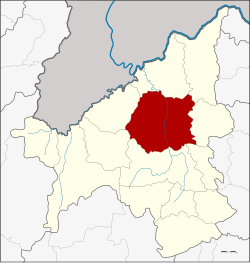
Amphoe Mueang Loei
|
Mueang Loei เมือง เลย |
|
|---|---|
| Province: | Loei |
| Surface: | 1480.49 km² |
| Residents: | 122,916 (2013) |
| Population density : | 79.1 U / km² |
| ZIP : | 42000, 42100 |
| Geocode : | 4201 |
| map | |

|
|
Amphoe Mueang Loei ( Thai : อำเภอ เมือง เลย }, pronunciation: ʔāmpʰɤ̄ː mɯ̄aŋ lɤ̄ːj ) is a district ( amphoe - administrative district) in the province of Loei . The province of Loei is located in the northwestern part of the northeast region of Thailand , the so-called Isan .
geography
Neighboring districts (clockwise from north): the Amphoe Chiang Khan , Pak Chom , Na Duang , Erawan , Wang Saphung , Phu Ruea and Tha Li . All counties are in the province of Loei.
Economy and Importance
Loei is a modest economic center on the border with Laos.
In addition to agriculture ( cotton ), copper ore , manganese ore and other ores are mined.
Airport
history
In 1853, under King Mongkut (Rama IV.), The first attempts at a controlled development of the area were made and Loei was made a city. Today's Mueang Loei was one of the five original districts that formed the new Loei Province through the Thesaphiban administrative reform in 1897. The original name was Kut Pong, after the central tambon . It was only later that the area was given the current name of Mueang Loei.
education
The Rajabhat University of Loei is located in the Amphoe Mueang Loei .
administration
Provincial Administration
The district of Mueang Loei is divided into 14 tambon ("subdistricts" or "municipalities"), which are further subdivided into 135 muban ("villages").
| No. | Surname | Thai | Muban | Pop. |
|---|---|---|---|---|
| 1. | Kut Pong | กุด ป่อง | - | 22,020 |
| 2. | Mueang | เมือง | 13 | 12,298 |
| 3. | Well O | นา อ้อ | 9 | 6,190 |
| 4th | Kok you | กก ดู่ | 10 | 7.109 |
| 5. | Nam Man | น้ำ หมา น | 6th | 3,912 |
| 6th | Siao | เสี้ยว | 6th | 3,665 |
| 7th | Well an | นา อาน | 12 | 11,985 |
| 8th. | Well pong | นา โป่ง | 16 | 9,937 |
| 9. | Well Din Dam | นา ดินดำ | 14th | 10,610 |
| 10. | Nam Suai | น้ำ สวย | 13 | 10,979 |
| 11. | Chaiyaphruek | ชัยพฤกษ์ | 11 | 6,622 |
| 12. | Well, Khaem | นา แขม | 9 | 6,797 |
| 13. | Si Song Rak | ศรี สอง รัก | 11 | 8,090 |
| 14th | Kok Thong | กก ทอง | 5 | 2,702 |
Local administration
There is one commune with "city" status ( Thesaban Mueang ) in the district:
- Loei (Thai: เทศบาล เมือง เลย ) consisting of the complete Tambon Kut Pong.
There are five municipalities with "small town" status ( Thesaban Tambon ) in the district:
- Na O (Thai: เทศบาล ตำบล นา อ้อ ) consisting of the complete tambon Na O.
- Nam Suai (Thai: เทศบาล ตำบล น้ำ สวย ) consisting of parts of the Tambon Nam Suai.
- Na An (Thai: เทศบาล ตำบล นา อาน ) consisting of the complete tambon Na An.
- Na Pong (Thai: เทศบาล ตำบล นา โป่ง ) consisting of the complete Tambon Na Pong.
- Na Din Dam (Thai: เทศบาล ตำบล นา ดินดำ ) consisting of the complete tambon Na Din Dam.
There are also nine " Tambon Administrative Organizations " ( องค์การ บริหาร ส่วน ตำบล - Tambon Administrative Organizations, TAO):
- Mueang (Thai: องค์การ บริหาร ส่วน ตำบล เมือง ) consisting of the complete Tambon Mueang.
- Kok Du (Thai: องค์การ บริหาร ส่วน ตำบล กก ดู่ ) consisting of the complete Tambon Kok Du.
- Nam Man (Thai: องค์การ บริหาร ส่วน ตำบล น้ำ หมา น ) consisting of the complete Tambon Nam Man.
- Siao (Thai: องค์การ บริหาร ส่วน ตำบล เสี้ยว ) consisting of the complete Tambon Siao.
- Nam Suai (Thai: องค์การ บริหาร ส่วน ตำบล น้ำ สวย ) consisting of parts of the Tambon Nam Suai.
- Chaiyaphruek (Thai: องค์การ บริหาร ส่วน ตำบล ชัยพฤกษ์ ) consisting of the complete tambon Chaiyaphruek.
- Na Khaem (Thai: องค์การ บริหาร ส่วน ตำบล นา แขม ) consisting of the complete Tambon Na Khaem.
- Si Song Rak (Thai: องค์การ บริหาร ส่วน ตำบล ศรี สอง รัก ) consisting of the complete tambon Si Song Rak.
- Kok Thong (Thai: องค์การ บริหาร ส่วน ตำบล กก ทอง ) consisting of the complete Tambon Kok Thong.
Individual evidence
- ↑ 2013 population statistics ( Thai ) Department of Provincial Administration. Retrieved July 29, 2014.
Web links
Coordinates: 17 ° 29 ' N , 101 ° 44' E
