Pha Khao district
|
Pha Khao ผา ขาว |
|
|---|---|
| Province: | Loei |
| Surface: | 463.0 km² |
| Residents: | 41,530 (2013) |
| Population density : | 86.5 U / km² |
| ZIP : | 42240 |
| Geocode : | 4212 |
| map | |

|
|
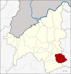
Amphoe Pha Khao ( Thai : อำเภอ ผา ขาว , pronunciation: ʔāmpʰɤ̄ː pʰǎː kʰǎːw , literally: District of the White Cliff ) is a district ( Amphoe - administrative district) in the east of Loei Province . The province of Loei is located in the western part of the northeast region of Thailand , the so-called Isan .
geography
Adjacent counties and areas are (from south clockwise): Amphoe Phu Kradueng , Nong Hin , Wang Saphung and Erawan in the province of Loei and Amphoe Si Bun Rueang the province of Nong Bua Lamphu Province .
history
Pha Khao was initially set up as a "branch circle" ( King Amphoe ) on January 1, 1988 , by separating the four tambon Pha Khao, Tha Chang Khlong, Non Po Daeng and Non Pa Sang from the Phu Kradueng Amphoe . On November 3, 1993, it was promoted to Amphoe.
administration
Provincial Administration
Pha Khao County is divided into 5 tambon ("subdistricts" or "communities"), which are further subdivided into 64 muban ("villages").
| No. | Surname | Thai | Muban | Pop. |
|---|---|---|---|---|
| 1. | Pha Khao | ผา ขาว | 12 | 6,642 |
| 2. | Tha Chang Khlong | ท่าช้าง คล้อง | 14th | 10,821 |
| 3. | Non Po Daeng | โนน ปอ แดง | 17th | 10,834 |
| 4th | Non Pa Sang | โนน ป่าซาง | 12 | 7,620 |
| 5. | Ban phoem | บ้าน เพิ่ม | 9 | 5,613 |
Local administration
There are two municipalities with "small town" status ( Thesaban Tambon ) in the district:
- Tha Chang Khlong (Thai: เทศบาล ตำบล ท่าช้าง คล้อง ) consisting of the complete tambon Tha Chang Khlong.
- Non Po Daeng (Thai: เทศบาล ตำบล โนน ปอ แดง ) consisting of the complete tambon Non Po Daeng.
There are also three " Tambon Administrative Organizations " ( องค์การ บริหาร ส่วน ตำบล - Tambon Administrative Organizations, TAO):
- Pha Khao (Thai: องค์การ บริหาร ส่วน ตำบล ผา ขาว ) consisting of the complete tambon Pha Khao.
- Non Pa Sang (Thai: องค์การ บริหาร ส่วน ตำบล โนน ป่าซาง ) consisting of the complete tambon Non Pa Sang.
- Ban Phoem (Thai: องค์การ บริหารส่วน ตำบล บ้าน เพิ่ม ) consisting of the complete tambon Ban Phoem.
Individual evidence
- ↑ ประกาศ กระทรวง มหาดไทย เรื่อง แบ่ง เขต ท้องที่ อำเภอ ภูกระดึง จังหวัด เลย ตั้ง เป็น กิ่ง อำเภอ ผา ขาว . In: Royal Gazette . 105, No. 5 ง , January 7, 1988, p. 109.
- ↑ พระราชกฤษฎีกา ตั้ง อำเภอ ลำ ทับ อำเภอ ร่องคำ อำเภอ เวียง แหง อำเภอ นา โยง อำเภอ แก้ง สนาม นาง อำเภอ โนน แดง อำเภอ บ้านหลวง อำเภอ กะพ้อ อำเภอ ศรี บรรพต บรรพต อำเภอ แก่ง กระจาน อำเภอ อำเภอ หนอง สูง อำเภอ สบ เมย อำเภอ เมย วดี อำเภอ โคก เจริญ อำเภอ ทุ่งหัวช้าง อำเภอ วัง ขาว ขาว ขาว ขาว ขาว ขาว หิน อำเภอ ดอนพุด อำเภอ บึง โขง หลง และ อำเภอ ห้วย ค ต พ.ศ. ๒๕๓๖ . In: Royal Gazette . 110, No. 179 ก special ( ฉบับ พิเศษ ), November 3, 1993, pp. 1-3.
- ↑ 2013 population statistics ( Thai ) Department of Provincial Administration. Retrieved July 29, 2014.
Web links
Coordinates: 17 ° 4 ' N , 102 ° 2' E
