
Lom Sak district
|
Lom Sak หล่มสัก |
|
|---|---|
| Province: | Phetchabun |
| Surface: | 1,535.3 km² |
| Residents: | 157,576 (2013) |
| Population density : | 98.1 U / km² |
| ZIP : | 67110 |
| Geocode : | 6703 |
| map | |

|
|
Amphoe Lom Sak ( Thai อำเภอ หล่มสัก , also Lomsak ) is a district ( Amphoe - administrative district) in Phetchabun Province . Phetchabun Province is located in the extreme southeast of the northern region of Thailand .
geography
Neighboring districts are (clockwise from north): the Amphoe Lom Kao and Nam Nao of Phetchabun province , Khon San District ( Chaiyaphum province ) and the Amphoe Mueang Phetchabun and Khao Kho (Phetchabun province).
Lom Sak is the starting point for a visit to the Phu Hin Rong Kla National Park ( Phitsanulok Province ), which is famous for its wilderness and the flora that is unique in Thailand, including maple and pine forests. This is because this area has the lowest average temperatures in Thailand, in the winter months (November to February) even down to freezing point. The mountains are consistently steep and have a height of up to 1,800 meters. There are very interesting rock formations in the park, including a "Flag Post Cliff" (Thai: ผา ชู ธง - Pha Chuthong ) called vantage point, which was used by guerrilla troops as a flagpole that could be seen from afar.

Street scene in Lom Sak

Market hall
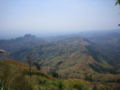
View over the Phu Hin Rong Kla National Park


history
The history of the Lom Sak district can be traced back to the Sukhothai period. The governor of the Müang Council (possibly today's Lom Sak) Pho Khun Pha Mueang ( พ่อขุน ผา เมือง ) was one of the warlords who drove the Khmer out of Siam . Then he founded the kingdom of Sukhothai together with his friend Pho Khun Bang Klang Hao ( พ่อขุน บาง กลางหาว ) and encouraged his friend to rule the kingdom as the first king Pho Khun Si Indrathit .
Another reference to Lom Sak can be found on the famous "Inscription I" by King Ramkhamhaeng , the original of which can now be seen in the Bangkok National Museum . There the king describes that his sphere of influence extends in the east to Phitsanulok and Lom Sak, to the south to Nakhon Sawan , to the west to Pegu and Martaban and to the north to Phrae and Luang Prabang .
During the reign of King Taksin , Phraya Chakri (later King Rama I ) camped in the area of what is now Amphoe Lom Kao on his return from his campaign in Vientiane . Here he settled some prisoners of war from Vientiane. As the settlement grew, it was moved to the plain on the Mae Nam Pa Sak (Pa-Sak River) and called Lom Sak . Later, other Lao from Vientiane, which King Taksin originally intended to settle in Lopburi, joined the city.
According to the historian Prince Damrong Rajanubhab , Mueang Lom Sak is said to have been officially founded during the reign of King Phra Nang Klao ( Rama III ). When King Chulalongkorn (Rama V) created the Monthon as part of his Thesaphiban administrative reform , Mueang Lom Sak was administered by the Monthon Petchabun. It was later downgraded to a district of Petchabun Province. In 1916 the district was called Wat Pa ( วัด ป่า ), but on November 11, 1938 it was changed back to Lom Sak.
Communist groups tried to gain a foothold in the area during the Vietnam War . They set up a headquarters and several training camps in the rough terrain. They fought successfully against government troops for several years from 1973 onwards, but were finally expelled in 1979. In various places in the park, partly restored buildings testify to the history of the guerrillas . The animal world suffered greatly during the fighting, so that today, among other things, Asian black bears, tigers, leopards and various types of owls can be found.
administration
Provincial Administration
Lom Sak County is divided into 23 tambon ("subdistricts" or "parishes"), which are further subdivided into 251 muban ("villages").
| No. | Surname | Thai | Muban | Pop. |
|---|---|---|---|---|
| 1. | Lom Sak | หล่มสัก | - | 12,461 |
| 2. | Wat Pa | วัด ป่า | 12 | 8,584 |
| 3. | Tan Diao | ตาล เดี่ยว | 11 | 5,749 |
| 4th | Fai Na Saeng | ฝาย นา แซง | 6th | 2,672 |
| 5. | Nong Sawang | หนอง สว่าง | 4th | 1,291 |
| 6th | Nam Hia | น้ำ เฮี้ ย | 5 | 1,719 |
| 7th | Sak Long | สัก หลง | 11 | 5,827 |
| 8th. | Tha Ibun | ท่า อิ บุญ | 12 | 7.162 |
| 9. | Ban Sok | บ้าน โสก | 7th | 4,262 |
| 10. | Ban Tio | บ้าน ติ้ว | 12 | 8,276 |
| 11. | Huai Rai | ห้วย ไร่ | 13 | 7,712 |
| 12. | Nam Ko | น้ำ ก้อ | 13 | 6,687 |
| 13. | Pak Chong | ปากช่อง | 17th | 13,271 |
| 14th | Nam Chun | น้ำ ชุน | 17th | 15.091 |
| 15th | Nong Khwai | หนอง ไขว่ | 15th | 7,600 |
| 16. | Lan Ba | ลาน บ่า | 18th | 7,504 |
| 17th | Bung Khla | บุ่ง คล้า | 14th | 8,045 |
| 18th | Bung Namtao | บุ่ง น้ำเต้า | 12 | 6,389 |
| 19th | Ban sound | บ้าน กลาง | 19th | 9,724 |
| 20th | Chang Talut | ช้าง ตะ ลู ด | 13 | 7,030 |
| 21st | Ban Rai | บ้านไร่ | 6th | 2,531 |
| 22nd | Pak Duk | ปาก ดุก | 7th | 3,494 |
| 23. | Ban Wai | บ้าน หวาย | 7th | 4,495 |
Local administration
There is one commune with "city" status ( Thesaban Mueang ) in the district:
- Lom Sak (Thai: เทศบาล เมือง หล่มสัก ) consisting of the complete Tambon Lom Sak.
There is one municipality with "small town" status ( Thesaban Tambon ) in the district:
- Tan Diao (Thai: เทศบาล ตำบล ตาล เดี่ยว ) consisting of the complete tambon Tan Diao.
There are also 19 " tambon administration organizations " ( องค์การ บริหาร ส่วน ตำบล - Tambon Administrative Organizations, TAO)
- Wat Pa (Thai: องค์การ บริหาร ส่วน ตำบล วัด ป่า ) consisting of the complete Tambon Wat Pa.
- Fai Na Saeng (Thai: องค์การ บริหาร ส่วน ตำบล ฝาย นา แซง ) consisting of the complete tambon Fai Na Saeng, Nong Sawang, Nam Hia.
- Sak Long (Thai: องค์การ บริหาร ส่วน ตำบล สัก หลง ) consisting of the complete tambon Sak Long.
- Tha Ibun (Thai: องค์การ บริหาร ส่วน ตำบล ท่า อิ บุญ ) consisting of the complete tambon Tha Ibun.
- Ban Sok (Thai: องค์การ บริหาร ส่วน ตำบล บ้าน โสก ) consisting of the complete tambon Ban Sok.
- Ban Tio (Thai: องค์การ บริหาร ส่วน ตำบล บ้าน ติ้ว ) consisting of the complete tambon Ban Tio.
- Huai Rai (Thai: องค์การ บริหาร ส่วน ตำบล ห้วย ไร่ ) consisting of the complete tambon Huai Rai.
- Nam Ko (Thai: องค์การ บริหาร ส่วน ตำบล น้ำ ก้อ ) consisting of the complete tambon Nam Ko.
- Pak Chong (Thai: องค์การ บริหาร ส่วน ตำบล ปากช่อง ) consisting of the complete Tambon Pak Chong.
- Nam Chun (Thai: องค์การ บริหาร ส่วน ตำบล น้ำ ชุน ) consisting of the complete Tambon Nam Chun.
- Nong Khwai (Thai: องค์การ บริหาร ส่วน ตำบล หนอง ไขว่ ) consisting of the complete Tambon Nong Khwai.
- Lan Ba (Thai: องค์การ บริหาร ส่วน ตำบล ลาน บ่า ) consisting of the complete Tambon Lan Ba.
- Bung Khla (Thai: องค์การ บริหาร ส่วน ตำบล บุ่ง คล้า ) consisting of the complete tambon Bung Khla.
- Bung Namtao (Thai: องค์การ บริหารส่วน ตำบล บุ่ง น้ำเต้า ) consisting of the complete tambon Bung Namtao.
- Ban Klang (Thai: องค์การ บริหาร ส่วน ตำบล บ้าน กลาง ) consisting of the complete Tambon Ban Klang.
- Chang Talut (Thai: องค์การ บริหาร ส่วน ตำบล ช้าง ตะ ลู ด ) consisting of the complete Tambon Chang Talut.
- Ban Rai (Thai: องค์การ บริหาร ส่วน ตำบล บ้านไร่ ) consisting of the complete Tambon Ban Rai.
- Pak Duk (Thai: องค์การ บริหาร ส่วน ตำบล ปาก ดุก ) consisting of the complete Tambon Pak Duk.
- Ban Wai (Thai: องค์การ บริหาร ส่วน ตำบล บ้าน หวาย ) consisting of the complete tambon Ban Wai.
Individual evidence
- ↑ AB Griswold describes in his book Towards A History Of Sukhothai Art (The Fine Arts Department, Bangkok 1967) that studying the so-called "Inscription II" would show that Mueang advice was not with Lom Sak, but rather with Uttaradit on Mae Nam Nan (Nan River) .
- ↑ 2013 population statistics ( Thai ) Department of Provincial Administration. Retrieved November 1, 2014.
Web links
- More information about Amphoe Lom Sak from amphoe.com (in Thai)
- Information about the Phu Hin Rong Kla National Park
Coordinates: 16 ° 47 ' N , 101 ° 15' E