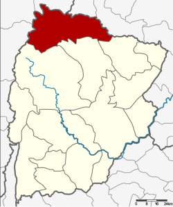
Amphoe Khon San
|
Khon San คอน สาร |
|
|---|---|
| Province: | Chaiyaphum |
| Surface: | 966.665 km² |
| Residents: | 61,942 (2013) |
| Population density : | 60.9 U / km² |
| ZIP : | 36180 |
| Geocode : | 3613 |
| map | |

|
|
Amphoe Khon San ( Thai : อำเภอ คอน สาร ) is a district ( Amphoe - administrative district) in the north of the province of Chaiyaphum . The province of Chaiyaphum is located in the northeast region of Thailand , the so-called Isan .
geography
Neighboring districts (clockwise from north): Phu Pha Man and Chum Phae in Khon Kaen Province , Phu Khiao , Kaset Sombun and Nong Bua Daeng in Chaiyaphum Province , and Mueang Phetchabun , Lom Sak and Nam Nao in Amphoe the province of Phetchabun .
In the south of the district is the Phu Khiao wildlife sanctuary ("Phu Khiao Wildlife Sanctuary").
The Maenam Nam Phrom (Nam Phrom River) is dammed up by the Chulabhorn dam to form an artificial lake about twelve square kilometers in size. The 700 meter long and 70 meter high dam was completed in 1972, it is used for both power generation and irrigation.
history
At the beginning of the Rattanakosin period towards the end of the 18th century, a certain Phumi brought some settlers from the city ( Müang ) Nakhon Thai , at that time part of Phitsanulok, to this area to establish a new settlement here. Mr. Phumi sent tribute payments to King Phra Phutthayotfa Chulalok (Rama I) , who then promoted him to "Muen Aram Kamhaeng". He later became the first governor of Khon San as "Luang Phichit Songkhram".
Since the way from Bangkok to Khon San was very long, the officials had to carry official documents with the Royal Instructions (Thai: San, สาร ) in a kind of litter on their shoulders. This type of wearing is called khon ( คอน ) in Thai .
During the reign of King Chulalongkorn (Rama V) , Khon San was downgraded to a tambon of Phu Khiao district . On August 16, 1958, it was again separated from Phu Khiao to be set up as a "branch circle" ( King Amphoe ) . At that time it consisted of the three tambon Khon San, Nun Khun and Thung Phra. On December 10, 1959, Khon San officially got full Amphoe status.
administration
Provincial Administration
The district of Khon San is divided into eight tambon ("subdistricts" or "parishes"), which are further subdivided into 85 muban ("villages").
| No. | Surname | Thai | Muban | Pop. |
|---|---|---|---|---|
| 1. | Khon San | คอน สาร | 9 | 8,438 |
| 2. | Thung Phra | ทุ่ง พระ | 10 | 5,631 |
| 3. | Non khun | โนน คูณ | 11 | 7,898 |
| 4th | Huai Yang | ห้วย ยาง | 19th | 15,345 |
| 5. | Thung Luilai | ทุ่ง ลุย ลาย | 7th | 6,170 |
| 6th | Dong bang | ดง บัง | 9 | 5,481 |
| 7th | Thung Na Lao | ทุ่ง นา เลา | 11 | 6,620 |
| 8th. | Dong sound | ดง กลาง | 9 | 6,359 |
Local administration
There are three municipalities with "small town" status ( Thesaban Tambon ) in the district:
- Huai Yang (Thai: เทศบาล ตำบล ห้วย ยาง ) consists of the whole tambon Huai Yang.
- Thung Luilai (Thai: เทศบาล ตำบล ทุ่ง ลุย ลาย ) consists of the whole tambon Thung Luilai.
- Khon San (Thai: เทศบาล ตำบล คอน สาร ) consists of parts of the tambon Khon San and Dong Bang.
There are also six " Tambon Administrative Organizations " ( องค์การ บริหาร ส่วน ตำบล - Tambon Administrative Organizations, TAO):
- Khon San (Thai: องค์การ บริหาร ส่วน ตำบล คอน สาร )
- Thung Phra (Thai: องค์การ บริหาร ส่วน ตำบล ทุ่ง พระ )
- Non Khun (Thai: องค์การ บริหาร ส่วน ตำบล โนน คูณ )
- Dong Bang (Thai: องค์การ บริหาร ส่วน ตำบล ดง บัง )
- Thung Na Lao (Thai: องค์การ บริหาร ส่วน ตำบล ทุ่ง นา เลา )
- Dong Klang (Thai: องค์การ บริหาร ส่วน ตำบล ดง กลาง )
Individual evidence
- ↑ ประกาศ กระทรวง มหาดไทย เรื่อง ยก ฐานะ ตำบล ขึ้น เป็น กิ่ง อำเภอ . In: Royal Gazette . 75, No. 72 ง , September 16 1958, p. 2539.
- ↑ พระราชกฤษฎีกา ตั้ง อำเภอ ชุมพวง อำเภอ เชียงยืน อำเภอ แก้ง ค ร้ อ อำเภอ สำโรงทาบ อำเภอ คอน สาร อำเภอ เซกา อำเภอ ทุ่งเสลี่ยม อำเภอ บ้าน ด่าน ด่าน อำเภอ ขนอม อำเภอ บ้านแพรก อำเภอ กระทู้ และ อำเภอ คลองใหญ่ พ.ศ. ๒๕๐๒ . In: Royal Gazette . 76, No. 113 ก ฉบับ พิเศษ (special), December 10 1959, pp. 8-11.
- ↑ 2013 population statistics ( Thai ) Department of Provincial Administration. Retrieved July 28, 2014.
Web links
Coordinates: 16 ° 37 ' N , 101 ° 55' E
