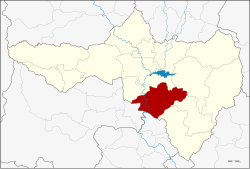
Phayuha Khiri district
|
Phayuha Khiri พยุหะคีรี |
|
|---|---|
| Province: | Nakhon Sawan |
| Surface: | 740.8 km² |
| Residents: | 62,321 (2013) |
| Population density : | 84.7 U / km² |
| ZIP : | 60130 |
| Geocode : | 6010 |
| map | |

|
|
Amphoe Phayuha Khiri ( Thai : อำเภอ พยุหะคีรี ) is a district ( Amphoe - administrative district) of the Nakhon Sawan Province . Nakhon Sawan Province is located in the southern part of the northern region of Thailand .
geography
Neighboring districts (from north clockwise): the Amphoe Krok Phra , Mueang Nakhon Sawan , Tha Tako , Tak Fa and Takhli of the province of Nakhon Sawan, as well as Amphoe Manorom of the province of Chai Nat and Amphoe Mueang Uthai Thani of the province of Uthai Thani .
history
Phayuha Khiri is an ancient city. It was located between the two large cities of Phra Bang (now Nakhon Sawan ) and Chai Nat Buri (now Chai Nat ). It was also on the standard route of the military troops of the kingdoms of Sukhothai and Ayutthaya .
education
The Nakhon Sawan campus of Mahidol University is located in the Phayuha Khiri district .
administration
Provincial Administration
The district of Phayuha Khiri is divided into eleven tambon ("subdistricts" or "communities"), which are further subdivided into 125 muban ("villages").
| No. | Surname | Thai | Muban | Pop. |
|---|---|---|---|---|
| 1. | Phayuha | พยุหะ | 9 | 10,747 |
| 2. | Noen Makok | เนิน มะกอก | 12 | 5,808 |
| 3. | Nikhom Khao Bo Kaeo | นิคม เขา บ่อ แก้ว | 16 | 6,375 |
| 4th | Muang Hak | ม่วง หัก | 10 | 2,287 |
| 5. | Yang Khao | ยาง ขาว | 9 | 3,909 |
| 6th | Yan Matsi | ย่าน มั ท รี | 7th | 4,735 |
| 7th | Khao Thong | เขา ทอง | 12 | 7,468 |
| 8th. | Tha Nam Oi | ท่า น้ำอ้อย | 8th | 2,837 |
| 9. | Nam Song | น้ำ ทรง | 11 | 6,387 |
| 10. | Khao Kala | เขา กะลา | 19th | 8,554 |
| 11. | Sa Thale | สระ ทะเล | 12 | 3.214 |
Local administration
There are two municipalities with "small town" status ( Thesaban Tambon ) in the district:
- Tha Nam Oi Muang Hak (Thai: เทศบาล ตำบล ท่า น้ำอ้อย ม่วง หัก ) consisting of the complete Tambon Muang Hak, Tha Nam Oi.
- Phayuha (Thai: เทศบาล ตำบล พยุหะ ) consisting of parts of the Tambon Phayuha.
In addition, there are nine " tambon administration organizations " ( องค์การ บริหาร ส่วน ตำบล - Tambon Administrative Organizations, TAO)
- Phayuha (Thai: องค์การ บริหาร ส่วน ตำบล พยุหะ ) consisting of parts of the Tambon Phayuha.
- Noen Makok (Thai: องค์การ บริหาร ส่วน ตำบล เนิน มะกอก ) consisting of the complete Noen Makok tambon.
- Nikhom Khao Bo Kaeo (Thai: องค์การ บริหาร ส่วน ตำบล นิคม เขา บ่อ แก้ว ) consisting of the complete tambon Nikhom Khao Bo Kaeo.
- Yang Khao (Thai: องค์การ บริหาร ส่วน ตำบล ยาง ขาว ) consisting of the complete tambon Yang Khao.
- Yan Matsi (Thai: องค์การ บริหาร ส่วน ตำบล ย่าน มั ท รี ) consisting of the complete tambon Yan Matsi.
- Khao Thong (Thai: องค์การ บริหาร ส่วน ตำบล เขา ทอง ) consisting of the complete Tambon Khao Thong.
- Nam Song (Thai: องค์การ บริหาร ส่วน ตำบล น้ำ ทรง ) consisting of the complete Tambon Nam Song.
- Khao Kala (Thai: องค์การ บริหาร ส่วน ตำบล เขา กะลา ) consisting of the complete Tambon Khao Kala.
- Sa Thale (Thai: องค์การ บริหาร ส่วน ตำบล สระ ทะเล ) consisting of the complete tambon Sa Thale.
Individual evidence
- ↑ 2013 population statistics ( Thai ) Department of Provincial Administration. Retrieved October 28, 2014.
Web links
Coordinates: 15 ° 29 ' N , 100 ° 8' E
