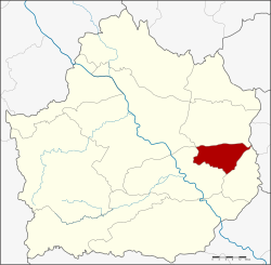
Sai Thong Watthana district
|
Sai Thong Watthana ทราย ทอง วัฒนา |
|
|---|---|
| Province: | Kamphaeng Phet |
| Surface: | 253 km² |
| Residents: | 23,572 (2013) |
| Population density : | 95 U / km² |
| ZIP : | 62190 |
| Geocode : | 6208 |
| map | |

|
|
Amphoe Sai Thong Watthana ( Thai : อำเภอ ทราย ทอง วัฒนา ) is a district ( Amphoe - administrative district) in the east of Kamphaeng Phet Province . The Kamphaeng Phet Province is located in the northern region of Thailand .
geography
Amphoe Sai Thong Watthana has only a very narrow border to the neighboring province of Phichit ; from the south it borders clockwise to the Amphoe Bueng Samakkhi , Khlong Khlung and Sai Ngam of the province of Kamphaeng Phet and to Amphoe Sam Ngam of the province of Phichit .
history
On April 1, 1992, Sai Thong Watthana was initially founded as a "branch circle" ( King Amphoe ) by removing three tambon from Khlong Khlung . Originally the King Amphoe was called Thung Sai (sandbag) after the central tambon. In 1995 the district got its current name Sai Thong Watthana. On October 11, 1997, it was upgraded to a full amphoe.
administration
Provincial Administration
Sai Thong Watthana County is divided into three tambon ("subdistricts" or "parishes"), which are further subdivided into 38 muban ("villages").
| No. | Surname | Thai | Muban | Pop. |
|---|---|---|---|---|
| 1. | Thung Sai | ทุ่ง ทราย | 17th | 9,699 |
| 2. | Thung Thong | ทุ่ง ทอง | 11 | 7,247 |
| 3. | Thawon Watthana | ถาวร วัฒนา | 10 | 6,626 |
Local administration
There is one municipality with "small town" status ( Thesaban Tambon ) in the district:
- Thung Sai (Thai: เทศบาล ตำบล ทุ่ง ทราย ) consisting of the complete tambon Thung Sai.
There are also two " tambon administration organizations " ( องค์การ บริหาร ส่วน ตำบล - Tambon Administrative Organizations, TAO)
- Thung Thong (Thai: องค์การ บริหาร ส่วน ตำบล ทุ่ง ทอง ) consisting of the complete Tambon Thung Thong.
- Thawon Watthana (Thai: องค์การ บริหารส่วน ตำบล ถาวร วัฒนา ) consisting of the complete tambon Thawon Watthana.
Individual evidence
- ↑ ประกาศ กระทรวง มหาดไทย เรื่อง แบ่ง เขต ท้องที่ อำเภอ คลองขลุง จังหวัด กำแพงเพชร ตั้ง เป็น กิ่ง อำเภอ ทุ่ง ทราย Royal Gazette, Volume 109. Ed. 53 ง special ( ฉบับ พิเศษ ) of April 22, 1992, p. 3 (in Thai)
- ↑ ประกาศ กระทรวง มหาดไทย เรื่อง เปลี่ยนแปลง ชื่อ กิ่ง อำเภอ ทุ่ง ทราย อำเภอ คลองขลุง จังหวัด กำแพงเพชร Royal Gazette, Volume 113, Issue 19 ง of March 5, 1996, p. 4 (in Thai)
- ↑ พระราชกฤษฎีกา ตั้ง อำเภอ หนอง ปรือ อำเภอ ห้วย กระเจา อำเภอ ทราย ทอง วัฒนา อำเภอ ปาง ศิลา ทอง อำเภอ เนิน สง่า อำเภอ นา ทม อำเภอ พระ พรหม อำเภอ แม่ แม่ วงก์ อำเภอ สอง แคว อำเภอ บ้าน ใหม่ ไชย พจน์ อำเภอ ไทย เจริญ อำเภอ กา บัง อำเภอ พยุ จันทร์ อำเภอ เมือง เมือง เมือง เมือง เมือง เมือง เมือง ภู พาน อำเภอ คลอง หอยโข่ง อำเภอ เขา ฉกรรจ์ อำเภอ นา วัง อำเภอ พิบูลย์ รักษ์ และ อำเภอ ทุ่ง ศรี อุดม พ.ศ. ๒๕๔๐ Royal Gazette, Volume 114, Ed. 50 ก of September 26, 1997, pp. 24-27 (in Thai)
- ↑ 2013 population statistics ( Thai ) Department of Provincial Administration. Retrieved October 26, 2014.
Web links
Coordinates: 16 ° 19 ′ N , 99 ° 50 ′ E
