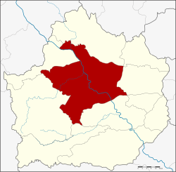
Amphoe Mueang Kamphaeng Phet
|
Mueang Kamphaeng Phet เมือง กำแพงเพชร |
|
|---|---|
| Province: | Kamphaeng Phet |
| Surface: | 1,962.0 km² |
| Residents: | 212,663 (2013) |
| Population density : | 108.1 U / km² |
| ZIP : | 62000, 62160 |
| Geocode : | 6201 |
| map | |

|
|
Amphoe Mueang Kamphaeng Phet ( Thai : อำเภอ เมือง กำแพงเพชร ) is a district ( Amphoe - Administrative District) in the Province of Kamphaeng Phet . The Kamphaeng Phet Province is located in the northern region of Thailand .
geography
Neighboring districts (from northwest clockwise): the amphoe Kosamphi Nakhon , Phran Kratai , Sai Ngam , Khlong Khlung and Khlong Lan of the province Kamphaeng Phet and Amphoe Wang Chao of the province Tak .
history
In 1917, Mueang County was renamed Mueang Kamphaeng Phet.
education
The Rajabhat University of Kamphaeng Phet is located in Amphoe Mueang Kamphaeng Phet .
Culture
In Amphoe Mueang Kamphaeng Phet is the Kamphaeng Phet Historical Park , which is a UNESCO World Heritage Site. Opposite the town of Kamphaeng Phet on the other bank of the Ping River is the small town of Nakhon Chum. Here is Wat Phra Borommathat Chediyaram, the notable feature of which is a gilded Burmese-style chedi .
administration
Provincial Administration
Mueang Kamphaeng Phet County is divided into 16 tambon ("subdistricts" or "parishes"), which are further subdivided into 220 muban ("villages").
| No. | Surname | Thai | Muban | Pop. |
|---|---|---|---|---|
| 1. | Nai Mueang | ใน เมือง | - | 29,117 |
| 2. | Trai Trueng | ไตรตรึงษ์ | 15th | 15.176 |
| 3. | Ang Thong | อ่างทอง | 21st | 18,040 |
| 4th | Well Bo Kham | นา บ่อ คำ | 22nd | 20.114 |
| 5. | Nakhon Chum | นคร ชุม | 13 | 17,456 |
| 6th | Song Tham | ทรงธรรม | 12 | 7,516 |
| 7th | Lan Dokmai | ลาน ดอกไม้ | 11 | 6,851 |
| 10. | Nong Pling | หนอง ปลิง | 11 | 12,113 |
| 11. | Khonthi | ค ณ ฑี | 13 | 9,744 |
| 12. | Nikhom Thung Pho Thale | นิคม ทุ่ง โพธิ์ ทะเล | 16 | 9,365 |
| 13. | Thep Nakhon | เทพ นคร | 22nd | 20,348 |
| 14th | Wang Thong | วังทอง | 21st | 10,817 |
| 15th | Tha Khun Ram | ท่า ขุน ราม | 13 | 9,068 |
| 17th | Khlong Mae Lai | คลอง แม่ลาย | 10 | 7,458 |
| 18th | Thammarong | ธำมรงค์ | 8th | 4,501 |
| 19th | Sa Kaeo | สระแก้ว | 12 | 14,979 |
Local administration
There are two municipalities with "city" status ( Thesaban Mueang ) in the district:
- Nong Pling (Thai: เทศบาล เมือง หนอง ปลิง ) consisting of the complete Tambon Nong Pling.
- Kamphaeng Phet (Thai: เทศบาล เมือง กำแพงเพชร ) consisting of the complete Tambon Nai Mueang.
There are five municipalities with "small town" status ( Thesaban Tambon ) in the district:
- Khlong Mae Lai (Thai: เทศบาล ตำบล คลอง แม่ลาย ) consisting of the parts of the Tambon Ang Thong, Khlong Mae Lai.
- Nakhon Chum (Thai: เทศบาล ตำบล นคร ชุม ) consisting of parts of the Tambon Nakhon Chum.
- Pak Dong (Thai: เทศบาล ตำบล ปาก ดง ) consisting of parts of the Tambon Trai Trueng.
- Thep Nakhon (Thai: เทศบาล ตำบล เทพ นคร ) consisting of the complete tambon Thep Nakhon.
- Nikhom Thung Pho Thale (Thai: เทศบาล ตำบล นิคม ทุ่ง โพธิ์ ทะเล ) consisting of the complete Tambon Nikhom Thung Pho Thale.
In addition, there are twelve " tambon administration organizations " ( องค์การ บริหาร ส่วน ตำบล - Tambon Administrative Organizations, TAO)
- Trai Trueng (Thai: องค์การ บริหารส่วน ตำบล ไตรตรึงษ์ ) consisting of parts of the tambon Trai Trueng.
- Ang Thong (Thai: องค์การ บริหาร ส่วน ตำบล อ่างทอง ) consisting of parts of the Tambon Ang Thong.
- Na Bo Kham (Thai: องค์การ บริหาร ส่วน ตำบล นา บ่อ คำ ) consisting of the complete tambon Na Bo Kham.
- Nakhon Chum (Thai: องค์การ บริหาร ส่วน ตำบล นคร ชุม ) consisting of parts of the Tambon Nakhon Chum.
- Song Tham (Thai: องค์การ บริหาร ส่วน ตำบล ทรงธรรม ) consisting of the complete tambon Song Tham.
- Lan Dokmai (Thai: องค์การ บริหารส่วน ตำบล ลาน ดอกไม้ ) consisting of the complete Tambon Lan Dokmai.
- Khonthi (Thai: องค์การ บริหาร ส่วน ตำบล ค ณ ฑี ) consisting of the complete tambon Khonthi.
- Wang Thong (Thai: องค์การ บริหาร ส่วน ตำบล วังทอง ) consisting of the complete tambon Wang Thong.
- Tha Khun Ram (Thai: องค์การ บริหาร ส่วน ตำบล ท่า ขุน ราม ) consisting of the complete tambon Tha Khun Ram.
- Khlong Mae Lai (Thai: องค์การ บริหาร ส่วน ตำบล คลอง แม่ลาย ) consisting of parts of the tambon Khlong Mae Lai.
- Thammarong (Thai: องค์การ บริหาร ส่วน ตำบล ธำมรงค์ ) consisting of the complete tambon Thammarong.
- Sa Kaeo (Thai: องค์การ บริหาร ส่วน ตำบล สระแก้ว ) consisting of the complete Sa Kaeo tambon.
Web links
Individual evidence
- ↑ ประกาศ กระทรวง มหาดไทย เรื่อง เปลี่ยน ชื่อ อำเภอ . In: Royal Gazette . 34, No. 0 ก , April 29, 1917, pp. 40-68.
- ↑ 2013 population statistics ( Thai ) Department of Provincial Administration. Retrieved October 26, 2014.
Coordinates: 16 ° 29 ' N , 99 ° 31' E

