
Tossa (river)
| Riera de Tossa | ||
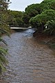
 Course of the Tossa River in the city |
||
| Data | ||
| location | Catalonia , Spain | |
| River system | Tossa | |
| River basin district | Cuencas Internas de Cataluña | |
| source | in the massif of the Cadiretes 41 ° 45 ′ 23 ″ N , 2 ° 52 ′ 55 ″ E |
|
| Source height | 400 msnm | |
| muzzle | near Tossa de Mar in the Mediterranean Coordinates: 41 ° 43 ′ 3 " N , 2 ° 56 ′ 2" E 41 ° 43 ′ 3 " N , 2 ° 56 ′ 2" E |
|
| Mouth height | 0 msnm | |
| Height difference | 400 m | |
| Bottom slope | 33 ‰ | |
| length | 12 km | |
| Navigable | No | |
The river Tossa ( Riera de Tossa ) rises in the massif of the Cadiretes , flows through the Spanish autonomous community of Catalonia and flows into the sea at Tossa de Mar. While the river mostly falls dry in the urban area in the summer months, it is a torrential river after rainfall.
After a few kilometers through the forests of the coastal mountains, the Massís de l'Ardenya , the river reaches the Tossa valley, which is also used for agriculture. The river now runs parallel to the GI-681 road from Tossa to Llagostera . 2 kilometers before the entrance to Tossa, the river flows past the holiday complex Sant Eloy, which is designed as a medieval castle.
600 meters from the city, the river flows through the Parc de Sa Riera . This park, which was created in 1998 and has an area of 15,000 square meters, serves the tourist development of the fallow land that was next to the city's water treatment plant. The modernization of the water treatment plant has meant that the river in the park area has not dried up since then, even in the summer months. As a result, the park was ecologically upgraded and now also offers a habitat for water birds and animals.
The renovation was combined with the creation of a picnic area with benches and a fitness area, which enables various sports exercises.
As a result, the river flows past the municipal indoor swimming pool and the city's sports facilities. In the urban area, the river follows the Avignuda de Cataluniya, the main axis of the city. Upon reaching the main beach, the river changes direction. Instead of walking the last few meters to the sea, it turns and flows parallel to the beach promenade until it pours into the sea below the city wall.
In the area of the city center there are only pedestrian bridges over the river. Two road crossings are designed as fords and closed when the river carries water.
The strongly changing water levels require flood precautions for the residents. A number of business entrances near the river are therefore regularly partially bricked up in the winter season to prevent water from entering. The erosion in the area of the beach leads to the regular need for the main beach to be reconditioned by the municipality.
Course on the Avignuda de Cataluniya

Ford downtown

Course in front of the beach promenade
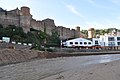
River in front of the castle


