Sangkhla Buri district
|
Sangkhla Buri สังขละบุรี |
|
|---|---|
| Province: | Kanchanaburi |
| Surface: | 3349.4 km² |
| Residents: | 38,395 (2013) |
| Population density : | 13 U / km² |
| ZIP : | 71240 |
| Geocode : | 7108 |
| map | |

|
|
Amphoe Sangkhla Buri (also Sangkhaburi, Thai อำเภอ สังขละบุรี ) is a district ( Amphoe - administrative district) in the northern part of Kanchanaburi Province .
Kanchanaburi Province is located in the west of the central region of Thailand on the border with Myanmar (Burma).
geography
The neighboring counties and areas are clockwise from the west: Tanintharyi Division , Mon State and Kayin State of Myanmar, Amphoe Umphang of ( Tak Province ), and Amphoe Thong Pha Phum of Kanchanaburi Province.
Amphoe Sangkhla Buri is crossed by the mountains of the Tenasserim chain and is mostly densely forested. The population density is very low with 13 inhabitants / km². There are no bigger cities. Numerous rivers originate in the mountains, most of which feed the Vajiralongkorn Reservoir , the northern part of which is in this district and which flows into the Mae Nam Khwae Noi (Khwae Noi River) .
The northern part of the Khao Laem National Park and the southwestern part of the Thung Yai Naresuan wildlife sanctuary are located in Amphoe Sangkhla Buri .
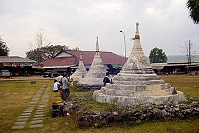
Amphoe Sangkhla Buri has a border crossing to Myanmar at the Three Pagoda Pass , which has played a role several times in the history of the two countries.
history
In 1939, Wang Ka ( วัง กะ ) County was renamed Sangkhla Buri. This name previously belonged to the "branch circle" ( King Amphoe ) Thong Pha Phum. On May 20, 1949, the district was downgraded to "Branch District" (King Amphoe) and assigned to Thong Pha Phum County. At that time the Tambon Nong Lu, Prangphle, Laiwo and Lang Phu Sa belonged to the county. On July 27, 1965, he was raised again to Amphoe status.
economy
- Selected OTOP products from the district
- Brushwood
- "Fish products", baked bananas
- Rice wine, galangal wine (from Kaempferia pandurata )
Attractions
- Wat Wang Wiwekaram ( วัด วังก์ วิ เว กา ราม ) - an old Buddhist temple ( Wat ) belonging to the Mon ethnic group is located on the banks of the Vajiralongkorn reservoir. The large Chedi Phutthakaya is modeled on the Mahabodhi temple in Bodhgaya in the northeastern Indian state of Bihar .
administration
Provincial Administration
Sangkhla Buri County is divided into three tambon ("subdistricts" or "parishes"), which are further divided into 20 muban ("villages").
| No. | Surname | Thai | Muban | Pop. |
|---|---|---|---|---|
| 1. | Nong Lu | หนอง ลู | 10 | 28,291 |
| 2. | Prang Phle | ปรัง เผล | 4th | 5,377 |
| 3. | Laiwo | ไล่ โว่ | 6th | 4,727 |
Local administration
There is one municipality with "small town" status ( Thesaban Tambon ) in the district:
- Wang Ka (Thai: เทศบาล ตำบล วัง กะ ) consisting of parts of the Tambon Nong Lu.
There are also three " tambon administration organizations " ( องค์การ บริหาร ส่วน ตำบล - Tambon Administrative Organizations, TAO)
- Nong Lu (Thai: องค์การ บริหาร ส่วน ตำบล หนอง ลู ) consisting of parts of the Tambon Nong Lu.
- Prang Phle (Thai: องค์การ บริหาร ส่วน ตำบล ปรัง เผล ) consisting of the complete Tambon Prang Phle.
- Laiwo (Thai: องค์การ บริหารส่วน ตำบล ไล่ โว่ ) consisting of the complete Tambon Laiwo.
Individual evidence
- ↑ พระราชกฤษฎีกา เปลี่ยน นาม อำเภอ กิ่ง อำเภอ และ ตำบล บาง แห่ง พุทธศักราช ๒๔๘๒ . In: Royal Gazette . 56, No. 0 ก , April 17 1939, pp. 354-364.
- ↑ ประกาศ สำนัก นายกรัฐมนตรี เรื่อง ยก ฐานะ กิ่ง อำเภอ ขึ้น เป็น อำเภอ และ ยุบ อำเภอ ลง เป็น กิ่ง จังหวัด กาญจนบุรี . In: Royal Gazette . 58, No. 0 ง , May 20 1941, p. 1238.
- ↑ พระราชกฤษฎีกา ตั้ง อำเภอ ศรีสวัสดิ์ อำเภอ สังขละบุรี อำเภอ ท่าคันโท อำเภอ ดอกคำใต้ อำเภอ แม่ใจ อำเภอ จุน อำเภอ ขามทะเลสอ อำเภอ ไพศาลี อำเภอ ท่าวังผา อำเภอ บ้านกรวด อำเภอ เด่นชัย เด่นชัย อำเภอ ปทุม รัตน์ อำเภอ กะเปอร์ อำเภอ อำเภอ อากาศอำนวย อำเภอ ดอนเจดีย์ อำเภอ จอมพระ และ อำเภอ สามโก้ พ.ศ. ๒๕๐๘ Royal Gazette, Vol. 81, Issue 49 ก July 27, 1965, p. 565- (in Thai)
- ↑ Illustrated list of selected OTOP products in the district (in Thai)
- ↑ 2013 population statistics ( Thai ) Department of Provincial Administration. Retrieved September 10, 2014.
Web links
- Sangkhlaburi - the cultural cross roads of Kanchanaburi - TAT's English-language websiteabout Sangkhla Buri
- More information on Amphoe Sangkhla Buri from amphoe.com (in Thai; last accessed December 1, 2015)
Coordinates: 15 ° 9 ' N , 98 ° 27' E


