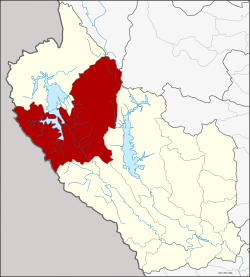
Amphoe Thong Pha Phum
|
Amphoe Thong Pha Phum อำเภอ ทองผาภูมิ |
|
|---|---|
| Province: | Kanchanaburi |
| Surface: | 3,655.2 km² |
| Residents: | 58,334 (2013) |
| Population density : | 18 U / km² |
| ZIP : | 71180 |
| Geocode : | 7107 |
| map | |

|
|
Amphoe Thong Pha Phum ( Thai : อำเภอ ทองผาภูมิ ) is a district ( Amphoe - administrative district) in the northern part of Kanchanaburi Province . Kanchanaburi Province is located in the west of the central region of Thailand on the border with Myanmar .
geography
The adjacent counties are (from the west in the clockwise) Tanintharyi Division in Myanmar , Sangkhla Buri District Kanchanaburi province, Umphang the province Tak , Ban Rai District the province Uthai Thani and the Amphoe Si Sawat and Sai Yok again from the Kanchanaburi Province.
The main water resource is the Mae Nam Khwae Yai ( Khwae Yai River - "Great Tributary", world-famous as the River Kwai ).
history
Thong Pha Phum County was initially established in 1902 as a “Branch County” ( King Amphoe ) of Sangkhla Buri, Wang Ka County. In 1939, Wang Ka was renamed Sangkhla Buri, while Wang Ka was renamed Thong Pha Phum. On May 20, 1941, Thong Pha Phum was given full amphoe status, while Sangkhlaburi was downgraded to a subdistrict. At that time, the district initially consisted of the six Tambon Tha Khanun, Hin Dat, Dika, Chalae, Pilok and Linthin.
economy
Dams
- Vajiralongkorn Dam (Khao Laem Dam) - the system generates around 300 kW. The electricity from the hydropower plant will be delivered to Bangkok.
Others
- Selected OTOP products from the district
- Baked bananas in honey
- Furniture made from "Golden Teakwood" ( Australian silver acacia , Acacia decurrens Willd. )
- Rice wine
- Household items made from woven bamboo
Attractions
The following national parks are located in Thong Pha Phum :
- Thong Pha Phum National Park ( อุทยานแห่งชาติ ทองผาภูมิ ),
- Lam Khlong Ngu National Park ( อุทยานแห่งชาติ ลำคลอง งู ) and
- Khao Laem National Park ( อุทยานแห่งชาติ เขา แหลม ).
administration
Provincial Administration
Thong Pha Phum County is divided into seven tambon ("subdistricts" or "parishes"), which are further subdivided into 45 muban ("villages").
| No. | Surname | Thai | Muban | Pop. |
|---|---|---|---|---|
| 1. | Tha Khanun | ท่า ขนุน | 5 | 16,682 |
| 2. | Pilok | ปิ ล๊ อก | 4th | 5,167 |
| 3. | Hin Dat | หิน ดาด | 8th | 5,140 |
| 4th | Linthin | ลิ่น ถิ่น | 7th | 6,847 |
| 5. | Cha Lae | ชะ แล | 7th | 9,900 |
| 6th | Huai Khayeng | ห้วย เขย่ง | 8th | 9,578 |
| 7th | Sahakon Nikhom | สหกรณ์ นิคม | 6th | 5,020 |
Local administration
There are four municipalities with "small town" status ( Thesaban Tambon ) in the district:
- Tha Khanun (Thai: เทศบาล ตำบล ท่า ขนุน ) consisting of parts of the Tambon Tha Khanun.
- Linthin (Thai: เทศบาล ตำบล ลิ่น ถิ่น ) consisting of the complete tambon Linthin.
- Sahakon Nikhom (Thai: เทศบาล ตำบล สหกรณ์ นิคม ) consisting of the complete tambon Sahakon Nikhom.
- Thong Pha Phum (Thai: เทศบาล ตำบล ทองผาภูมิ ) consisting of parts of the Tambon Tha Khanun.
There are also four " tambon administration organizations " ( องค์การ บริหาร ส่วน ตำบล - Tambon Administrative Organizations, TAO)
- Pilok (Thai: องค์การ บริหาร ส่วน ตำบล ปิ ล๊ อก ) consisting of the complete tambon pilok.
- Hin Dat (Thai: องค์การ บริหาร ส่วน ตำบล หิน ดาด ) consisting of the complete tambon Hin Dat.
- Cha Lae (Thai: องค์การ บริหาร ส่วน ตำบล ชะ แล ) consisting of the complete Tambon Cha Lae.
- Huai Khayeng (Thai: องค์การ บริหารส่วน ตำบล ห้วย เขย่ง ) consisting of the complete tambon Huai Khayeng.
Individual evidence
- ↑ พระราชกฤษฎีกา เปลี่ยน นาม อำเภอ กิ่ง อำเภอ และ ตำบล บาง แห่ง พุทธศักราช ๒๔๘๒ . In: Royal Gazette . 56, No. 0 ก , April 17 1939, pp. 354-364.
- ↑ ประกาศ สำนัก นายกรัฐมนตรี เรื่อง ยก ฐานะ กิ่ง อำเภอ ขึ้น เป็น อำเภอ และ ยุบ อำเภอ ลง เป็น กิ่ง จังหวัด กาญจนบุรี Royal Gazette, Vol. 58, Issue 0 ง of May 20, 1941, p. 1238 (in Thai)
- ↑ List of OTOP from Kanchanaburi (in Thai)
- ↑ Information on the Thong Pha Phum National Park ( Memento of the original from May 22, 2013 in the Internet Archive ) Info: The archive link has been inserted automatically and has not yet been checked. Please check the original and archive link according to the instructions and then remove this notice. (in English)
- ↑ Information on the Lam Khlong Ngu National Park ( Memento of the original from May 22, 2013 in the Internet Archive ) Info: The archive link has been inserted automatically and has not yet been checked. Please check the original and archive link according to the instructions and then remove this notice. (in English)
- ↑ Information on the Khao Laem National Park ( Memento of the original from May 22, 2013 in the Internet Archive ) Info: The archive link has been inserted automatically and has not yet been checked. Please check the original and archive link according to the instructions and then remove this notice. (in English)
- ↑ 2013 population statistics ( Thai ) Department of Provincial Administration. Retrieved September 10, 2014.
Web links
- More information on Amphoe Thong Pha Phum from amphoe.com (in Thai; last accessed December 1, 2015)
Coordinates: 14 ° 45 ' N , 98 ° 37' E
