
Kanchanaburi (Province)
| Kanchanaburi | |
|---|---|
| กาญจนบุรี | |

|
|
| statistics | |
| Capital: | Kanchanaburi |
| Telephone code: | 034 |
| Surface: |
19,483.2 km² 3. |
| Residents: |
833.423 (2009) 31. |
| Population density : | 42 E / km² 74. |
| ISO 3166-2 : | |
| Governor : | |
| map | |
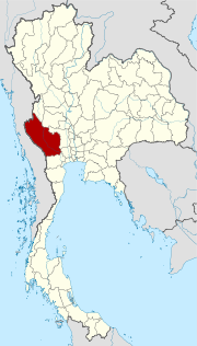  |
|

Kanchanaburi ( Thai : กาญจนบุรี ) is a province ( Changwat ) in the western part of the central region of Thailand . The capital of Kanchanaburi Province is also called Kanchanaburi .
location
Kanchanaburi Province is about 110 kilometers northwest of Bangkok on the border with Myanmar (Burma). The landscape mainly consists of rainforest areas, rugged mountainous landscapes, waterfalls and caves. This is also where the headwaters of the two rivers Mae Nam Khwae Yai and Mae Nam Khwae Noi ("River Kwai") converge near the provincial capital and from there form the Mae Nam Mae Klong (Mae Klong River) .
| Adjacent provinces and areas: | |
|---|---|
| north | Tak and Uthai Thani |
| east | Suphan Buri and Nakhon Pathom |
| south | Ratchaburi |
| west | Land border with Myanmar |
Important rivers
Mae Nam Khwae Yai , Mae Nam Khwae Noi , Mae Nam Mae Klong .
climate
The climate is hot with a lot of rain. The temperatures fluctuate relatively strongly for the conditions in Thailand: maximum temperatures 35 to 19 ° C, minimum temperatures 7 to 20 ° C.
Economy and Importance
General
The fertile landscape enables intensive agriculture: rice , sugar cane and fruit . There are many mines for ores and gemstones in the mountains .
The area around Kanchanaburi is a popular destination for the people of Bangkok and is also visited by many tourists who see the natural beauties and the famous bridge over the Kwai and the memorials for the victims of the construction of the Thailand-Burma railway .
In 2011, the "Gross Provincial Product" (was GDP ) of the province 76.269 billion baht , equivalent to 95,744 baht per inhabitant.
The industry that contributed the most to the province's economic output in 2011 was manufacturing with 22.987 billion baht, followed by agriculture with 17.025 billion baht, wholesale and retail with 7.357 billion baht, and administration, defense and mandatory social security 6.652 billion baht.
Dams

- Si Nakharin Dam (Amphoe Si Sawat) - 64 km west of the provincial capital, near the Erawan Waterfall; the plant generates approx. 720 MW.
- Tha Thung Na - regulation dam, which is also used for irrigation, generates 38 MW
- Khao Laem (Amphoe Thong Pha Phum) - the plant generates approx. 300 MW; an old Mon temple complex with Buddha shrines stands on the bank of the reservoir
Electricity from the hydropower plants is supplied to Bangkok.
history
The Stone Age settlement of the area has been proven and can be visited in Ban Kao , see Ban Kao National Museum .
During the reign of King Rama I (r. 1782-1809) a comprehensive tax system was introduced, including for alcohol. Kanchanaburi was administered together with Ratchaburi and Samut Songkhram . Thailand was repeatedly threatened by the Burmese, who invaded via the Three Pagoda Pass , devastated the country and took people with them as cheap labor. Therefore, fortified posts were built in the 1820s and were occupied by Mon. They were allowed to settle their families here, but because of the recurring malaria , they were more likely to leave them at home. The leader was Phaya Mahayotha, a son of General Cheng. They felled redwood ( ไม้ ฝาง , English: sapanwood) on behalf of the governor and made it to Bangkok.

The province gained worldwide fame through the film " The Bridge on the River Kwai ", which was built over the Mae Klong near the provincial capital. During World War II , the Japanese planned a railroad across Southeast Asia to bypass the dangerous sea route through the Strait of Malacca . A prison camp was built and filled with British, American, French, Dutch and other prisoners who had to build the railroad. Several thousand people were killed.
archeology
Several archaeological sites have been discovered in the province, including Sai Yok ( Amphoe Sai Yok ) and the Khao Thalu Cave in Tambon Ban Kao.
Attractions


Museums
- Ban Kao National Museum - about 35 kilometers northwest of the provincial capital; stone age burial site showing remains and tools
- Mueang Sing - historical park that houses the Prang Prasat Mueang Sing, the westernmost Khmer ruins in Thailand
- Chong Kai War Cemetery ( สุสาน ทหาร สัมพันธมิตร เขา ปูน - Khao Pun War Cemetery) - just outside, southwest of the provincial capital, lies the war cemetery on the west bank of the Mae Nam Khwae Noi
- JEATH-Museum - prisoner museum for the Death Railway inside Wat Chai Chumphon
temple
- Wat Tham Mankhon Thong ( วัด ถ้ำ วัง มังกร ทอง ) - Buddhist temple complex ( Wat ) , which is partially located on a mountain, from which there is an impressive panorama
National parks
- Sai Yok National Park - with the Wang Pho Bridge over the Mae Nam Khwae Noi , nearby a forest area with caves and the pig- nosed bat , the smallest bat in the world
- Erawan National Park , 550 square kilometers; with the famous Erawan waterfall, which extends over 1500 meters and seven steps, as well as stalactite caves (the most interesting at Tham Phra Thai)
Symbols

The seal shows three chedis from the mountains of Ban Thad Thong at the Three Pagoda Pass to Myanmar, which in the past was one of the most important transport links from the trading cities on the Indian Ocean to Siam .
The local flower is jasmine ( Nycthantes arbortristis ). The local tree is the lancewood ( Homalium tomentosum ). Kanchanaburi Province's motto is:
- Kanchanaburi is famous for its old town,
- Khun Phaen, a character of Thai literature, lived here in his homeland,
- The land of the Three Pagoda Pass,
- Rich in precious stones and minerals , not made of glass,
- Famous for the bridge on the river Kwai,
- Many waterfalls can be seen.
Administrative units
Provincial Administration
The province is divided into 13 districts ( Amphoe ). The districts are further subdivided into 98 parishes ( tambon ) and 887 villages ( muban ).
|

Local administration
A provincial administrative organization ( บริหาร ส่วน จังหวัด , อบ จ for short , Ongkan Borihan suan Changwat ; English Provincial Administrative Organization , PAO) exists for the entire area of the province .
In the area of the province there are two “cities” ( เทศบาล เมือง - Thesaban Mueang ), Kanchanaburi ( เทศบาล เมือง กาญจนบุรี ) and Tha Ruea Phra Thaen ( เทศบาล เมือง Gebiet พระแท่น ). There are also 31 “small towns” ( เทศบาล ตำบล - Thesaban Tambon ).
Individual evidence
- ^ A b Gross Provincial Product at Current Market Prices: Western Provinces, National Economic and Social Development Board, 2011.
- ↑ Terwiel (1989), p. 72.
- ↑ Terwiel (1989), p. 96f.
- ↑ Department of Provincial Administration , as of 2012 (in Thai)
literature
- Barend Jan Terwiel : Trough Travelers' Eyes: an approach to nineteenth century Thai history . Duang Kamol, Bangkok 1989, ISBN 974-210-455-7 .
- Thailand in Figures . 13th edition. Alpha Research Nonthaburi 2011, ISBN 978-616-7526-03-4 .
Web links
- Overview map of the province (names in English and Thai) [last accessed on November 4, 2013]
North : Chiang Mai | Chiang Rai | Kamphaeng Phet | Lampang | Lamphun | Mae Hong Son | Nakhon Sawan | Nan | Phayao | Phetchabun | Phichit | Phitsanulok | Phrae | Sukhothai | Tak | Uthai Thani | Uttaradit
Northeast : Amnat Charoen | Bueng Kan | Buri Ram | Chaiyaphum | Kalasin | Khon Kaen | Loei | Maha Sarakham | Mukdahan | Nakhon Phanom | Nakhon Ratchasima | Nong Bua Lam Phu | Nong Khai | Roi Et | Sakon Nakhon | Si Sa Ket | Surin | Ubon Ratchathani | Udon Thani | Yasothon
Central : Ang Thong | Ayutthaya | Bangkok | Chachoengsao | Chai Nat | Chanthaburi | Chon Buri | Kanchanaburi | Lop Buri | Nakhon Nayok | Nakhon Pathom | Nonthaburi | Pathum Thani | Phetchaburi | Prachin Buri | Prachuap Khiri Khan | Ratchaburi | Rayong | Sa Kaeo | Samut Prakan | Samut Sakhon | Samut Songkhram | Saraburi | Sing Buri | Suphan Buri | Stepped
South : Chumphon | Krabi | Nakhon Si Thammarat | Narathiwat | Pattani | Phang-nga | Phatthalung | Phuket | Ranong | Satun | Songkhla | Surat Thani | Trang | Yala
Coordinates: 14 ° 40 ′ N , 99 ° 1 ′ E