
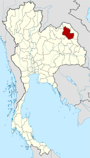
Sakon Nakhon Province
| Sakon Nakhon | |
|---|---|
| สกลนคร | |

|
|
| statistics | |
| Capital: | Sakon Nakhon |
| Telephone code: | 042 |
| Surface: |
9,605.8 km² 19. |
| Residents: |
1,118,449 (2009) 16. |
| Population density : | 115 E / km² 43. |
| ISO 3166-2 : | |
| Governor : | |
| map | |
  |
|

Sakon Nakhon ( Thai : สกลนคร ) is a province ( Changwat ) in the northeast region of Thailand , the Isan . The capital of the province is also called Sakon Nakhon .
origin of the name
Provinces in Thailand are named after the respective provincial capital. Sakon comes from the Sanskrit sakala (Devanagari: सकल) and means whole, all-embracing, and Nakhon comes from the Sanskrit nagara (Devanagari: नगर) meaning city. In other words, Sakon Nakhon means city of cities.
geography

The province is located in the upper northeast of Thailand and is closed off to the south by the Phu Phan Mountains . Several important rivers have their source here. In the wooded mountains there are numerous forest temples, some of which date from the Khmer period. The Lake Nong Han is with an area of about 125 square kilometers the largest natural freshwater lake in Thailand.
| Neighboring provinces: | |
|---|---|
| north | Nong Khai and Bueng Kan |
| east | Nakhon Phanom |
| south | Mukdahan and Kalasin |
| west | Udon Thani |
Important cities
Important rivers
climate
The climate is tropical - monsoonal . The average temperature is 26.7 ° C. The maximum temperature in 2009 was 38.6 ° C, the lowest temperature was measured at 8.5 ° C. On 120 rainy days fell 1440.5 mm of precipitation in the same year .
|
Monthly average temperatures and rainfall for Sakon Nakhon
Source: ??
|
||||||||||||||||||||||||||||||||||||||||||||||||||||||||||||||||||||||||||||||||||||||||||||||||||||||||||||||||||||||||||||||||||||||||||||||||||||||||||
population
Phu Thai and Sô , in particular, live in the province and immigrated from Laos in several waves of migration.
Economy and Importance
The most important branch of the economy is agriculture , especially rice cultivation .
In 2008, the "Gross Provincial Product" (was GDP ) of the province of 41,501 million baht .
Data
The table below shows the share of the economic sectors in the gross provincial product in percent:
| Industry | 2006 | 2007 | 2008 |
|---|---|---|---|
| Agriculture | 21.6 | 20.1 | 20.3 |
| Industry | 6.5 | 8.0 | 8.6 |
| Other | 71.9 | 71.9 | 71.1 |
Land use
The following land use is documented for the province:
- Forest area: 1,194,311 Rai (746.4 km²), 19.9% of the total area
- Agricultural area: 2,545,679 Rai (1,591.0 km²), 42.4% of the total area
- Unclassified area: 2,263,612 Rai (1,414.8 km²), 37.7% of the total area
The province of Sakon Nakhon has a total of 535 wetlands with an area of 43.1 km², which are used more or less intensively for agriculture . 48.7% of the land area is used for agriculture, 14.6% is woodland.
Dams
Nam Un (in Phang Khon district )
traffic
Airport
Sakon Nakhon ( Thai : ท่าอากาศยาน สกลนคร ; IATA code : SNO, ICAO code : VTUI).
Bus transport
- Sakon Nakhon Bus Terminal
- Bus Terminal in Sawang Daen Din
- Ban Tharae bus stop
Rail transport
Sakon Nakhon Province has no rail links
education
Educational institutions
- Sakon Nakhon Rajabhat University
- Polytechnic College
- Sakon Nakhon Technology Northeastern College
- Bandit Sakon Nakhon College
- Sakon Nakhon Technical College
- Vocation College in Sawang Daen Din
Health facilities
- Khai Kritsana Siwara Hospital
- Sakon Nakhon Hospital
- Trong Siri Hospital
- Nikhom Nam Un Hospital in Nikhom Nam Un
history
The province belonged to the 16th century to the local principality Sri Khotrabun the Khmer what many remnants of the Khmer culture testify. The capital of this principality was called "Mueang Sri Khotrabun", it was on the eastern bank of the Mekong near Tha Khaek, in today's Laos.
The Thai kingdoms Sukhothai and later Ayutthaya expanded from the 13th to the 14th. Century their sphere of influence at the expense of the Khmer. Among other things, they also took Sakon Nakhon.
Attractions


- Phu Phan Ratchaniwet ( พระ ตำหนัก ภู พาน ราช นิเวศน์ ) - Palace of the royal family and place of residence when members of the family are in the northeast
- Wat Phra That Choeng Chum ( พระ ธาตุ เชิง ชุม ) - the most important temple in Sakon Nakhon
- Wat Phra That Narai Cheng Weng - Buddhist temple complex with the chedi of the same name
- Prathat Phu Phek ( พระ ธาตุ ภู เพ็ก ) - apparently unfinished laterite chedi from the 11th / 12th centuries. Century, which is picturesquely on a mountain (491 steps)
- Wat Tham Kham or Wat Phu Kham ( วัด ถ้ำ ขาม หรือ ภู ขาม ) - temple complex with an attached museum ( พิพิธภัณฑ์ อาจารย์ ฝั้ น อา จา โร ), which shows the life and work of the revered monk Achan Fan Acharo
- Ban Pha Na - ancient Khmer laterite sanctuary, about 70 km on the way to Udon Thani
- Thai So Cultural Center ( ศูนย์ วัฒนธรรม ไท ยโส ) - shows the life and culture of So (in Amphoe Kusuman)
- Saphan Hin (or Saphan Khom) - a stone bridge on the road to Udon Thani , said to date from the Khmer era
- Candle Festival - local festival in October of each year, are made on the miniature replicas of temples and shrines of beeswax and a long boat race is connected
-
National parks :
- Phu Pha Yon National Park (Thai: อุทยานแห่งชาติ ภูผา ยล ) - beautifully situated in the south of Sakon Nakhon
- Phu Phan National Park (Thai: อุทยานแห่งชาติ ภู พาน ) - wild jungle landscape with many waterfalls in Amphoe Phu Phan
- Phu Pha Lek National Park (Thai: อุทยานแห่งชาติ ภูผา เหล็ก ) - located in the Phu Phan mountain range , here is a cave with around 3000 year old rock carvings
- Phu Kao National Park - Phu Phan Kham (Thai: อุทยานแห่งชาติ ภู เก้า - ภู พาน คำ )
Symbols

The seal of the province shows the Phra That Choeng Chum, a Laotian style chedi that was built during the Ayutthaya period and stands over a prang from the Khmer period.
The local tree is the Banaba ( Lagerstroemia speciosa ).
The motto of Sakon Nakhon Province is:
- "The city of Choeng Chum Shrine,
- The beauty of Lake Nong Han is widely famous,
- Here lies the palace Phu Phan ,
- Here locks are made from beeswax,
- The city of beautiful Phu Thai women,
- The teachings of Buddhism are anchored in the people. "
Administrative units
Provincial Administration
The province is divided into 18 districts ( Amphoe ). The districts are further subdivided into 125 communes ( tambon ) and 1,323 villages ( muban ).
|

Local administration
A provincial administrative organization ( บริหาร ส่วน จังหวัด , อบ จ for short , Ongkan Borihan suan Changwat ; English Provincial Administrative Organization , PAO) exists for the entire area of the province .
In the province there is one big city ( เทศบาล นคร - Thesaban Nakhon ): Sakon Nakhon ( เทศบาล นคร สกลนคร ), in addition there are 20 small towns ( เทศบาล ตำบล - Thesaban Tambon ).
Individual evidence
- ↑ Thailand in Figures (2011), p. 337.
- ↑ Thailand in Figures (2011)
- ↑ Thailand in Figures (2011)
- ↑ Edmund JV Oh, Blake D. Ratner, Simon Bush, Komathi Kolandai and Terence Y. Too (eds.): Wetlands Governance in the Mekong Region: country reports on the legal-institutional framework and economic valuation of aquatic resources . 2005.
- ↑ Archived copy ( memento of the original dated February 24, 2016 in the Internet Archive ) Info: The archive link was inserted automatically and not yet checked. Please check the original and archive link according to the instructions and then remove this notice. Thailand: Traits and Treasures National Identity Board PDF file
- ↑ Department of Provincial Administration : As of 2012 (in Thai)
literature
- Thailand in Figures 2011 . Nonthaburi: Alpha Research 13 A. 2011. ISBN = 9786167526034.
Web links
- Overview map of Sakon Nakhon Province (names in English and Thai) [last accessed on November 14, 2013]
North : Chiang Mai | Chiang Rai | Kamphaeng Phet | Lampang | Lamphun | Mae Hong Son | Nakhon Sawan | Nan | Phayao | Phetchabun | Phichit | Phitsanulok | Phrae | Sukhothai | Tak | Uthai Thani | Uttaradit
Northeast : Amnat Charoen | Bueng Kan | Buri Ram | Chaiyaphum | Kalasin | Khon Kaen | Loei | Maha Sarakham | Mukdahan | Nakhon Phanom | Nakhon Ratchasima | Nong Bua Lam Phu | Nong Khai | Roi Et | Sakon Nakhon | Si Sa Ket | Surin | Ubon Ratchathani | Udon Thani | Yasothon
Central : Ang Thong | Ayutthaya | Bangkok | Chachoengsao | Chai Nat | Chanthaburi | Chon Buri | Kanchanaburi | Lop Buri | Nakhon Nayok | Nakhon Pathom | Nonthaburi | Pathum Thani | Phetchaburi | Prachin Buri | Prachuap Khiri Khan | Ratchaburi | Rayong | Sa Kaeo | Samut Prakan | Samut Sakhon | Samut Songkhram | Saraburi | Sing Buri | Suphan Buri | Stepped
South : Chumphon | Krabi | Nakhon Si Thammarat | Narathiwat | Pattani | Phang-nga | Phatthalung | Phuket | Ranong | Satun | Songkhla | Surat Thani | Trang | Yala
Coordinates: 17 ° 9 ′ N , 104 ° 8 ′ E